


May 29, 2026 – FOR IMMEDIATE RELEASE
SUWA Statement on President Trump’s Repeal of Travel Management Executive Orders – 5.29.26
Will bring unregulated motorized recreation and chaos across public lands
Contacts:
Grant Stevens, Communications Director, Southern Utah Wilderness Alliance (SUWA); (319) 427-0260; grant@suwa.org
Washington, DC – Friday evening, in his latest attack on federal public lands, President Trump announced the repeal of Executive Order 11644 of February 8, 1972 (Use of Off-Road Vehicles on the Public Lands), and Executive Order 11989 of May 24, 1977 (Off-Road Vehicles on Public Lands). He further directed federal land management agencies including the Bureau of Land Management and Forest Service to rescind or revise their regulations implementing these Orders. Below is a statement from SUWA Legal Director Steve Bloch and additional information.
“The reality is that there are tens of thousands of miles of dirt roads and trails in Utah’s canyon country open today to motorized vehicles. Far from motorized vehicles being kept out of public lands, it’s quite the opposite: it’s the wildlife and visitors trying to picnic or camp with their families that are being chased out at every turn,” said Steve Bloch, Legal Director at the Southern Utah Wilderness Alliance (SUWA). “These executive orders provided the foundation for common-sense management of motorized vehicles on public lands. They recognized the destructive impact unmanaged motor vehicles have on our public lands and required federal agencies to minimize the damage. The impacts of today’s Order will be significant, long-lasting, and devastating.”
About Executive Orders 11644 and 11989
Presidents Nixon and Carter issued Executive Orders 11644 and 11989 in 1972 and 1977, respectively, in response to the growing use of dirt bikes, snowmobiles, all-terrain vehicles, and other off-road vehicles (ORVs) and corresponding environmental damage and conflicts with non-motorized recreationists. These executive orders require federal land managers to plan for ORV use to protect resources and other recreational uses. Specifically, the executive orders require that, when designating areas or trails available for ORV use, the agencies locate them to:
(1) minimize damage to soil, watershed, vegetation, and other resources of the public lands;
(2) minimize harassment of wildlife or significant disruption of wildlife habitats; and
(3) minimize conflicts between off-road vehicle use and other existing or proposed recreational uses of the same or neighboring public lands.
SUWA Statement on President Trump’s Repeal of Travel Management Executive Orders – 5.29.26
New Communication Tools in Play
The Sawtooth National Forest will be implementing a couple new communication tools to keep stakeholders informed about what’s happening on the Forest now and what’s on our horizon.
New Subscription Email Distribution System
We are so excited to be sharing this email through a new subscription email distribution system. Aside from being able to share what’s happening on the forest with stakeholders directly, the best part of this system is that stakeholders control whether or not they continue to receive these updates. Subscription and personal profiles can be managed in the footer of this email.
New users can subscribe for these updates themselves on our Keep in Touch webpage. We do want to warn those who choose to share these emails with others that each distributed email is tied directly to a specific email and profile. So, if you share the email with someone who doesn’t want to continue receiving updates, they may unintentionally unsubscribe you from our lists thinking they are doing it for themselves. To avoid this confusion, we will, as much as possible, put the bulk of the the content we want to share on our website so you can alternatively share the website addresses to the main content.


| As a side and stomach sleeper, I despise mummy-style sleeping bags. I always feel too confined, and, in the morning, my hip flexors are tight and sore. For a long time, I thought that was my cross to bear as a backpacker who wanted a lightweight bag, until I found NEMO’s Disco 15 Sleeping Bag ($300). |
| The Disco 15 has a more generous, roomy fit than a typical mummy bag, with what NEMO calls a “spoon shape.” There’s extra space for my elbows and knees, allowing me to roll around and splay out in comfort. |
| While it’s not ultralight at 3 pounds, 5 ounces, the bag is certainly light enough to bring on a week-long backpacking trip. |
| Perhaps most importantly for camping/backpacking gear, this bag is durable. I’ve had it for 5 years, and it’s seen everything: mud, sweat, and my dogs (and their vomit). When I snuggle up in the Disco 15 to go to bed, I’m just as warm and cozy as I was on night 1. |
| Product score: 7.9/10 |
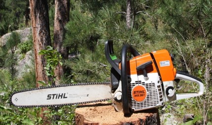
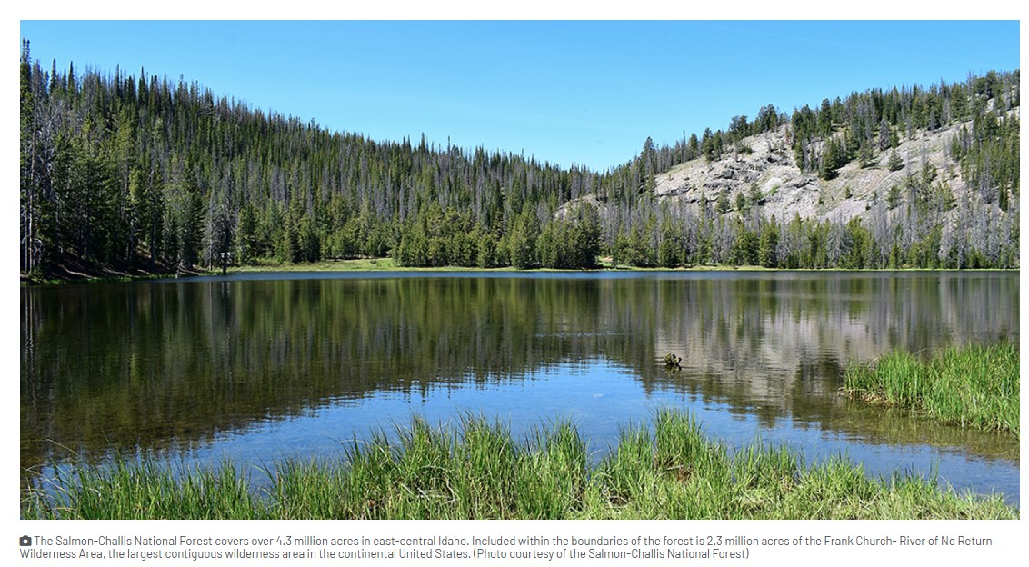
The U.S. Forest Service has granted a rare exemption allowing the use of chainsaws in one of the country’s largest wilderness areas.
The agency on Wednesday approved a request from the Idaho Outfitters and Guides Association to temporarily use gas-powered chainsaws to clear about 542 miles of trails in the Frank Church-River of No Return Wilderness, citing “extraordinary levels” of downed trees. The Frank Church, in central Idaho, is the largest contiguous wilderness area in the lower 48 states.
“This action is necessary to restore safe public access while minimizing impacts to wilderness character and remaining fully compliant with the Wilderness Act of 1964,” Amy Baumer, a spokesperson for the Salmon-Challis National Forest, wrote in an email.
Trees blocking trails
Trail crews typically rely on hand tools such as crosscut saws in designated wilderness areas, which are among the most protected public lands. The Wilderness Act prohibits motorized vehicles and equipment to protect places “untrammeled by man” and to preserve “solitude.”
These exclusions have long been interpreted to include chainsaws, though the Forest Service grants occasional exceptions, usually after wildfires or major storms.
But the Idaho Outfitters and Guides Association (IOGA) petitioned the agency last year, arguing that decades of wildfire and disease have created an unmanageable buildup of fallen trees. A Forest Service survey last year estimated between 80,000 and 110,000 trees lying along one 150-mile stretch in the Frank Church.
“Almost half the trails in this wilderness area on the Salmon-Challis are unusable,” said Erik Weiseth, the executive director of IOGA. “Over time, they will just be overgrown and disappear. That is not only hurting our outfitter members, but it’s also hurting the general public. It’s hurting their ability to access the wilderness.”
Weiseth said the blockages have meant lost business for outfitters who can’t get to the spots where they’re authorized to run hunting or guided horseback trips. Volunteers and a shrinking Forest Service workforce have struggled to keep trails open with hand tools, he said. He also pointed to language in the law specific to the Frank Church wilderness, which directs the agency to clear trails annually “to the maximum extent practicable.”
What’s allowed in wilderness?
In a letter on Wednesday, the nonprofit Wilderness Watch asked the Forest Service to delay implementation until 2027 to allow time for judicial review “before the wilderness is overrun with chainsaws.”
George Nickas, the executive director of the Missoula-based organization, called the authorization “just blatantly illegal” and said the organization is considering legal action.
“Getting in there with chainsaws to clear all these trails – it’s all about domination. It’s all about our controlling what’s going on there, our wanting to change the character of the wilderness to meet our demands,” he said. “That’s just the antithesis of what the Wilderness Act is all about.”
The group said it learned of discussions between IOGA and Forest Service officials, including Chief Tom Schultz who is from Idaho, through public records requests. It criticized the agency for not allowing public comment before the approval.
Nickas said the decision could have implications beyond Idaho. Public records reviewed by the group indicated outfitters in Wyoming asked the agency to allow battery-operated chainsaws for trail maintenance.
In 2019, the Forest Service approved chainsaw use in two wilderness areas in Colorado. Conservation groups including Wilderness Watch sued, and the agency later withdrew the proposal.

U.S. Forest Service
The authorization by the Forest Service in the Frank Church allows licensed outfitters to use chainsaws for three years from Jan. 1 through Aug. 1 each year.
Weiseth said that by Wednesday afternoon, authorized outfitters were already in the forest clearing logs.
“This is a big deal to these guys. They’ve been wanting to get some of these trails open for a decade or more,” he said. “They threw their stuff in the truck and started driving to the woods, ready to go.”
This story was produced by the Mountain West News Bureau, a collaboration between Wyoming Public Media, Nevada Public Radio, Boise State Public Radio in Idaho, KUNR in Nevada, KUNC in Northern Colorado, KANW in New Mexico, Colorado Public Radio, KJZZ in Arizona and NPR, with additional support from affiliate newsrooms across the region. Funding for the Mountain West News Bureau is provided in part by the Corporation for Public Broadcasting and Eric and Wendy Schmidt.
News Release: Coalition of Conservation Groups Asks Court to Halt Construction of Stibnite Gold Mine
For Immediate Release: Tuesday, May 12, 2026
Contacts:
John Robison, Idaho Conservation League, (208) 345-6933 x 213
Nick Kunath, Idaho Rivers United, (208) 908-9232
Fred Coriell, Save the South Fork Salmon, (208) 315-3630
Jared Naimark, Earthworks, (650) 213-8052
Marc Fink, Senior Attorney, Center for Biological Diversity, (218) 464-0539
Coalition of Conservation Groups Asks Court to Halt Construction of Stibnite Gold Mine
Boise, ID — A coalition of local and national conservation groups filed a motion preliminary injunction last Friday to halt Perpetua Resource’s pending construction of the Stibnite Gold Project: an open-pit cyanide leach gold mine in the headwaters of the South Fork of the Salmon River. The motion asks to halt construction of the mine on public lands, including constructing a new access road cutting through Idaho’s Salmon River Mountains, in order to protect the environment and “threatened” species.
In February 2025, the conservation groups filed suit in federal district court against the U. S. Forest Service for violating the National Environmental Protection Act and other bedrock environmental laws in approving the mine, which would be located mostly on National Forest lands. The lawsuit is also against the U.S. Fish and Wildlife Service for violating the Endangered Species Act by failing to protect threatened bull trout, wolverine, and whitebark pine. The Forest Service’s own analysis shows that the project area would not be restored as Perpetua claims but would actually be worse off if the project proceeds—even if the proposed restoration work goes perfectly according to plan.
Last fall, the conservation groups and Perpetua reached an agreement allowing limited pre-construction activities to occur while the lawsuit was being briefed. Briefing concluded earlier this year (see “Case Filings” here). Perpetua now seeks to commence “full construction” at the end of May, without waiting for a final decision from the Court.
Among other initial mine construction activities, Perpetua has indicated it will start constructing the Burntlog Route: a second and new access road to the mine site, through protected roadless and riparian areas and threatened species habitat. Perpetua would reconstruct and widen 23 miles of existing road on National Forest to be approximately four times wider than standard roads in the area to accommodate industrial mine traffic. To complete the Route, Perpetua would also build 15 miles of new road through remote wildlife habitat, mostly in inventoried roadless areas.
“The South Fork Salmon River and everything and everyone who depends on it are at risk if the government allows our public lands to be monetized to benefit billionaires,” said John Robison, Public Lands and Wildlife Director for the Idaho Conservation League. “We believe the South Fork Salmon River deserves its day in court before Perpetua Resources and its financiers rush ahead and make irreversible changes to this special area.”
The Stibnite site is 45 air miles from McCall, Idaho, adjacent to the Frank Church–River of No Return Wilderness Area and is within the homelands of the Nez Perce Tribe. Perpetua’s massive mine plan entails excavating three open pits. It would create 280 million tons of waste rock and include constructing a 475-foot tall, 120-million-ton tailings storage facility—more than 1.5 times taller than the Statue of Liberty. One of the open pits would extend more than 720 feet beneath the riverbed of the East Fork South Fork Salmon River. Perpetua would also build an extensive web of roads, power lines, and other industrial infrastructure across public lands to reach the remote mine site.
“We’re seeking to prevent this special part of Idaho from being irreversibly damaged before the legal process has run its course,” said Bryan Hurlbutt, staff attorney at Advocates for the West and counsel for the conservation groups. “Our preliminary injunction motion asks the Court to preserve the status quo until it issues a final ruling in the lawsuit.”
“Rushing to construct the mine is just one more instance of Perpetua putting its profits first, instead of being the ‘good neighbor’ the company pitches to the community,” said Judy Anderson of Save the South Fork Salmon.
“In light of Perpetua’s push to begin full construction, court intervention is necessary to protect critical habitat in the South Fork Salmon watershed from damages that simply cannot be undone,” said Nick Kunath, Conservation Director at Idaho Rivers United. “This watershed and all that it provides deserves much more than allowing Perpetua to plow forward with damaging activities before the case before the court has had a chance to be resolved.”
“The rush to make a profit is not more important than the law,” said Jared Naimark, Western Mining Senior Manager at Earthworks. “Legal protections exist to ensure the South Fork of the Salmon River, our National Forests, and the animals that call these lands and waters home are taken care of for generations to come. The proposed Burntlog route is an unlawfully approved second access road. It would damage protected roadless areas and streams and harm endangered wolverine and bull trout. Perpetua Resources must not construct the road before the courts have decided whether the project is allowable. That damage can’t be undone once it happens.”
###
Save the South Fork Salmon strives to protect and preserve the ecological, cultural, and economic resources of the South Fork of the Salmon River watershed and the well-being of the people that depend on them for generations to come.
www.savethesouthforksalmon.com
Idaho Conservation League’s mission is to create a conservation community and pragmatic, enduring solutions that protect and restore the air you breathe, the water you drink, and the land and wildlife you love.
Advocates for the West is a non-profit, public interest environmental law firm headquartered in Boise, Idaho, that works to defend public lands, water, fish and wildlife throughout the American West.
Idaho Rivers United’s mission is to protect and restore the rivers and fisheries of Idaho, and is the only conservation organization in the state focused exclusively on the health and protection of river resources.
Earthworks mission is to protect communities and the environment against the adverse impacts of mineral and energy development while seeking sustainable solutions.
The Center for Biological Diversity is a national, nonprofit conservation organization with more than 1.7 million members and online activists dedicated to the protection of endangered species and wild places.
American Rivers is championing a national effort to protect and restore all rivers, from remote mountain streams to urban waterways.
By now, you’ve likely seen local, regional, western, and national coverage of the Trump administration’s plan to reorganize the Forest Service.
The proposal includes moving the agency’s headquarters from Washington, D.C. to Salt Lake City, eliminating the 9 Regional Offices, establishing 15 new State Offices (including one in Boise), setting up a network of Service Centers, and consolidating 77 Research Centers into as few as 20.
Hundreds of conservation groups and outdoor companies are sounding the alarm, warning that the Forest Service is essentially being dismantled. In response, the Forest Service itself took the unusual step of releasing a “Myth vs. Facts” statement in an attempt to push back on that narrative.
Several retired Forest Service supervisors describe the proposal not as a dismantling but as a “flattening” of what they see as a top and middle management-heavy (muffin-topped) organizational structure. In their view, the changes could ultimately be beneficial—reducing costs, improving efficiency, and helping staff get more work done. The Forest Service Chief also noted that no changes would be made until after this year’s wildfire season.
Still, the massive pushback against the reorganization (“Blink twice if you are being kidnapped, Smokey”) reflects a far deeper concern: many people who value public lands see this as part of a broader pattern—one that could ultimately lead to weakening protections and selling off public lands.
liminating Regional offices and creating State offices
Currently, North Idaho forests are managed out of the Region 1 office in Missoula, Montana, while south Idaho forests are managed out of the Region 4 office in Ogden, Utah. Replacing regional offices with state offices could make sense—if done thoughtfully. The Bureau of Land Management (BLM) already uses a state-based structure with reasonable success, but that model depends on adequate staffing and resources.
However, as currently envisioned, the Forest Service State Offices would be staffed by only a handful of employees and would lack the full complement of Regional staff who have special expertise in mine engineering, forest pathogens, cultural resources, and Treaty Rights, and more. While the newly proposed Service Centers could house some of these experts, that is not stated in the current plan. The result could be further loss of institutional knowledge when we can least afford it.
The importance of a Washington presence
While maintaining local District Ranger and Forest Supervisor offices makes sense for working with local communities, the Forest Service leadership also needs to engage directly with members of Congress and other federal agencies in critical matters like budgeting and coordination. Key decisions are made in D.C, not Salt Lake City. A reduced presence there could leave the Forest Service at a distinct disadvantage. As the saying goes, “If you’re not at the table, you’re on the menu.” A diminished Washington office might lead to reduced funding, staffing, and ability to keep the Forest Service intact.
Institutional knowledge
One of the biggest risks is the loss of staff with critical institutional knowledge. When the last Trump administration moved the BLM’s headquarters from Washington, D.C. to Grand Junction, Colorado, hundreds of employees retired or left their jobs rather than relocating. These people never came back. The move didn’t result in savings but instead a significant loss of expertise.
We have the same concerns here. To make matters worse, the Forest Service is already dealing with staffing gaps following last year’s senseless, chaotic and illegal DOGE-related cuts. While some staff were hired back, many were not. This reorganization could exacerbate those losses. Furthermore, Congress is not being consulted about this reorganization.
Research at risk
Forest Service research stations collect critical data on watersheds, fisheries, wildlife, forest health, and silviculture, among many other topics. Consolidating or closing these stations raises serious concerns (“It’s just madness”)—especially if long-term study sites and datasets are abandoned in the process. These Stations are essential in generating applied research which is essential for preparing for disasters and guiding restoration. Weakening them now is a step in the wrong direction.
The Ugly
While ICL has questions about the real intent behind the reorganization, the more troubling issues arise over changes in priorities, policy, and by extension, land management—particularly around public review of proposed projects.
The Forest Service argues that this reorganization will move decision-makers closer to the public so the agency can better serve them. However, at the same time, recent changes to NEPA regulations reduce or remove opportunities for the public to learn about and provide input on Forest Service activities. So while decision makers may be geographically closer to you, they are now no longer allowed to host public comment periods for the majority of the projects affecting Idahoans.
This reality is already playing out. Take the Upper Bigwood Vegetation Management Project near Galena in the Sawtooth National Recreation Area for example. This 2,500-acre proposed project—in a landscape that is highly visible, well used, and well loved—would typically be analyzed through an Environmental Assessment (EA) with scoping and comment periods. These public comments provide community members with meaningful opportunities to shape the project,helping to optimize treatment activities and minimize negative impacts. In the past, the Forest Service has made substantive project improvements as a result of public comments. However, under the new regulations and the new Emergency Authorization, this project is proceeding without an official public comment period (there is an open house on May 11). That represents a significant shift away from public participation.
The Forest Service isn’t dead…at least not yet. The Ranger Districts, Forests and Forest Supervisor offices are all still here. The agency even hired seasonal staff for trail work. And citizen-led forest restoration collaboratives like the Boise Forest Coalition continue to connect communities to the Forest Service. But the reform the agency truly needs isn’t the proposed “structural overhaul”—or preparation for disintegration—but a restoration of the funding and adequate staffing to fulfill its mission: “Caring for the Land and Serving the People.”
The recently announced major restructure of the U.S. Forest Service may disrupt a number of forestry positions in Idaho. But the details as to how those positions will be affected and what work will continue or be eliminated under the plan remain unclear.
Anna Webb, an entomologist and federal employee union representative based in Boise, received a notice about two weeks ago that her position in the agency would be affected. The letter said affected employees may have to move, find another position within the federal agency, or resign.
There was no expected timeline to the changes.
“It makes things difficult to plan,” Webb said, speaking to the Idaho Capital Sun in her capacity as a union representative. “It causes unprecedented amounts of stress.”
Leaders of the federal employee union that represents Forest Service employees for the Boise, Payette, Salmon-Challis and Sawtooth national forests are concerned about the disruption to local employees as well as the potential long-term consequences to forest health. READ MORE: 2026-04-22 USFS Restructure

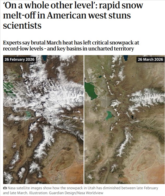 Snow surveys taking place across the American west this week are offering a grim prognosis, after a historically warm winter and searing March temperatures left the critical snowpack at record-low levels across the region.
Experts warned that even as the heat begins to subside, the stunning pace of melt-off over the past month has left key basins in uncharted territory for the dry seasons ahead. Though there’s still potential for more snow in the forecast, experts said it will probably be too little too late.
“This year is on a whole other level,” said Dr Russ Schumacher, a Colorado State University climatologist, speaking about the intense heat that began rapidly melting the already sparse snowpack in March. “Seeing this year so far below any of the other years we have data for is very concerning.”
Acting as a water savings account of sorts, snowpacks are essential to water supply. Measurements taken across the west during the week of 1 April are viewed as important indicators of the peak amounts of water that might melt into reservoirs, rivers and streams and across thirsty landscapes through the summer. READ MORE
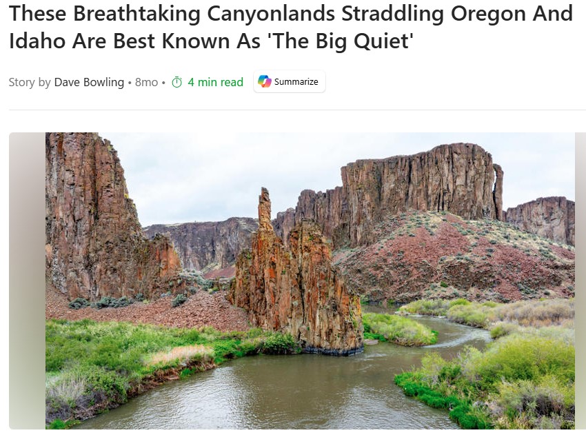
For many travelers, a summer adventure means photographing or traversing some of Mother Nature’s incredible works of art. Unfortunately, many of the iconic National Parks are so crowded that they require reservations in advance. If you’re looking for challenging hikes, excellent fishing, breathtaking canyon views, and epic whitewater without the crowds, consider the spectacular Owyhee Canyonlands, locally known as “The Big Quiet.” This largely untouched area covers nearly 9 million acres of Eastern Oregon, Southwestern Idaho, and Northern Nevada, beckoning visitors with an incredibly diverse range of geologic features, desert life, and adventurous experiences.
As the Owyhee Canyonlands stretch for hundreds of miles, there are several points of entry. The closest major metropolitan area with an airport is Boise. If you’re flying in, you’ll need to rent a 4×4 with high ground clearance and drive nearly 90 minutes to get to the edge of the wilderness area. Double-check that your rental car agreement permits off-road driving, or consider a specialty company such as Ribik. READ MORE
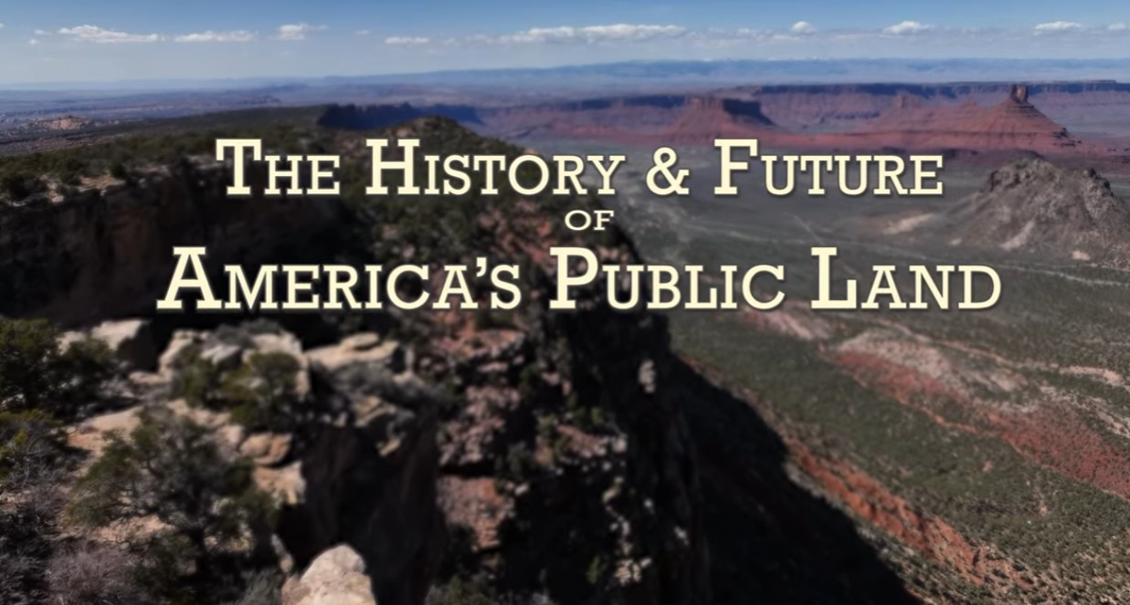
Walt Dabney, former National Park Service Superintendent and Texas State Park Director, discusses the history and future of America’s public lands. This presentation was filmed at a guide and outfitters training in Moab, Utah. CNHA has supported the parks and public lands of southeastern Utah since 1967. Sales from our retail outlets & online store, memberships and donations support the education and research efforts of our public land partners: The National Park Service, Bureau of Land Management and USDA Forest Service.
 The Camp Fire that started it all
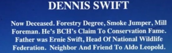
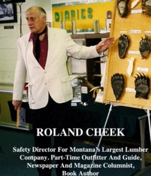
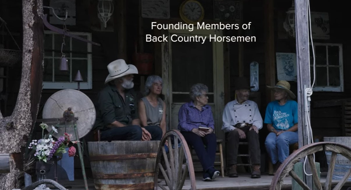
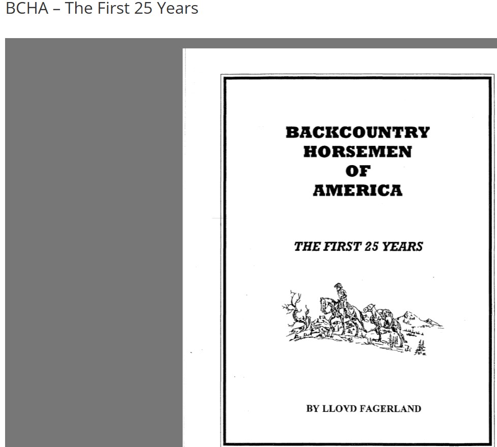
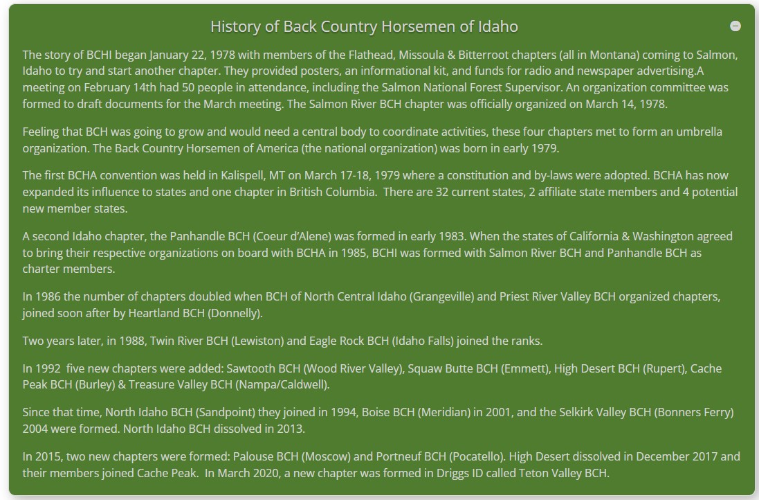
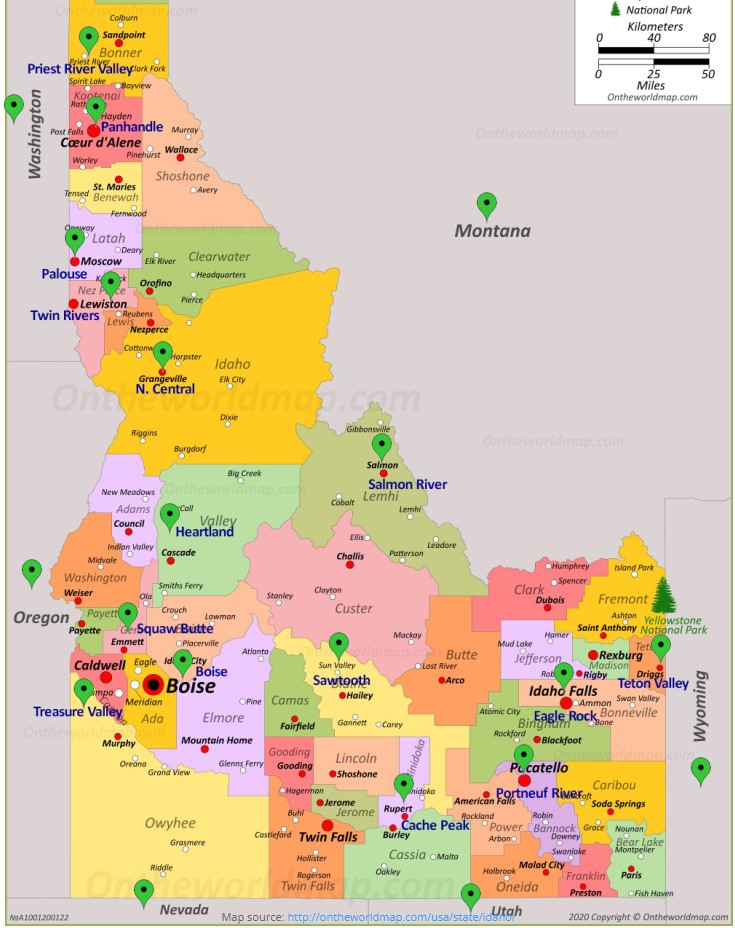
BCHA Founders

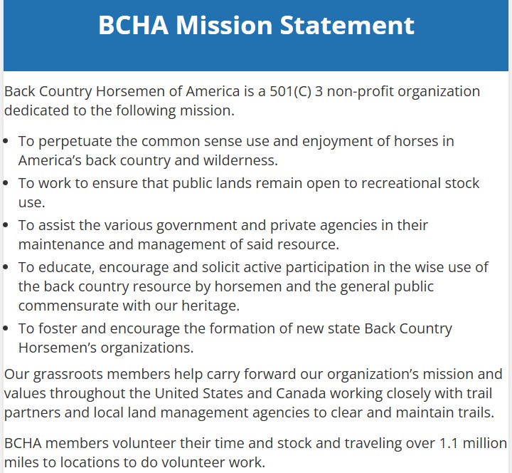
BCHA, Who we Are and How to Help

There is a lot of confusion about the chainsaw protection standards and how they vary around the world.
Type C, Class 1, chainsaw fabric layers, chainspeed, test methods ….
Understanding the global chainsaw protection standards is becoming increasingly important as arborists explore work opportunities in different countries and as arborist retailers start shipping outside their home country.
We thought that it was time to put a comprehensive guide to chainsaw protection standards together. Grab your popcorn and read on.
The Two Main Global Chainsaw Protection Standards
Broadly speaking, all of the current global standards for chainsaw protective legwear can be classified under two headings: European and North American.
- European: currently this is ISO 11393, published in 2018, which replaced EN381
- North American: The USA standard,ASTM F1897, is the main document for North America so will be referred to in this paper.
The standards under either of these headings specify the general requirements for design and construction, the protective coverage areas, the performance testing needed, the certification process and the labelling and marking information required.
The Australian/New Zealand standard, AS/NZS 4453 and the Japanese standard JIS T 8125: 2022 are virtually direct copies of ISO 11393, so for the purposes of this paper these will be grouped under the European heading.
The Canadian standard, ASTM F3325, is very similar to ASTM F1897 so comes under the North American heading READ MORE
 Your chainsaw safety gear is important. Really important. Continuing cases of chainsaw injuries show that there is a real need to educate chainsaw operators on the correct selection and use of chainsaw safety gear.
This guide examines the different styles and options of chainsaw PPE available to the user and how to choose the best chainsaw protection for your unique situation.
There are two main types of chainsaw safety apparel, chainsaw trousers or chainsaw chaps. Both have the special fabric permanently sewn into the garment. Within each of these styles of garment there are variations designed to meet the differing needs encountered by those who use a chainsaw.
When deciding which style and which product is best suited for your needs there are a number of factors to consider:
1. How often you use the chainsaw
2. The type of work you are doing
3. The environment you are working in
4. The quality/durability you desire
5. The standards and/or regulations governing the work you are doing
6. You/your company’s budget and safety culture
Factor 1: How often you use the chainsaw
If you are using a chainsaw frequently as part of your normal daily work, you should consider wearing chainsaw pants rather than chaps. In general, pants will be lighter overall than chaps worn over a pair of standard jeans. Chainsaw trousers will be more comfortable and there are no straps that can get snagged on branches or machinery.
Think about the time taken to put chaps on and off during a day, whereas with trousers you always have your chainsaw protection with you.
From a company’s perspective, if the staff are all wearing chainsaw trousers, you will have peace of mind knowing that good safety practices are being followed. With chaps, it is all too easy to avoid the hassle of putting them on just to perform a small cutting job.
Modern chainsaw trousers are made using technical fabrics and complex designs for a better fit and higher level of comfort. READ MORE
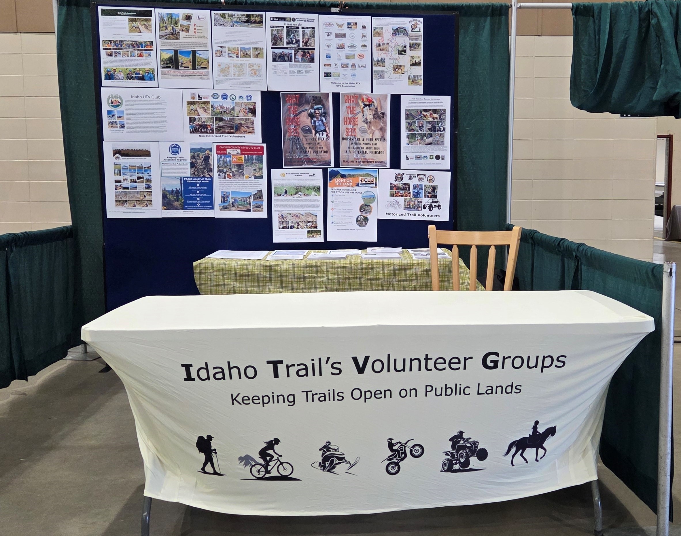
Back Country Horsemen of Idaho hosted a booth at the Idaho Sportsman Show March 5-6 that informed the public about all the various volunteer groups that do trail work on public lands as part of their charter. Members from BCHI, ITA, SBFC, TVTMA, Boise Ridge Riders, CC-ATV, Emmett Rough Riders and Idaho ATV manned the booth during the show and handed out information about both motorized and non-motorized group that might be of interest to the show attendee’s. They also told the public what their specific group does on public lands and how to get involved. The general feeling was the booth was very successful and these groups have committed to supporting a “Trails” booth in 2027/
Trump’s Pick to Lead National Parks? An Executive Who Manages Private Hotels Within National Parks
The White House announced a new director of the National Park Service (NPS) last week — and parks advocacy groups are not happy about the choice.
Hospitality executive Scott Socha is President Trump’s pick to lead the NPS, according to a list of new federal appointments announced on Feb. 11. Unlike many past directors of the NPS, Socha has no apparent experience in public service or conservation.
Moreover, Socha’s company, Delaware North, specializes in hotels and resorts, many of which are located within national parks. Delaware North has even successfully sued the NPS over the ownership of iconic names, including “Yosemite National Park.”
The Senate must still confirm the nomination of Socha, who is “totally qualified” to implement Trump’s plans for the parks, a White House spokesperson told GearJunkie on Tuesday. “Scott looks forward to implementing America First initiatives, such as increasing park access for American families, reducing permitting burdens, and raising money for conservation projects,” spokesperson Taylor Rogers said.
However, parks groups point out that Trump’s plans for the park service have also included a proposed $900 million cut, which parks organizations have said would shutter hundreds of NPS sites around the country.
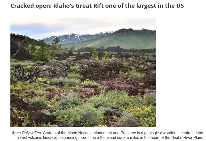
And within it lies something just as remarkable: the Great Rift — a chain of deep volcanic cracks and fissures stretching across the landscape.
According to the Bureau of Land Management, it’s considered one of the largest and most recently formed volcanic rift systems on land in the continental United States.
“At 635 square miles, it is considered to be the largest, deepest, and most recent volcanic rift system in the continental United States,” the agency notes. “Many of Idaho’s most fascinating geological features lie along this potential wilderness.”
Idaho’s Great Rift is one of only a few known volcanic rift systems of its kind on Earth. Another, far more expansive rift, stretches from Ethiopia to Mozambique in eastern Africa.
“The Great Rift System is a volcanic rift zone that consists of eruptive fissures, cinder cones and other volcanic vents, non-eruptive fissures, and faults confined to a narrow belt,” the National Park Service’s website notes. “Most of the recent volcanic activity on the Snake River Plain is located along volcanic rift zones, which trend roughly perpendicular to the axis of the Snake River Plain.”
The Great Rift begins at Craters of the Moon — the northernmost lava field. The rift cuts down over 50 miles southeast from the Pioneer Mountains, landing at the Wapi Lava Field.
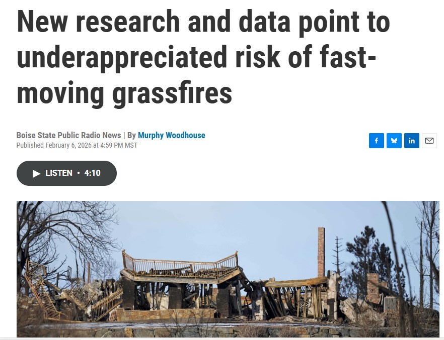
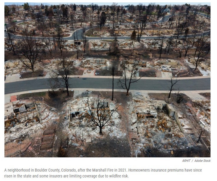
 Something wicked nearly returned to the Colorado Front Range as 2025 drew to a close. Records were being set throughout December, with temperatures reaching well into the 70s.
And then the winds came.
“We have wind potential that could gust up to 100mph for some folks today,” CBS News Colorado’s Alex Lehnert told her viewers on Dec. 19.
For the first time in Colorado history, the National Weather Service declared a “Particularly Dangerous Situation” for Boulder County and other nearby communities. Standard red flag wildfire warnings were issued for a long swath that stretched north into Wyoming.
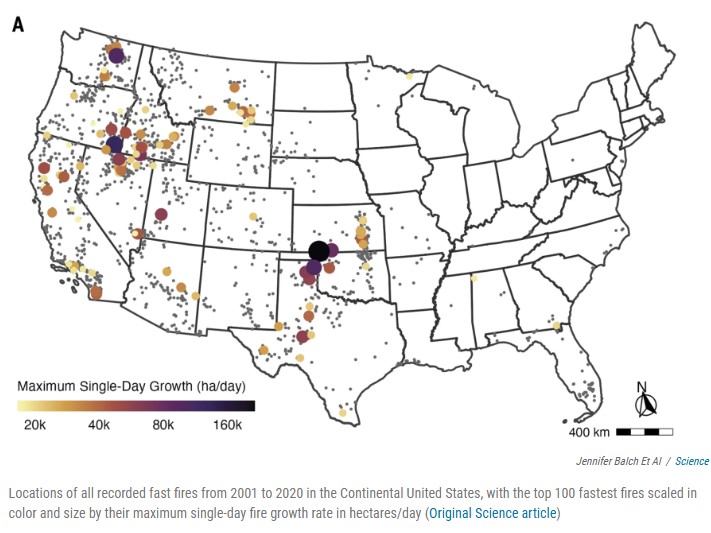
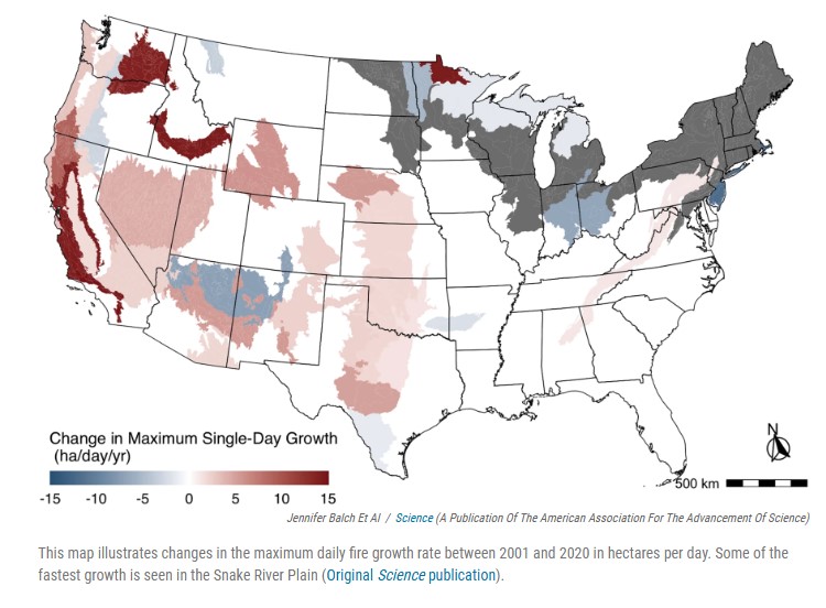
The extreme weather posed “a significant threat to life and property in the event of a wildfire start,” the Boulder County Sheriff’s Department warned residents. “New or existing fire ignitions will have a high risk for very rapid fire spread.” READ FULL STORY: MWNB – Fast Moving Grassfires
 Josephine Woolington Feb 2026
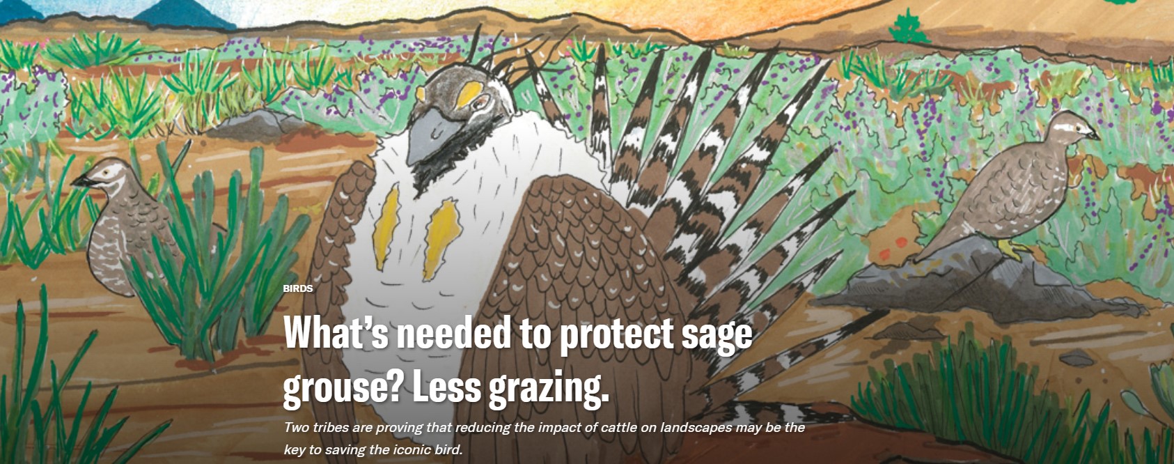
As a child, Lytle Denny learned where blue grouse, ruffed grouse, sharp-tailed grouse and greater sage grouse lived. A member of the Shoshone-Bannock Tribes, he scouted the high-desert landscape during family hunting trips on the tribes’ ancestral homelands in southeastern Idaho. His dad preferred hunting deer and elk, but Denny developed an affinity for grouse.
The family hunted together as a group. Denny moved quietly through the silver-green sagebrush, hoping to hear the sudden heavy wingbeats of a startled bird. His family watched, waiting for a flush, not just of grouse but of mammals, too. “So it worked together,” he said. “We’d get birds and big game.” READ MORE
Rare bird: Sage grouse are both unique and imperiled
Much of sage grouse physiology and behavior — from the yellow air sacs that males inflate during mating displays to the species’ preference for eating plants — is unusual for a bird.
Avian evolution has favored light weight for easier flight, leading to hollow bones and small organs. But sage grouse evolved “heavy machinery,” as Boise State University researcher Jennifer Forbey described it — large organs and specialized guts — to digest sagebrush leaves, which are toxic to most animals.
From September to February, sage grouse eat sagebrush almost exclusively, preferring the tiny, silver-green leaves of low-growing species like early and mountain big sage. Scientists have found that these species fluoresce under ultraviolet light due to chemical properties in their leaves. Sage grouse have photoreceptors in their eyes that allow them to see UV light, and researchers like Forbey think that this glow may help the birds locate the plants. Female grouse teach their chicks where to find food, passing on what Forbey called “nutritional wisdom.” Both males and females return to the same breeding, nesting and chick-rearing sites every year, generation after generation.
But the birds’ loyalty and diet are no longer well-suited for today’s landscape, transformed since settlers arrived.
Every year, 1.3 million acres of sagebrush steppe is lost, primarily to wildfires fueled by cheatgrass that has spread, in part, by way of extensive livestock grazing. Unfortunately, animals that rely heavily on one food source — like koalas, pandas and sage grouse — “tend to be the most vulnerable to extinction,” Forbey said. — Josephine Woolington
 Bookmark our 2026 Idaho Wildlife Bill Tracker to keep the bills that matter in your scope.
Find your local legislators https://legislature.idaho.gov/legislators/whosmylegislator/
Public Lands – US House votes Wednesday to strip conservation measures that safeguard the wilderness
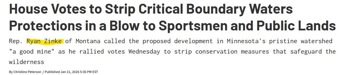
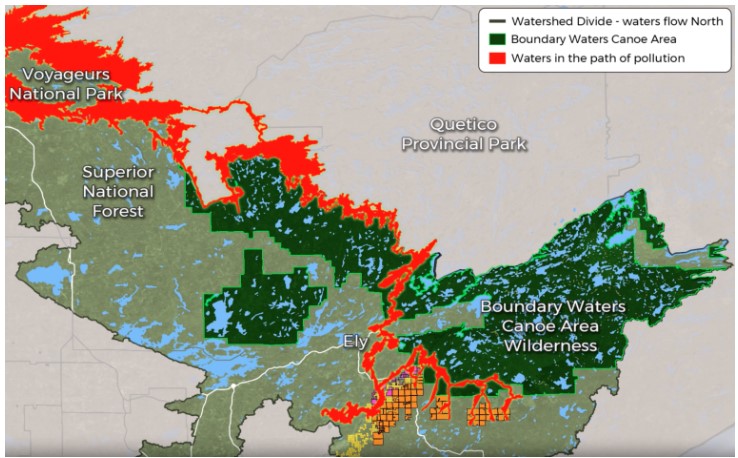 The U.S. House of Representatives narrowly passed a resolution Wednesday that puts a copper-nickel mine on the edge of the Boundary Waters Canoe Area Wilderness one step closer to reality. Taking an unprecedented approach to using the relatively novel Congressional Review Act, the House voted 214-208 in favor of overturning a 20-year mining moratorium that was established in 2023. These current protections cover 225,504 acres in the Superior National Forest and center around the Rainy River Watershed that lies upstream of the BWCA.
“The Boundary Waters is the pinnacle of wild places,” says Matthew Schultz with Sportsmen for the Boundary Waters. “The chance of polluting a place like that to me is pretty crazy. It just doesn’t shake out.” READ MORE
We’re looking forward to hosting a number of webinars over the next few months to help get you ready for hiking season.
Come learn about our Youth Trail Program for ages 14-18!
February 10 @ 6pm PT/ 7pm MT
Learn how to make backcountry meals that are simple, nourishing, and actually taste good with Kristina Schmid, founder of EmpowHer Outdoors.
February 11 @ 6pm PT/ 7pm MT
This is your chance to get a sneak peek at the year’s best projects and learn how you can be part of making a difference on Idaho’s incredible trails.
February 26 @ 6pm PT/ 7pm MT
Basic Wilderness Survival & First Aid Webinar
Kristina from EmpowHer Outdoors will help you build confidence in the outdoors by learning essential wilderness survival and basic first aid skills.
March 11 @ 6pm PT/ 7pm MT

 WHAT’S BEHIND ALL THIS deferred maintenance? According to Forest Service staffing
reports from 2019, the agency’s workforce has contracted substantially over the last 30
years, losing roughly 20% of its staff. Under the Trump administration, full-time staffing
has decreased by an additional 10% due to DOGE layoffs, though this
month’s Congressional appropriations bill spared the agency the worst of the drastic
2026 budget cuts proposed by the White House last year.
Recreational trail staff, once robust in the 1980s, has dwindled with these reductions in
force, with many districts reporting zero, or just one, permanent recreation staff and
fewer than three seasonal staff to oversee hundreds of miles of trail. A July 2025
internal Forest Service report, shared with me by a confidential source, concluded that
each of the agency’s nine regions were missing up to 80% of their trail and recreation
workers.
December’s follow-up Forest Service report quoted a chorus of disaffected anonymous
rangers. “My trail program is suffering the worst morale setbacks of all my district
programs,” said one acting district ranger. “We lost 200 years of trail experience this
year,” said a forest recreation manager. One district trail manager was considering
packing in a multi-decade career altogether. “It feels like 24 years of trails and
wilderness work,” they said, “rolling back to the bottom of the hill.”
Volunteers and local stewardship groups have had to show up in force, demonstrating
the value Americans place on access to public lands. In fiscal year 2023, 71,660
volunteers contributed 2.6 million hours of service to the Forest Service, more than
double the hours logged by agency employees. Yet even that tidal wave of donated labor
can only slow, not reverse, the decline of infrastructure compounded over decades of
mismanagement.
At the highest levels of government, on both sides of the aisle, politicians acknowledge
this systemic neglect. During his Senate confirmation hearing, now-Secretary of the
Interior Doug Burgum agreed that addressing the maintenance backlog was crucial: “We
just have to make sure not just the national parks, but across the whole department, we
have to get the formulas right, because we are creating liabilities for future generations
if we are not taking care of that deferred maintenance.”
READ FULL STORY: Public Land Trails are Disappearing
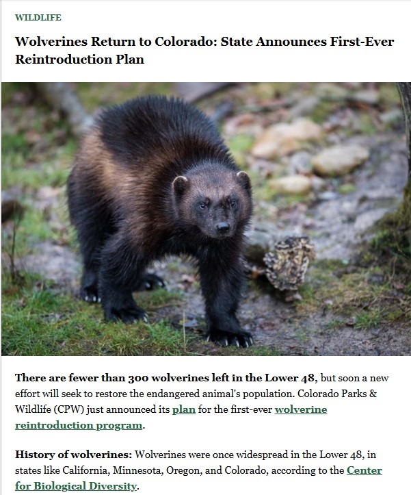 There are fewer than 300 wolverines left in the Lower 48, but soon a new effort will seek to restore the endangered animal’s population. Colorado Parks & Wildlife (CPW) just announced its plan for the first-ever wolverine reintroduction program.
History of wolverines: Wolverines were once widespread in the Lower 48, in states like California, Minnesota, Oregon, and Colorado, according to the Center for Biological Diversity.
Since the early 1900s, the population has sharply declined, mostly due to trapping and habitat loss. In 2023, they were added to the Endangered Species List.
Why reintroduce? Beyond helping revive an endangered species, reintroducing the wolverine has other benefits. The animal is naturally an opportunistic scavenger-predator. In addition to hunting small mammals like squirrels and rabbits, they’ll eat leftovers from carcasses of sheep, caribou, and moose that other, larger predators have left behind.
As the nonprofit Defenders of Wildlife explains, “Wolverines play an important role as nature’s cleanup crew. By scavenging dead animals, they help recycle nutrients back into the ecosystem and reduce disease spread by eating carcasses.”
What’s the plan? According to CPW, over 94% of the planned reintroduction habitat is on federal land. The areas include parts of Rocky Mountain National Park, the Elk and West Elk Mountains, and the San Juan Range.
The department will release 15 wolverines per year for 3 years beginning in 2027. Depending on how the species fares, there may be more reintroductions. Since wolverines have very large home ranges, the state can support around 100.

Good morning and Happy New Year! As we reflect on the accomplishments of 2025, I want to extend my heartfelt gratitude to each of you for your dedication to our Squaw Butte Chapter. Your contributions were vital in achieving our goals, as evidenced by the impressive totals we logged this year: 1,405 personnel hours, 467 trail miles, 8,892 travel miles, and 82 stock with 92 stock days, culminating in a total value of $73,408.66. Thank you for your commitment and hard work; it truly made a difference.
2026 will bring many more adventures and a lot of opportunities to get involved!
I have included a copy of the report that has been sent to BCHI and the BCHI proposal to move the hours and miles report due date to September 1st.
Please remember that there will not be a meeting tonight. See you all in February!
Lisa Baer
Squaw Butte Back Country Horsemen End of Year Summary 2025
Back Country Horsemen of Idaho Proposal Hours Coordination 2026

BOISEDEV ICYMI 2025
In Case You Missed It: Some of our best stories of the year
A company owned by Texas billionaires Dan and Faris Wilks is selling 73 ranch sites carved from about 2,000 acres south of Cascade.
Plans for Legacy Creek Ranch, as dubbed by DF Development, look like subdivisions across Valley County, but are not subject to the same rules and review process because the ranch sites were created by a series of lot line adjustments and original parcel splits.
That, Valley County Planning and Zoning Administrator Cynda Herrick said, is the difference between selling raw land and being required to follow the county’s subdivision laws.
“I’ve been talking with (DF) and they understand that this isn’t the preferred method,” Herrick told Valley Lookout. “But it’s what they’re entitled to by law.”
The method used by DF enables Legacy Creek Ranch to avoid the county’s subdivision requirements, which include plans for drainage, irrigation, drinking water, septic systems, utilities, and streets.
It also means that the company is not required to create a fire protection plan covering things like water supply, emergency access, and vegetation management.
The plan also avoids review by the Valley County Planning and Zoning Commission, as well as several state agencies, including the Idaho Transportation Department, the Idaho Department of Environmental Quality, and the Idaho Department of Water Resources. READ MORE
Volunteers clear nearly 500 fallen trees from Forest Service roads | Coeur d’Alene Press https://share.google/6dS7zogwVPNW5DTuF
 Volunteers assess road conditions in the Fernan Hill area following last week’s high winds. Volunteers removed nearly 500 fallen trees from area Forest Service Roads over the weekend.
It’s not just snowmobilers that recreate on North Idaho’s National Forest land, said Back Country ATV and UTV Association President Bret Uhlich.
Hikers, cross-country skiers and even sled dog teams take advantage of the groomed backroads and trails that make winter recreation accessible.
“We all love the backcountry,” Uhlich said.
It was this love for the backcountry that united 75 volunteers Saturday, enough manpower to clear nearly 500 fallen trees along Bunco Road, Fernan and the Fourth of July Pass.
Most volunteers were members of local organizations, including the Back Country ATV and UTV Association, the Coeur d’Alene Snowmobile Club and multiple Jeep clubs.
“Calls for action” were issued last week after high winds tore through North Idaho, downing trees, damaging infrastructure and resulting in one death.
One member of the Snowmobile Club had driven up into the Fernan Saddle area Wednesday to assess the road conditions and found trees nearly 2 feet in diameter toppled across the dirt road.
The club member was able to clear a quarter mile of the roadway by himself.
“Progress is possible, but it is slow, hard work,” the Snowmobile Club shared to social media Dec. 18.
With volunteers split into nine teams, several dozen miles of roadway were cleared of downed trees and other debris.
Cutting and moving the downed trees out of the roadways will save groomers both time and resources once the area receives significant snowfall, said Coeur d’Alene Snowmobile Club President Steven Cox.
The work will also allow outdoor enthusiasts to access the trails earlier in the season.
“I figured we should use the brief window we have before it started to snow,” Cox said.
These efforts underscored the importance of organizations like the Snowmobile Club, he added.
“This shows exactly what the need for this club is,” Cox said. “It was really good to see how many people came together to do this.”
And though there’s still plenty more work left to do, time and weather will determine whether crews can safely get back out there.
“There’s more to go, but unfortunately it’s a little dicey out there,” Uhlich said.
Much of Wyoming outside of Yellowstone and Grand Teton also struggles with emergency response time.
By Katie Klingsporn, WyoFile
Wyoming’s U.S. Sen. John Barrasso is pushing legislation to upgrade emergency communications in national parks — a step he says would improve responses in far-flung areas of parks like Yellowstone and Grand Teton national parks.
“This bill improves the speed and accuracy of emergency responders in locating and assisting callers in need of emergency assistance,” Barrasso told members of the National Parks Subcommittee last week during a hearing on the bill. “These moments make a difference between visitors being able to receive quick care and continue their trip or facing more serious medical complications.”
The legislation directs the U.S. Department of the Interior to develop a plan to upgrade National Park Service 911 call centers with next-generation 911 technology.
Among other things, these upgrades would enable them to receive text messages, images and videos in addition to phone calls, enhancing their ability to respond to emergencies or rescues in the parks.

Each year, rangers and emergency services respond to a wide range of calls — from lost hikers to car accidents and grizzly maulings — in the Wyoming parks’ combined 2.5 million acres.
Outside park boundaries, the state’s emergency service providers also face steep challenges, namely achieving financial viability. Many patients, meantime, encounter a lack of uniformity and longer 911 response times in the state’s so-called frontier areas.
Improving the availability of ground ambulance services to respond to 911 calls is a major priority in Wyoming’s recent application for federal Rural Health Transformation Project funds.

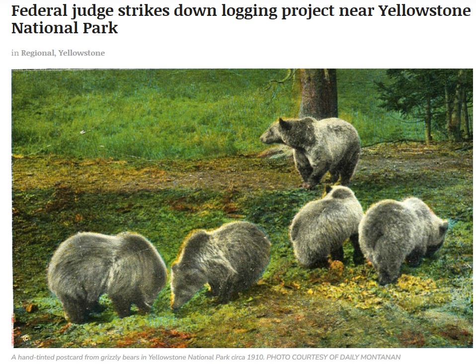
Court said Forest Service plans too vague and failed to consider grizzly bear habitat
By Darrell Ehrlick DAILY MONTANAN
A federal judge halted a large logging project near Yellowstone National Park because he said the United States Forest Service submitted plans that made it impossible to judge how it would affect critical grizzly bear habitat.
The 16,500-acre project located in the Custer Gallatin National Forest would have allowed the U.S. Forest Service to select timber and build roads for logging, but without offering specifics, only pledging that its plans would consider the total distance of the roads and not exceed certain parameters in acreage size, designed to protect critical bear habitat.
However, Judge Donald W. Molloy said that the plans amounted to giving the Forest Service permission and trusting that it would be compliant later. He also said in a 46-page ruling released Thursday that the plans also made it difficult to judge how the logging project would impact grizzly habitat, and that U.S. Fish and Wildlife Service said a female grizzly’s minimum range was 10 acres, while not basing that decision on any cited science. READ FULL STORY
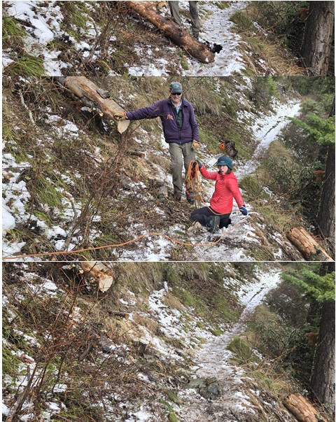

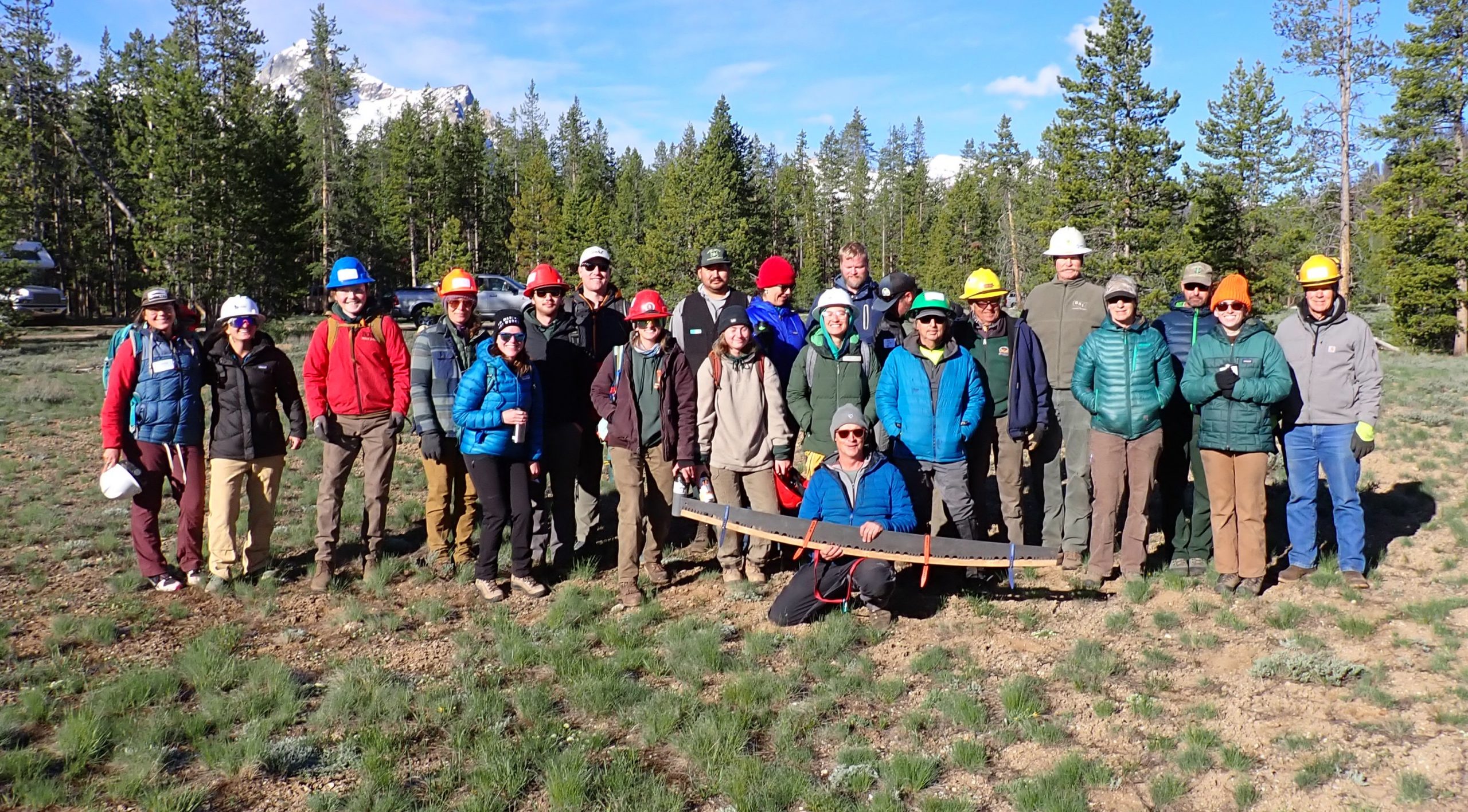
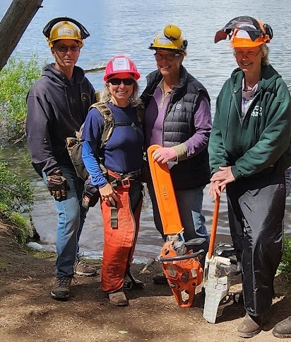
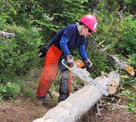
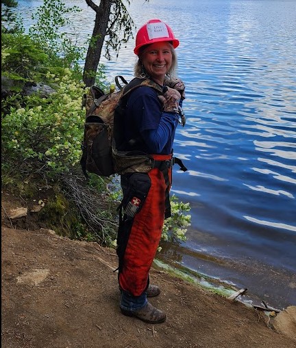
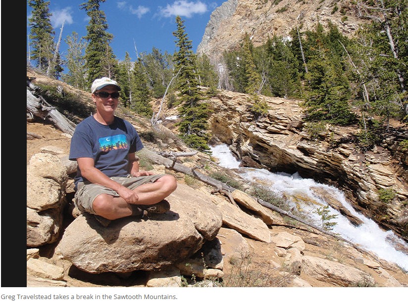 Greg Travelstead spends five to six days at a time working for free with trail crews in the Sawtooth Mountains, Boulder-White Clouds and Frank Church-River of No Return Wilderness.
More recently, he has taken crews to work in Hawaii.
Back in Hailey, he runs Evergreen Advisors, a land-use and water-rights planning company that he started after moving to the Wood River Valley in 2006. He co-founded the nonprofit Pulaski Users Group in 2019 and serves as its board president. Since its inception, the organization has restored 75 miles of wilderness trails, engaging with about 600 volunteers willing to spend time off the grid, using old-fashioned crosscut saws in rugged terrain.
“I have a great deal of respect for those who work full time for land management agencies. They are vastly underpaid,” said Travelstead. “If the Forest Service would have paid more, enough to afford a mortgage, I would have worked for them. But I needed a foot in the business world in order to have significant leisure time to wander in the woods.”
Travelstead, 62, was born in Baltimore and spent his teenage years in Rapid City, South Dakota. He remembers the nearby American Indian Movement occupation of Wounded Knee on the Pine Ridge Reservation and a flood that hit his hometown that killed 300 people.
“Those were interesting times,” said Travelstead, who moved to Boise for his final two years of high school. “The only thing that dug me out from a life of crime and delinquency was my first backpacking trip in the White Clouds Wilderness with my girlfriend. It plugged me into nature and soothed me like nothing else.”
Travelstead earned a geology degree from Rensselaer Polytechnic Institute, thinking it would land him in the woods like a prospector, but remote sensing technology had changed the discipline, so he worked for three years for a self-storage company before going to the University of Colorado for an MBA.
After four years with Arthur Andersen accounting firm, he wound up working as managing director of a diversified holding company in Australia. There he was introduced to the indigenous Bardi people of the Kimberley Region of Western Australia. “I was adopted by the community and learned their customs and traditions,” he said. “One of the reason they were fond of me is that I helped them navigate the Office of Indigenous Affairs and helped them get grants for solar power and for Land Rovers, so they could get around.”
Travelstead has worked in the Wood River Valley on conservation easements, water rights transfers and valuations. His clients have included the Wood River Land Trust, The Nature Conservancy and private landowners.
But his passion is to spend time outdoors. Crews of six to 12 workers take to the wilderness seven times each year. For the last two summers, his Pulaski Users Group crews have been working on an 11-mile stretch of overgrown and damaged trail up Johnson Creek near Grandjean. “The trail was getting so bad that it crisscrossed Johnson Creek and was imperiling critical bull trout spawning areas,” he said. “It’s been incredibly tough just to access the trailhead. We were unable to wrap it up this summer due to the Wapiti Fire.” The Johnson Creek trail work has been funded with a $48,000 grant from the agency coalition known as American Trails. The Pulaski Users Group annual $100,000 budget is covered by donations and additional grants from the National Forest Foundation and Central Idaho Advisory Council.
The organization also works under a five-year cost-sharing agreement with the Forest Service.
“We have only two paid seasonal employees,” Travelstead said. “We are as close to a purely volunteer organization as you can get.”
The Pulaski Users Group works with retirees and students from the Sun Valley Community School and the Flourish Foundation. For three years the crews have been working in Hawaii, on the Big Island and Kauai.
Travelstead said the work they have been doing on trails has ingratiated them with the indigenous Hawaiians.
“At first they thought we were crazy, but now we’re getting invited to family dinners with the locals,” he said.
For more information, go to pulaskiusers.org.
Nearly two-thirds of Idaho land is public, which means that outdoor recreation is not just a huge economic driver, but, for a majority of Idahoans, it’s a way of life. Our public lands are managed by entities including the U.S. Forest Service (USFS), the Bureau of Land Management, Idaho Department of Lands, Idaho Fish and Game, and Idaho Department of Parks and Recreation. And behind the scenes, there are even more organizations working to keep these large acreages of land accessible to all of us. Here are just a few:
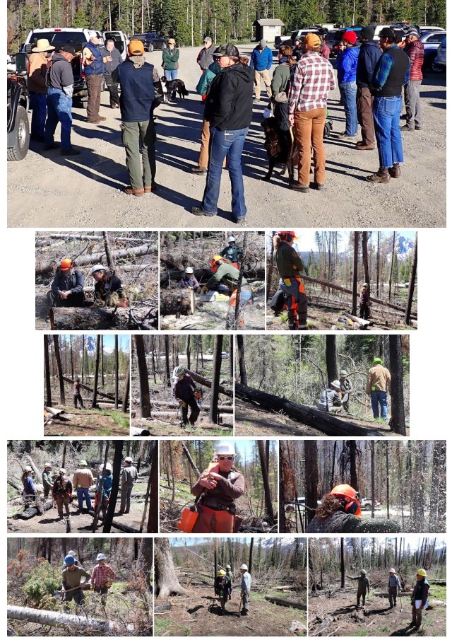
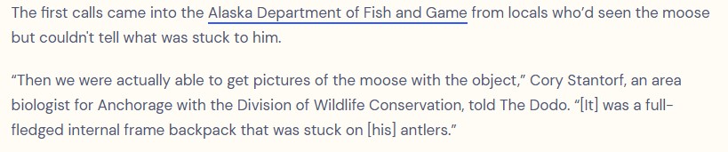
The Idaho Trails Association (ITA) was founded in 2010 and predominantly works on backcountry trails throughout Idaho. However, they’ve also recently expanded into the “front-country” of the Boise foothills and trails adjacent to cities including Pocatello, Sandpoint, and Coeur d’Alene.
In 2025, the ITA had over 800 volunteers with 15,000 hours of volunteer time on over 350 miles of trails. Volunteers don’t need to have prior experience — they receive training before starting projects. Projects range from easy to arduous and range in length from one day to over a week. Traditional tools including crosscut saws, axes, and Pulaskis are used for trail maintenance.
ITA partners with other trail groups to build capacity and work together to get more continuous miles of trail done, Executive Director Melanie Vining said. These include the Back Country Horsemen of Idaho, Great Burn Conservation Alliance, Ridge to Rivers, Friends of Scotchman Peaks Wilderness, and the Selway Bitterroot Frank Church Foundation (SBFC).
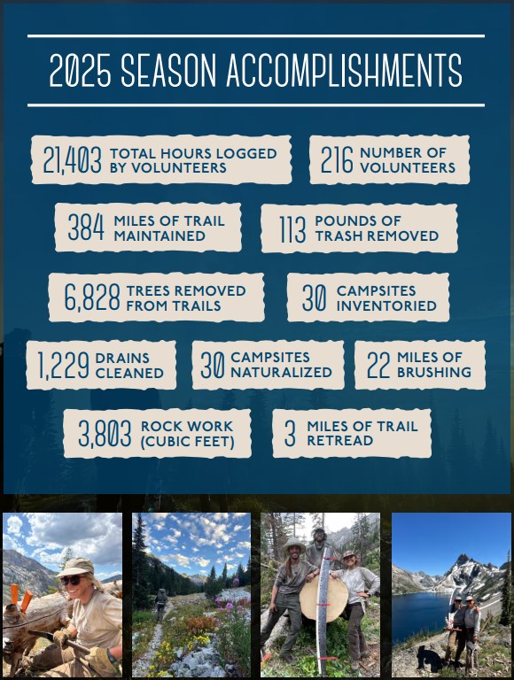
The SBFC was founded in 2006 by concerned citizens with help from the USFS to add capacity for on the ground stewardship in the Selway Bitterroot Wilderness. They added the Frank Church-River of No Return Wilderness to their work around 2012. Both wildernesses are managed by the USFS.
“Having a partner stewardship organization is critical for public lands management agencies, particularly when working in remote/large landscapes like the Selway and the Frank,” said Executive Director Ryan Ghelfi. With recent federal funding cuts, work from these partner organizations has become even more crucial. SBFC has continued to raise private funds to help augment the USFS capacity to get trail work and other stewardship projects done. They were even able to hire River Rangers and Checkers for the Middle Fork and Main Salmon Rivers.
The SBFC has engaged with approximately 200 volunteers this year, both adults and kids, who focused on trail maintenance which included removing downed logs, cutting back brush on trails, and rebuilding tread that had been washed away from time or extreme storms.
The Sawtooth Society was founded in 1997 by a group of landowners, politicians, and recreationalists to assist in preserving the scenic and historical values of the 756,000 acre Sawtooth National Recreation Area (SNRA).
They work with, but independent from, the USFS to assist in maintaining the 900 miles of trails, provide funding for improvement projects, and serve as a liaison for local, regional, and national collaboratives.
In a typical year, they facilitate around 700 hours of volunteer work alongside their paid staff. Volunteers complete a variety of tasks — from stuffing envelopes to bucking trees in the backcountry. With federal funding cuts, the SNRA had its staff dramatically reduced from 34 full-time, non-fire staff to just nine.
The Sawtooth Society was perfectly positioned to help in this situation with its own trail crew infrastructure. They additionally raised $80,000 from supporters to double their trail crew capacity and provide visitor services at the SNRA Headquarters.
“We were able to hire the crew the USFS would have hired, maintaining collective decades of SNRA trail knowledge that would have been lost otherwise. Most importantly, this ensured that trails that are used the most would be open and accessible for the many types of recreation that takes place in the SNRA,” Director of Operations Michael Hoover said.
The Central Idaho Mountain Bike Association (CIMBA) is based in the McCall area. With only two paid employees, the rest of the work is done by volunteers. CIMBA has helped to maintain mountain bike trails at places such as Ponderosa State Park, Brundage Mountain Resort, USFS land, and Jug Mountain Ranch. In the past, they have also partnered with the Central Idaho Trail Riders Alliance on projects. If you like to recreate — whether it’s motorcycles, mountain biking, hiking, or trail running, Trail Coordinator Jared Alexander stressed the importance of getting involved with your local volunteer groups.
Alexander also praised all of the people, or “trail fairies,” that aren’t even out with an organization who help clear trails on their own free time. All of us can be stewards of our public lands.
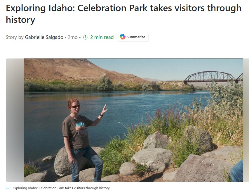
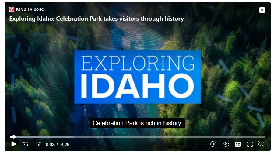
Celebration Park in Canyon County takes visitors on a journey through history, dating back 17,000 years.
Running along the Snake River, the park’s history starts with the geological event that shaped the landscape, the Bonneville Flood.
“A volcanic eruption, they think, diverted more water into Lake Bonneville, causing it to go up higher and hit a soft sediment layer at Preston, Idaho, and then it burst through and went up to the Snake River,” said Nichole Schwend, Canyon County director of culture and natural resources. The prehistoric flood knocked down basalt columns. The pressure from the water rounded the columns into boulders, Schwend said.
The Shoshone, Bannock and the Northern Paiute people later chiseled petroglyphs onto the boulders, Schwend said. The meaning of the petroglyphs is up for interpretation.
“We can’t say for sure what any of them mean,” Schwend said. “You can split those into abstract which nobody agrees on, and then you could talk about them in representational which everyone kind of agrees on.”
The images on the rocks appear to change daily based on the angle of the sun, Schwend said.
For those looking for interactive history, Celebration Park also has atlatl throwing. An atlatl is a Native American spear-like weapon used for hunting. The atlatl predated the bow and arrow.
“These are generally the hunting tool that came before the bow and arrow,” Schwend said. “Sometimes when the bow and arrow arrived in areas it completely replaced the atlatl, other times they overlapped.”
Today, visitors can attempt to shoot a mammoth on hay bales.
On the other side of the park stands the Guffey Railroad Bridge, connecting Canyon and Owyhee counties.
The bridge was built in the late 1890s to transport iron ore from Owyhee County to Canyon County through an electric railroad, Schwend said. When the bridge was completed, it was the tallest railroad bridge in the country.
Unfortunately, the bridge came too late.
“The mines panned out,” Schwend said. “A load of ore never went across.
After the mining rush, the bridge was used to transport livestock. It is said to have carried more livestock than any other rail line in the west.
In the 1940’s Union Pacific pulled all train rails from the bridge, and Owyhee County made plans to scrap the bridge entirely for safety reasons, Schwend said.
“This just became a bridge with huge eye beams across for a long time, and they were worried that, you know, it was inviting somebody to get hurt,” Schwend said.
The bridge was saved by the Idaho Historical Society, which later sold it to Canyon County for a cheap price.
“They bought the bridge from Owyhee County and Tom Bicak, who’s the one who created this, this park here, he knew immediately that he needed that bridge,” Schwen said. “They agreed to sell it to him for $1.”
Today, the bridge is used as a pedestrian bridge, connecting Canyon County to hiking trails on the Guffey and Black buttes.


Rifle Scabbards
I personally hang my rifle scabbard on the off-side of the horse. I attach it with the rifle butt toward the front at about horn height, and angle the rifle barrel slightly toward the back.
Here’s why:
The barrel of the rifle extends under my stirrup leather and I never know it’s there. This keeps the weight on the front quarters of the horse where he can carry it best. On the off chance I should spot game while in the saddle, I can pull my rifle out before I dismount. Hanging the shotgun scabbard or rifle scabbard on the off-side can help offset your weight when mounting.
One additional note, if you use an open ended leather or nylon rifle scabbard and hang it with the butt toward the rear, your rifle could end up missing. I have heard many stories where folks have found their rifle way back on the trail because they never knew it had been snagged on a branch and yanked out of the gun scabbard.

Pack Saws and Camp Axes
When I attach my pack saw and its scabbard or my camp axe in its sheath. I prefer to attach my saw scabbard with the saw handle tied to the front strings and the blade coming just under my leg. I usually pack my camp axe on my pack mule to the outside of a mantied load, but you can certainly attach it to your saddle if you prefer an axe. An axe sheath is designed with rings to tie your saddle strings to. This hangs the axe at an angle where it is easy to secure the handle out of your way.

Bow Scabbards
When hanging a Bow Scabbard, I secure it to the rear of the saddle behind the cantle and angle it slightly forward so that my bow is facing toward the rear with the quiver to the outside. I prefer this attachment method because with the bow scabbard pointed toward the rear, my horse is free to turn tightly to the right without being hindered by the bow. And once again, the weight of the bow and bow scabbard are on the opposite side from me when I mount the horse, helping to offset my weight as I mount.
Pack Saws & Axes
How do I hang a pack saw on my saddle?
One sure way to secure a saw to your riding saddle is to tie the pack saw handle with the rear saddle strings and then secure the blade under your leg. However, the pack saw scabbard has a versatile design that would allow you many options. Whichever way you choose, remember to offset the added weight of your saw by loading your horse saddlebags or horn bags heavier on the opposing side.
Why do I need to carry a pack saw or a camp axe with me on the trail?
The obvious answer here is for windfall blocking the trail. It is not always possible to go around a windfall, nor would you necessarily want to get into that habit; the new trail you would create only adds to the erosion of a potentially fragile area. It is better instead to simply clear the trail. Read the article “Pack Saws and Camp Axes” for a full explanation of why it is so important to carry a pack saw when you are out on the trail.
https://idahocapitalsun.com/2025/09/18/volunteers-sought-for-public-lands-cleanup-in-idahos-sawtooth-national-recreation-area/
Volunteers have collected garbage, broken up illegal fire rings and removed human waste
The House voted to nullify three Bureau of Land Management plans, and critics fear many more could follow.
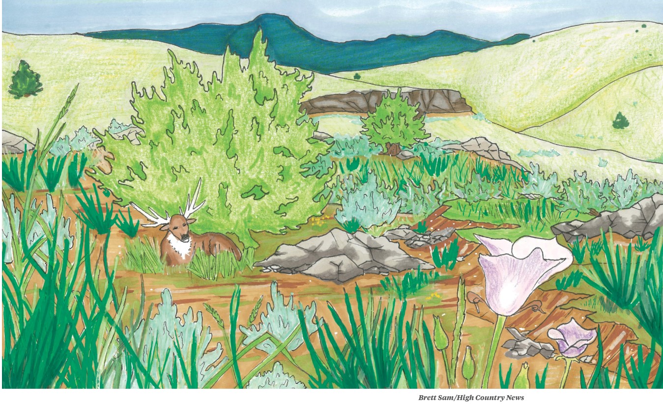
On the sagebrush plains of eastern Montana, cattle graze alongside mule deer, and pumpjacks rise from coal seams. For nearly a decade, the future of this landscape was hammered out in the Miles City Resource Management Plan, a compromise shaped by ranchers, tribes, hunters, energy companies and conservationists. Now, with one vote in Washington, Congress has thrown that bargain into doubt, and with it, decades of public-lands decisions across the West.
Finalized in November 2024 after years of debate and litigation, the Miles City plan is one of the nation’s largest, governing 12 million acres of BLM land and 55 million acres of federal mineral estate across eastern Montana.
But on Sept. 3, the U.S. House of Representatives voted to overturn three Bureau of Land Management plans, including Miles City, under the Congressional Review Act, the first time the law has ever been applied to land-use planning. Legal experts and conservation groups warn that the consequences could be far-reaching, enabling Congress to unravel decades of environmental protections and management decisions on public lands.
Resource management plans serve as guidelines for how the BLM manages the public lands it oversees. The plans are developed through a lengthy process that combines local and tribal input with environmental review under the National Environmental Policy Act. The goal is to create a blueprint for “multiple use” management, balancing economic activities such as grazing and oil and gas development with other concerns, including wildlife habitat, outdoor recreation and conservation.
In Montana, the disappearance of that blueprint will have immediate consequences. Ranchers face uncertainty on how many cattle they can run, when their permits will be renewed, and what will happen during a serious drought. Tribal cultural sites are likely to be left unprotected and years of tribal consultation overridden. Conservation groups warn that congressional vetoes could sideline science-based safeguards for vulnerable habitats. In Miles City, the resource management plan would have reformed coal seam leases near the Powder River Basin; without those reforms, habitat for elk, mule deer, sharp-tailed grouse and pheasants could be fragmented by new energy development.
The Miles City plan drew input from ranchers, tribes, energy companies, hunters, outdoor recreation groups and conservation groups, and its supporters argue that undoing it sets a dangerous precedent.
“It’s disregarding all the conversations that have happened on the ground,” said Land Tawney of American Hunters and Anglers. “That balance sometimes isn’t perfect for anybody, but it’s a path forward for all.”
Jeanine Alderson, a rancher based near Birney, Montana, said that local ranchers are deeply concerned.
“The biggest reality is the uncertainty, because we’re doing this for the long haul,” Alderson said. She fears it will “just create an endless cycle of litigation that could grind grazing permits to a halt.”
Alderson said the resolution prioritizes the concerns of faraway bureaucrats over local ranchers’ input. “Those of us who live with this don’t have any say in what happens to the land we own and have leased for generations,” she said. “It was a collaborative process, and to have that overturned in one fell swoop is stunning.”
The 1996 Congressional Review Act allows Congress to overturn agency rules within a 60-day window using only a simple majority, bypassing the filibuster. This is the first time resource management plans have ever been treated as “rules.”
“That’s why we’re at an inflection point,” said Chris Winter, director of the Getches-Wilkinson Center at the University of Colorado Law School. (Disclosure: Winter serves on High Country News’ board of directors.) Resource management plans, he said, have never been submitted to Congress for review. “Applying it now could unravel decades of land-use planning practice,” he said.
The CRA was employed only once before 2017, but the first Trump administration dramatically expanded its use. If this resolution stands, it would subject all RMPs to possible congressional approval, throwing every element of the planning process into doubt. According to Michael Blumm, a professor at Lewis & Clark Law School, this reinterpretation “calls into question the legitimacy” of the more than 100 plans finalized since the Congressional Review Act became law.
Conservationists and legal experts worry about the act’s “substantially similar” clause, which bars agencies from issuing a new rule that resembles one Congress has rejected. Because the law doesn’t define what counts as “too similar,” an agency could be left in limbo, without guidance on revision, and unable to try again if its replacement is judged to mirror the disapproved version.
“In the absence of guidance, agencies are going to be scratching their heads without a lot of concrete direction,” Winter said. “That will create a lot of confusion and litigation risk.”
Some see this as the latest attempt by the Trump administration to hollow out public-lands protection by stripping authority from land-management agencies and giving it to Congress instead. Montana Reps. Troy Downing and Ryan Zinke, Republicans who have long styled themselves as advocates for small government and local control, both supported the resolution — even after Zinke opposed public-land sell-offs earlier this year. (Neither responded to a request for comment.) Now, the resolution heads to the Senate for a vote within 60 days.
“I fear that this strategy is going to lead to arguments that the system isn’t working, that the agencies aren’t being effective,” said Winter. “And that all of it becomes justification for dismantling the public-lands system over time.”
~~
Zoë Rom is a writer and journalist based in Colorado’s Roaring Fork Valley. Her work has appeared on NPR and in Outside, and she is the author of Becoming a Sustainable Runner, about how outdoor athletes can become environmental stewards.