 Those of you who studied and commented recently on the Canyonlands EAST TMP know the drill and will have had a practice run to now turn your attention westward. And you know from the last pass what is at stake for recreationists in this second of five related sub-region TMPs under BLM’s Boise District, Owyhee and Bruneau Field Offices.
Road and trail mileages proposed to be accommodated under the Action Alternatives (B, C, D) and mapping will vary for this sub-region, in part due to a 2021 land swap which increases the ground in the analysis area and route inventory in the Alternatives. I will more thoroughly analyze the Plan and report further in the future, but the basic approach and what’s at stake should feel familiar with the info provided here.
Sub region area outline in light blue, Alternatives route inventory in dark blue; Table 2.6 from Pg 19 of the EA summarizes mileage and access types proposed to be retained under each Alternative:
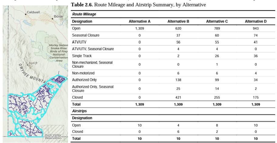
Table 2.6 notes: “Open” and “Seasonal Closure” are effectively full-width routes; ATV/UTV width class is unique and newly defined as <65″ with the release of EAs for Canyonlands East and West TMPs.
This is not a reboot of the NEPA process from the beginning but a continuation of the TMP process paused in 2017. The documents to be analyzed and commented upon are the near-final versions of the Plan for the Canyonlands WEST Sub-region. This is explained in the BLM’s E-Planning FAQ page which I encourage you to read at the link below and which applies to all five related Sub-regions similarly.
Except for inventoried routes added as part of a 2021 land swap, there will be no new analysis for any routes if such were not included in the original 2009 inventory. Commentary will therefore only be considered for the routes in the proposed Alternatives, and we do not anticipate BLM will accept any proposed “new” routes due to the restrictions of the 2009 OPLM Act that “stopped the clock” at that time of the Act’s passage by Congress.
With thanks to a fellow traveler for assembling the basis of the following text, if you’ve seen it already, know that I’ve made a few edits to clarify some details.
This will not be a rolling multi-year Decision release process for the five Sub-regions, but instead as stated BLM anticipates having all five Sub-region Decisions wrapped up on a fairly fast-track, by March 2024.
Alex Ernst
IDPR, Land Access Coordinator
~ ~ ~
Canyonlands WEST TMP EA public stage NEPA process: 45-day comment period open
BLM Press release: https://www.blm.gov/press-release/blm-update-second-travel-management-plan-owyhee-county
E-Planning site (Project homepage, map links, NEPA documents, etc.): https://eplanning.blm.gov/eplanning-ui/project/73196/510
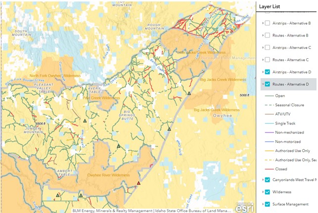
BLM’s Interactive Route Alternatives Map: https://blm-egis.maps.arcgis.com/apps/webappviewer/index.html?id=ac06e3f30d684e1c8c7f77f4eb93c6ff
GIS geodata files are here: https://eplanning.blm.gov/eplanning-ui/project/73196/590
- Use the BLM interactive map to zoom in on areas where you recreate. Click on a route to reveal a popup including route identification number and route type to reference in your comments to BLM.
Under the Layers pulldown, select only one letter Route Alternative at a time (A, B, C, or D) which will aid in highlighting closed designations jump out.
- There is no preferred Alternative. B, C, and D are the “Action Alternatives” from which a final selection will be made.
- Under NEPA, the agency must provide a wide range of alternatives.
Alternative A is no action. It will not be selected. If they wanted to leave it as is, they wouldn’t be doing NEPA.
Alternative B could be called the ‘conservation’ alternative… the least number of motor-accessible routes will be implemented.
Alternative C is what they referred to as the ‘balanced’ choice. Even if it is not your preferred alternative, it is important that you list what trails should be included in it that were not.
Alternative D is the ‘wide-open’ alternative. It is important to explain why you support this alternative. Make sure the routes you would like to see designated for motorized use are included.
Explain why any given route is important to loop opportunities. Make sure they are included in both C and D.
Width classes are now identified in the Alternatives: single-track, <65″ ATV/UTV, and full-width/road. This is a significant change compared to the 2016 drafts which failed to define width class. Comment if you anticipate an inappropriate width class will be applied to any given route.
Background information:
There are five BLM sub-regions under the Boise District involved in this TMPing initiative. Canyonlands WEST is the second sub-region of the five to be released for public comment, and the rest will be released successively over time for public review in the same manner. The FAQ states an anticipated Record of Decision on all five TMPs by March 2024. But realistically, timing will be determined by staffing issues and by the political climate.
The five sub-regions are Canyonlands East, Canyonlands West, Silver City, Grand View, and Birds of Prey.
The primary issues include: Soil, Vegetation, Hydrology, Wildlife, Recreation, Cultural concerns