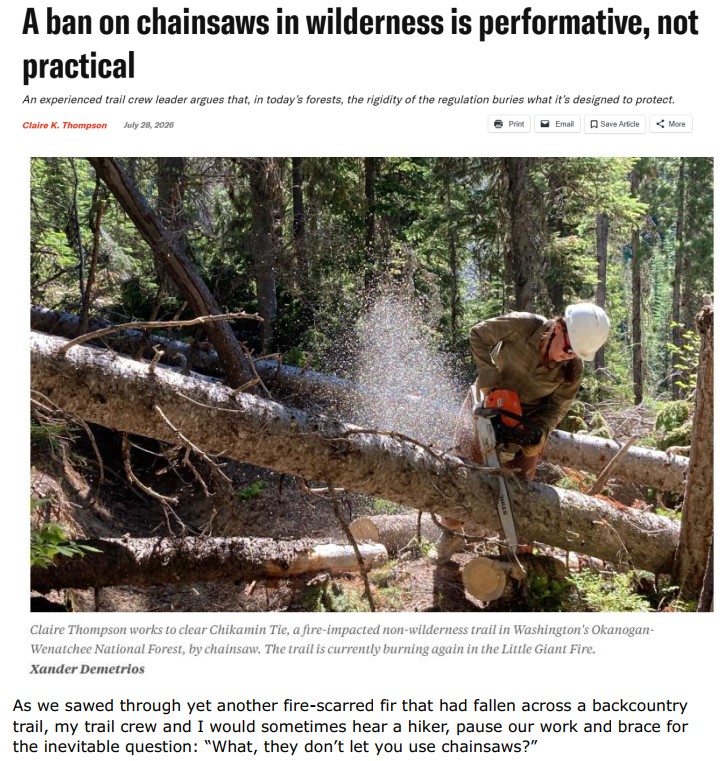
Ban on chainsaws in wilderness

 Sawmill Fire Swamper Chainsaw Cut 2026 | Wildland Fire Lessons Learned Center
 Description:
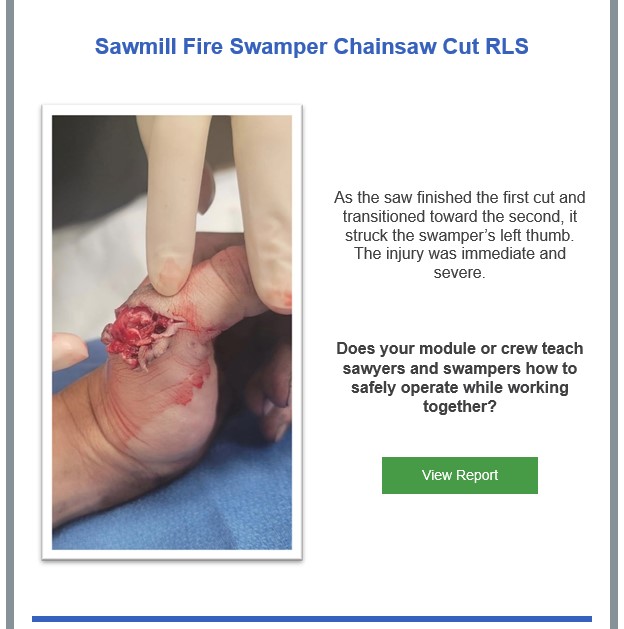
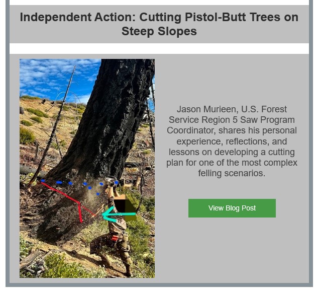
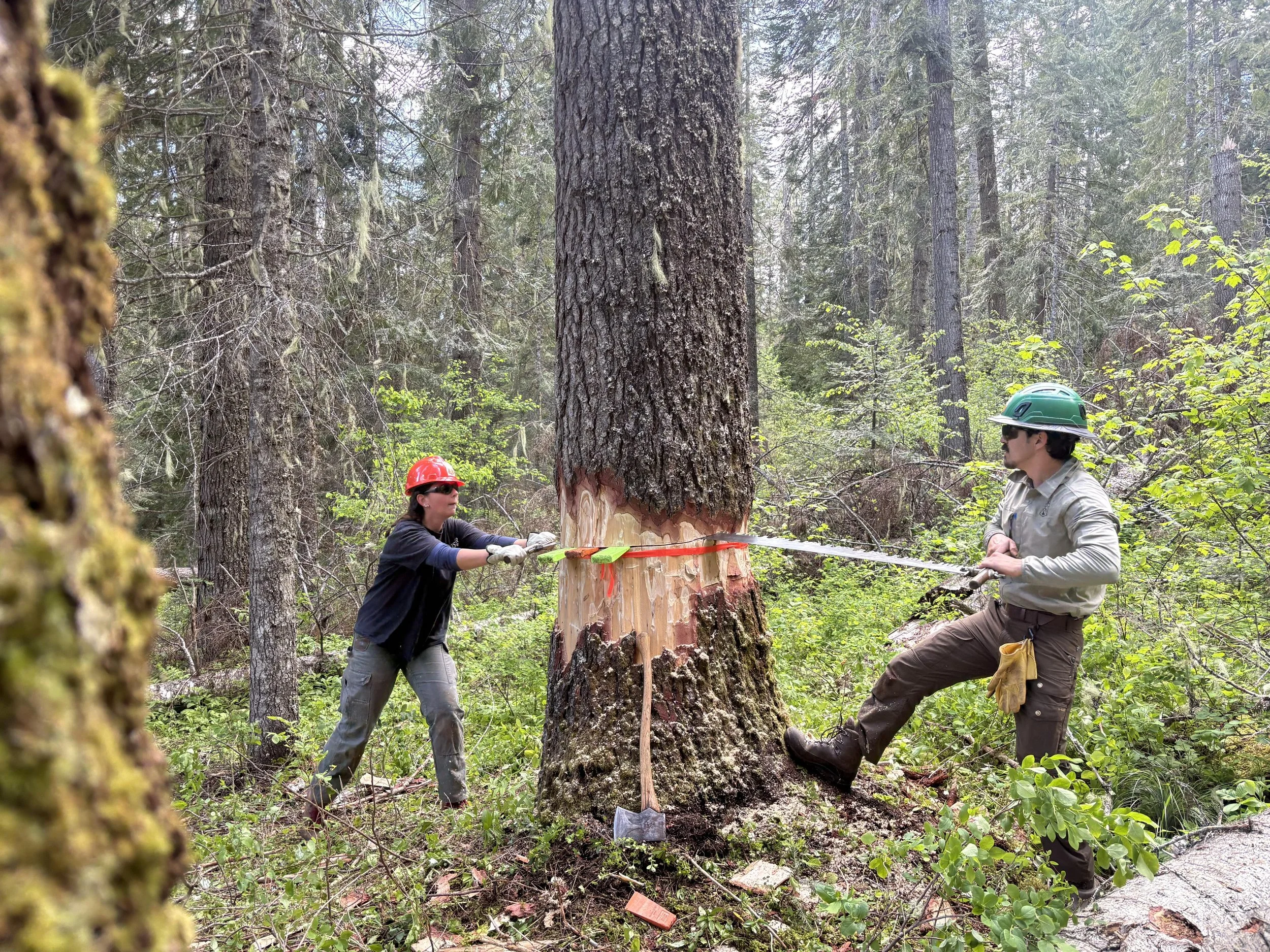
On June 19, 2026, a U.S. Forest Service wildland fire module was assigned to the Sawmill Fire near Cedar City, UT. The module was tasked with securing the fire’s edge and cleaning up ladder fuels to keep the fire out of the canopy. A saw team module, consisting of one sawyer and two swampers, moved steadily from tree to tree, limbing junipers while carefully managing each branch to keep it from dropping into the hot duff and subsequently dragging heat out into the “green” side of the fireline.
During one of these operations, the sawyer was cutting through a juniper limb, planning to continue directly into the next one. The swamper stood opposite, holding both limbs—one in each hand—to control their fall. As the saw finished the first cut and transitioned toward the second, it struck the swamper’s left thumb. The injury was immediate and severe.
The injury required eleven stitches for temporary closure. Future surgery will be required to repair tendons that were also severed. The expected recovery period is from six to eight weeks.
Sawmill Fire Swamper Chainsaw Cut RLS
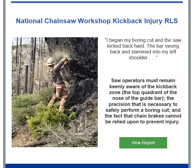

Description: On a clear spring morning in the mountains of northern California, a group of C-Evaluators and U.S. Forest Service Regional Saw Program Managers were gathered for the final day of a national saw workshop.
After sizing up the tree, the faller verbalized the elements of the OHLEC process (a standardized five-step safety and risk assessment framework for tree felling) to the two evaluators. His plan was to take the tree straight downslope (aligned with the primary head lean) into an open lay. He would utilize a double Humboldt face cut using a Stihl 500i chainsaw equipped with a 28-inch bar. The bole of the tree had a distinctly oval shape with the long axis oriented parallel to the slope.
The faller fired up his saw and completed his initial cuts without issue. After knocking out the “pie”-shaped section and cleaning up the face cut, he elected to perform a boring cut straight through the hinge and into the center of the tree. His intent was to remove wood from the middle of the tree to ensure that he had adequate bar length to complete his planned double back cut from the uphill side.
First, the faller verbalizes his intent to “bore the guts” to the evaluators. He then steps downslope in front of the tree, lifts the powerhead and throttles up the saw. As he begins his boring cut, his right hand holds the throttle handle with a palm-down (pronated) grip. His left hand is located near the lower corner of the handlebar with a slightly supinated grip. The kickback occurs almost immediately.
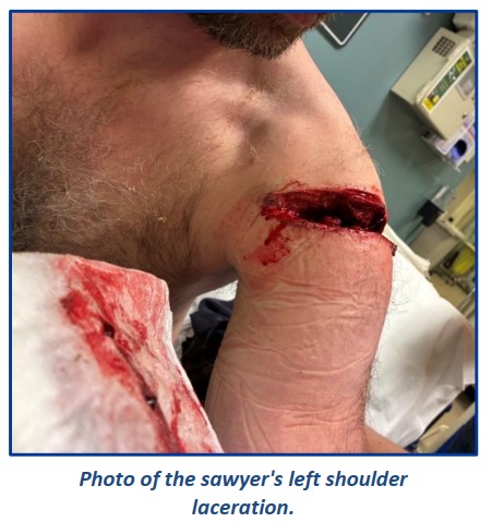
The bar swung back and slammed into the sawyer’s right shoulder.
National Chainsaw Workshop Kickback Injury RLS
Good evening, Please see the following Lessons Learned Center release regarding two saw injuries that happened recently; one due to kick back and one occurring to a swamper. Please review these with your crews and modules to highlight the risks/hazards associated with some chainsaw operations along with some lessons shared by those involved in these events. Thanks and please reach out if you have any questions.
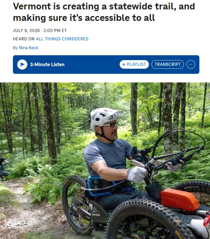
Mountain bike enthusiasts have been working for years on an ambitious 485-mile, multi-use trail called The Velomont that will span the length of the state.
When finished, the collaborative project will knit together existing trail networks, connect 27 communities and include huts and hostels for overnight stays.
New trail construction is finally ramping up after years spent on permits, plans and public input. And organizers say they want to make it as user-friendly as possible.
“For us, it’s not a huge lift to just be mindful when we’re trying to build trail or improve trail to think about the adaptive rider,” said Angus McCusker, the Velomont trail director with the nonprofit Vermont Huts and Trails.
“The challenge,” said McCusker, “is we’re connecting to existing trail networks that were never intended for adaptive bikes. So, where we can, we’re trying to do adaptive assessments.”
Louis Arevalo of Essex Junction is one of several adaptive athletes helping with that, most recently on some slightly overgrown single track trails in Randolph, a central Vermont town nestled along the eastern edge of the Green Mountains.
Arevalo pedals with his hands. He rides an electric powered recumbent-style three-wheeler that sits low to the ground. His service dog Azul chases along nearby.
“Once you realize what these bikes are capable (of) or this equipment actually opens up, it kind of blows your mind,” he said.
Arevalo was paralyzed in a skiing accident six years ago. Being able to get back on the trails has been a game changer, he said smiling.
“There’s a reason we live in the Green Mountain state. It’s because we like to get outside…you know, seeing the squirrels and chipmunks and birds… I mean, it’s life.”
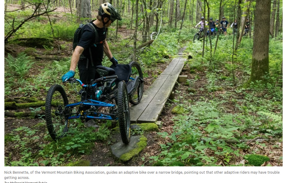
But adaptive rigs like Arevalo’s are wider and heavier than regular mountain bikes, and not all trails are user-friendly.
“It’s helpful to have different kinds of adaptive bikes on these tests because they all handle a little differently,” he said.
Bennette is executive director of the Vermont Mountain Bike Association, another nonprofit spearheading efforts around the Velomont. He and others involved in the assessment are taking detailed photos and notes on ways to make the trails more accessible.
“Just scalloping out a bit of material on the outside of that corner,” said Bennette, pointing to the area the bike got caught. “That will allow adaptive bikes to make that corner without really changing the way the trail rides.”
Jeff Alexander is counting on it. He’s director of strategic partnerships with Vermont Adaptive Ski and Sports, a nonprofit that helps people with disabilities access outdoor recreation.
“So the adaptive community has money, they travel, they want to travel and they want to play with everybody,” Alexander said. “We just need to level the playing field so that everyone can play together.”
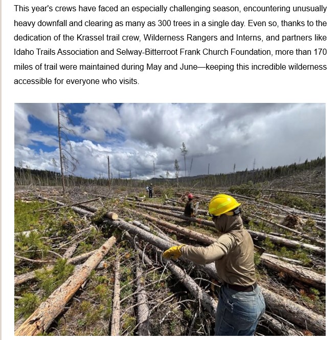
In May of this year, the Salmon-Challis National Forest (SCNF) authorized limited use of gas-powered chainsaws to clear 542 miles of specifically designated trails in the Frank Church-River of No Return Wilderness. Use is limited to the next three years, starting this summer, from January 1 to August 1 of each year, and is limited to users approved by the Forest Service. This work was authorized through a document called the Minimum Requirements Analysis, which you can read about here. Right now, this work is mainly being done by permitted outfitters operating on the Forest.
As a boots-on-the-ground, volunteer-based organization, ITA’s primary focus is on getting trail maintenance done on the ground. When we learned of the chainsaw authorization, our first thought was of our twelve planned projects on the Salmon-Challis National Forest in 2026, and which trails approved for chainsaw use overlapped with our schedule.
This means we need to coordinate closely with outfitters to ensure we know where they are operating saws. Our number one priority is well-organized projects with meaningful, safe, and fun work for volunteers, work that contributes to making trails more accessible for the public. It’s more important than ever to communicate with both SCNF personnel and outfitters as we tackle the projects planned in that area this year. ITA will continue to use non-motorized/non-mechanized tools to accomplish this work in designated wilderness areas.
ITA is focusing on being proactive and communicating up front with the Forest Service and outfitters. Where a trail is planned for clearing by chainsaw, as was the recent case with the Marsh Creek Trail, ITA will assess the site to determine if it is still suitable for a good volunteer project. In the case of our recent Marsh Creek project, the answer was “yes”. The Forest Service trail program lead met our crew on the trail for a weekend of removing large boulders and root wads, brushing and improving tread, all work vital to keeping this trail navigable. We will follow this process for future projects and determine if the work remaining is meaningful and suited to volunteers or if the project is best moved somewhere else.
In the short term, as trail season winds down and after hunting season is over and outfitters are out of the backcountry, we plan to participate in Forest Service and partner meetings to review the first year of this program and identify successes, ask questions, raise concerns and discuss challenges and opportunities to improve coordination between partners and the FS and implementation of the MRA itself with its present requirements and allowances.
Over the longer term- the next three years- ITA will advocate for a long-term solution that recommits to the use of traditional tools as the way to keep trails open in the wilderness.
We will urge Congress to pass adequate funding for both Forest Service staff and partners. The Forest Service needs to restore the right positions in the right places to coordinate and support work by partners like ITA, conservation corps, and outfitters working in their respective areas.
Paid, full-season trail crews are needed. The public land trail system is a national treasure, with tremendous recreational value in today’s times. Recreational value translates to economic value for communities as well. We need trail crews to do all the work – cutting, brushing, tread work, bridges. ITA has proved people value trails; our volunteers worked 16,614 hours on trails in 2025. We are able and willing to learn the wilderness skills to maintain trails. But at the core, we need full-time, skilled Forest Service crews with years of experience to fully utilize volunteers and fully support less experienced paid crews. Over the long term, we need crews on horses and mules or with backpacks, carrying axes and crosscut saws – not chainsaws.
This decision has sparked intense debate. We feel use of mechanized equipment should be the exception to standard wilderness tools and should only be used in emergency situations. Yet, while we look ahead to a future where trails can be maintained using traditional tools, we also must focus on a present where there are hundreds of miles of trails in desperate need of work, from log out to tread repair. We must focus on our role as an on-the-ground organization, dedicated to working with other partners and the Forest Service to get vital work done this season. We care deeply about wilderness and about the traditional tools and skills that have been part of maintaining backcountry trails for decades, and we value our relationships with partners because this will always be a team effort. We will continue to speak for wilderness values while maintaining relationships with our partners, for the good of trails.
Sincerely, Melanie Vining, ITA Executive Director
Federal land agencies want to know how many people are hiking, camping and sightseeing on public lands — and are testing dozens of pilot projects to get better data.
Traditional methods for tracking recreation numbers include trailhead surveys or vehicle counters. But those techniques don’t capture all visitors, especially in less popular areas.
Last year, Congress passed the EXPLORE Act, a package of measures to boost outdoor recreation access as record numbers participate in outdoor activities. It also directed agencies to study new visitation monitoring methods.
Federal agencies including the Interior Department followed up in late June by announcing dozens of pilot projects to evaluate some of the latest techniques. Some are new projects, while others are studies that have already been completed.
Many of the newer methods fall under the category of “digital mobility data,” said Spencer Wood, who directs the Outdoor Recreation and Data Lab at the University of Washington.
Several of Wood’s studies were included in the list of federal pilot projects, such as ones that analyze aggregated call phone data and public social media.
“They post a photograph that says they are having a great time mountain biking – that’s useful information,” he said. “We can observe that by looking at the content of images that people share publicly on social media platforms, or we can understand people’s activities by looking at the way they write a trip report.”
Another option that Wood has studied involves tracking how many people participate in virtual citizen science projects on public lands. Federal agencies say these innovative approaches are promising but need more studying.
Wood said analyzing all the projects could help inform federal land management decisions.
“That might involve questions about what type of infrastructure do they build, where do they improve roads, or where might they improve parking, or where might they work on trail development?”
The federal government is accepting public comments on the pilot projects through July 29.
This story was produced by the Mountain West News Bureau, a collaboration between Wyoming Public Media, Nevada Public Radio, Boise State Public Radio in Idaho, KUNR in Nevada, KUNC in Colorado and KANW in New Mexico, with support from affiliate stations across the region. Funding for the Mountain West News Bureau is provided in part by the Corporation for Public Broadcasting
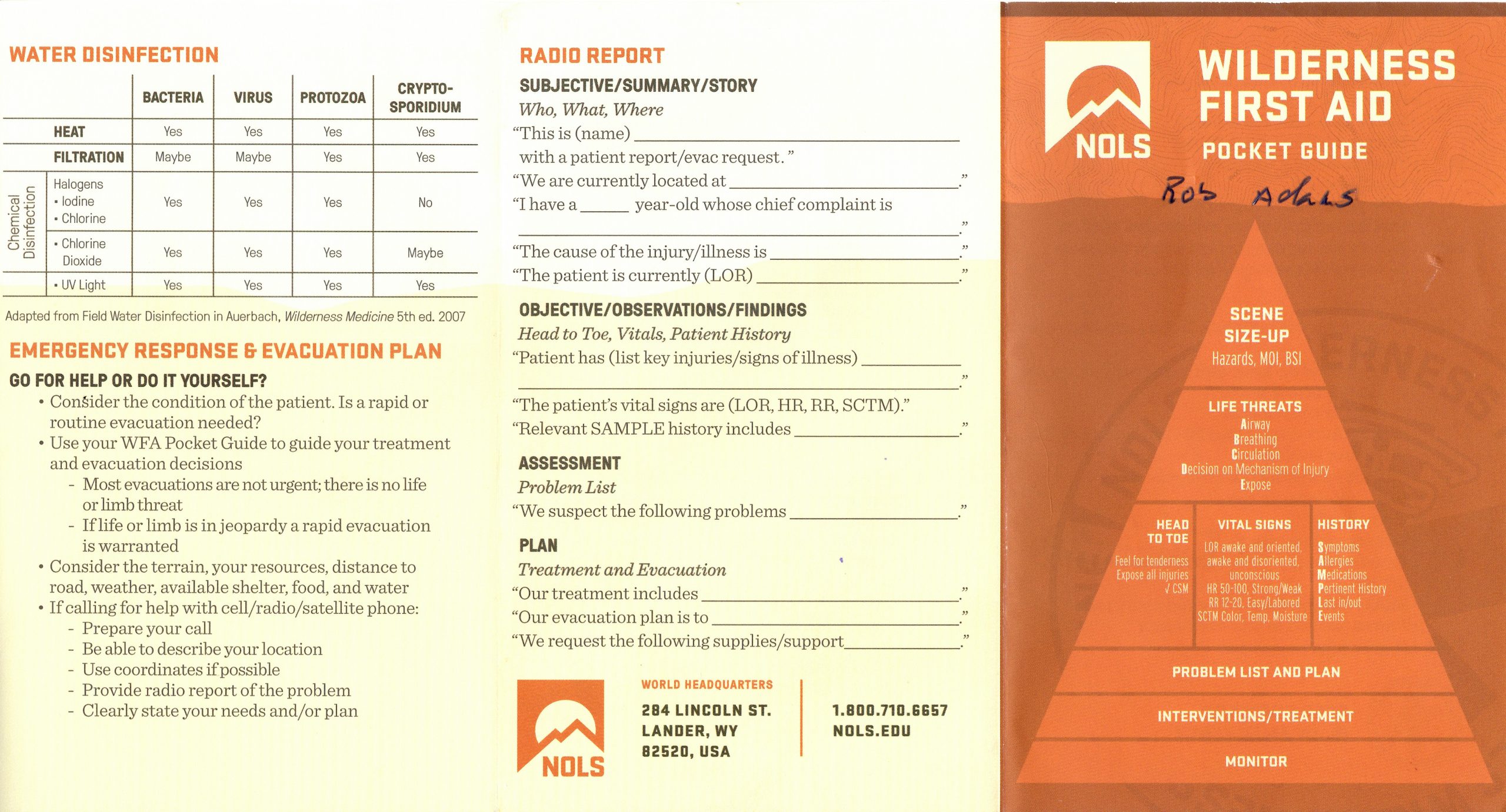
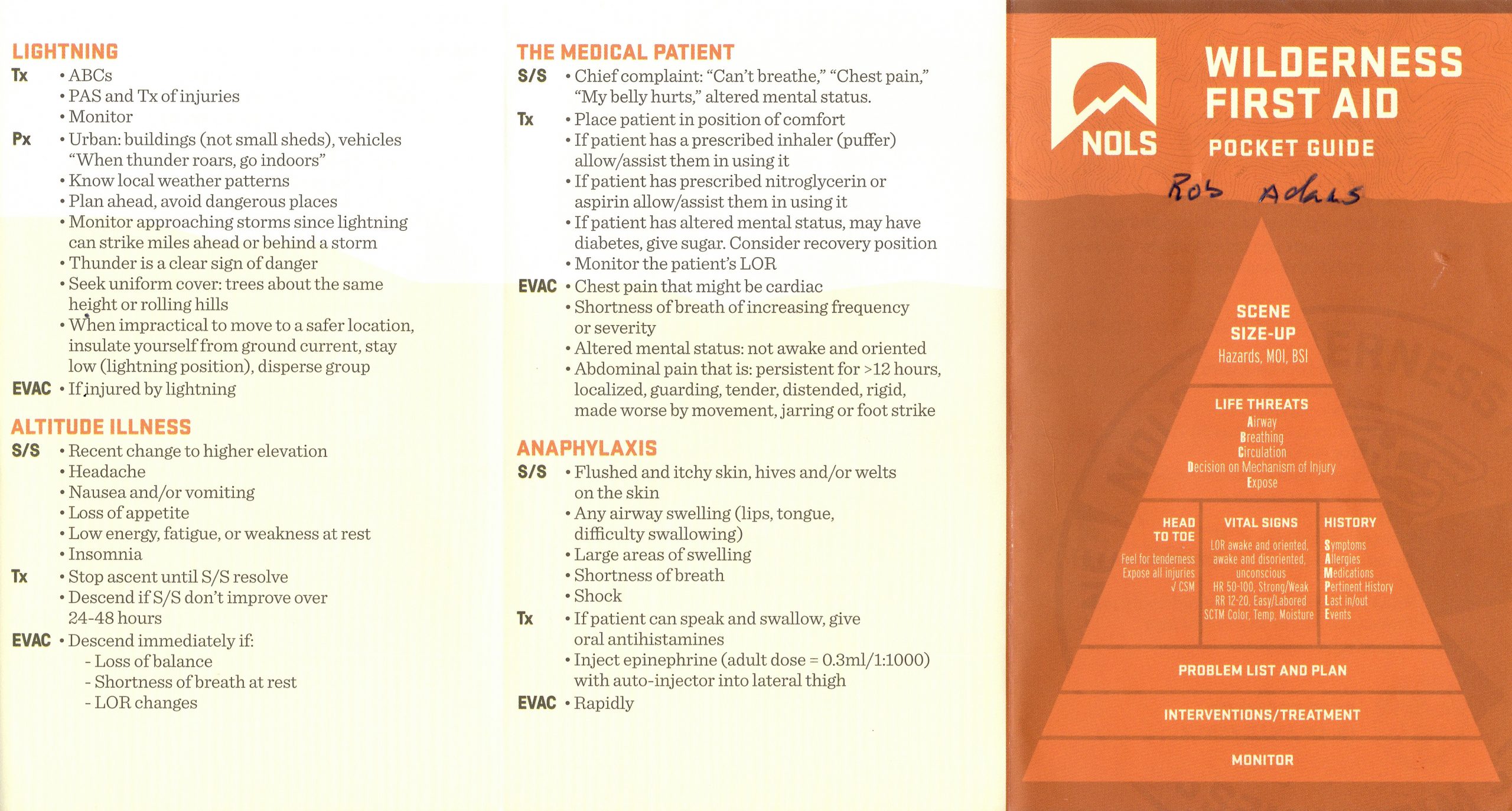
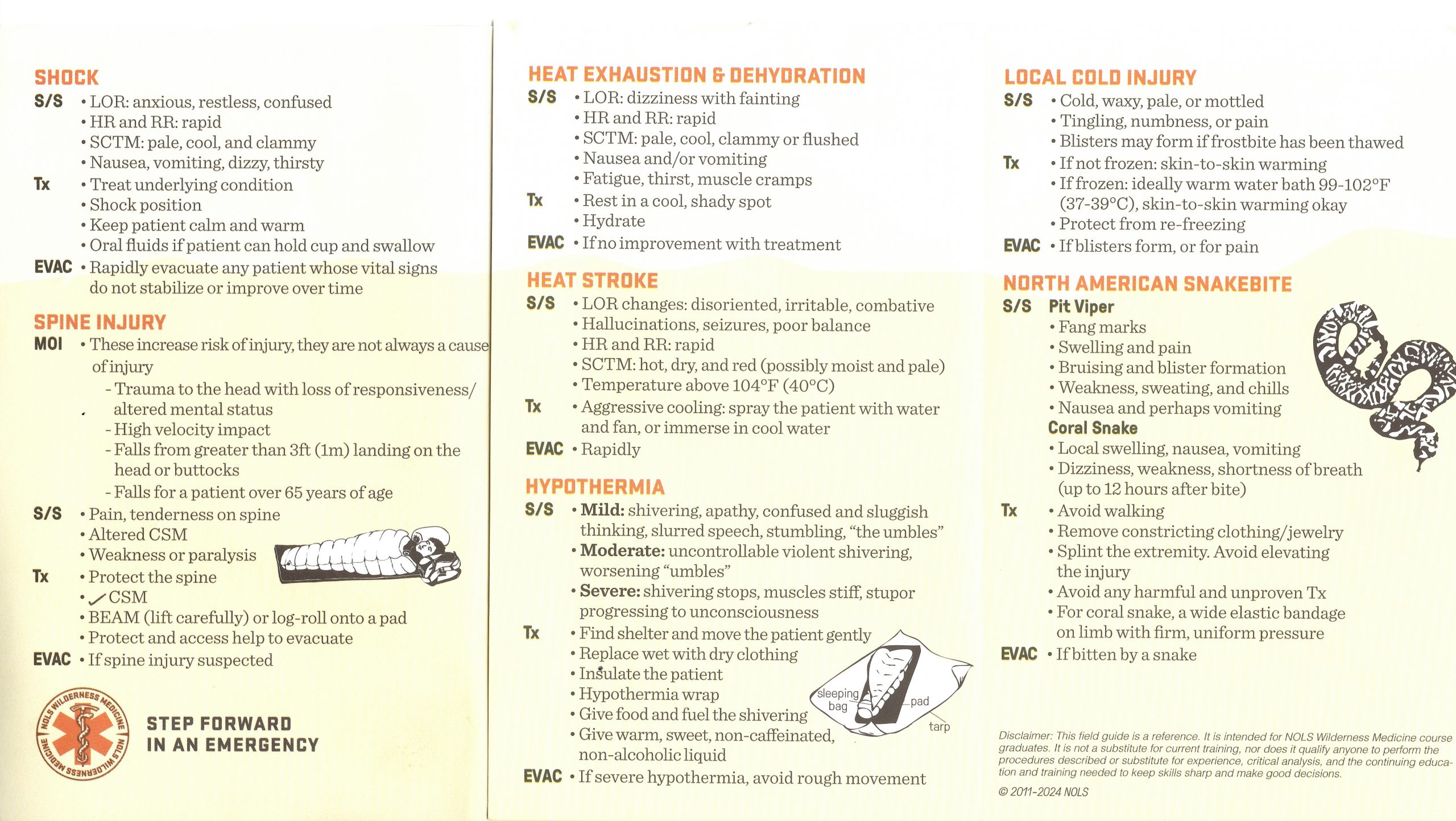
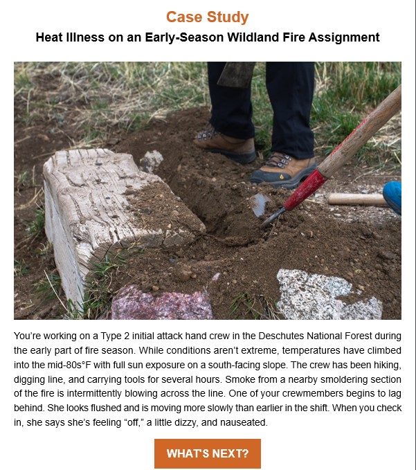 Case Study: Heat Illness on an Early-Season Wildland Fire Assignment – NOLS
The Setting
You are working on a Type 2 initial attack handcrew in the Deschutes National Forest during the early part of fire season. It’s one of the first assignments of the year, and while conditions aren’t extreme yet, temperatures have climbed into the mid-80s°F with full sun exposure on a south-facing slope.
The crew has been hiking, digging line, and carrying tools for several hours. Many members are new and this is the crew’s second week together. Smoke from a nearby smoldering section of the fire is intermittently blowing across the line.
Around mid-afternoon, one of your crewmembers, a 26-year-old female named Taylor, begins to lag behind. You notice she looks flushed and is moving more slowly than earlier in the shift. When you check in, she says she’s feeling “off,” a little dizzy, and nauseated. She also mentions her eyes are irritated from the smoke and that her contact lenses are bothering her.
You are the crew’s designated Wilderness First Responder (WFR). You decide to stop and perform an assessment.
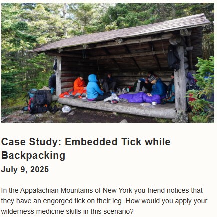 https://www.nols.edu/blog/case-study-embedded-tick-while-backpacking/
You’re on day 6 of a week-long backpacking trip on the Appalachian Trail in New York. The last few days have been beautiful, and you’re so glad to be enjoying this time outside. You and your friends decide it’s time for a break, so you sit down to enjoy some cool water and a snack. All of the sudden, one of your friends says, “Hey, I think there is a tick on me.” You wander over and offer to help out.
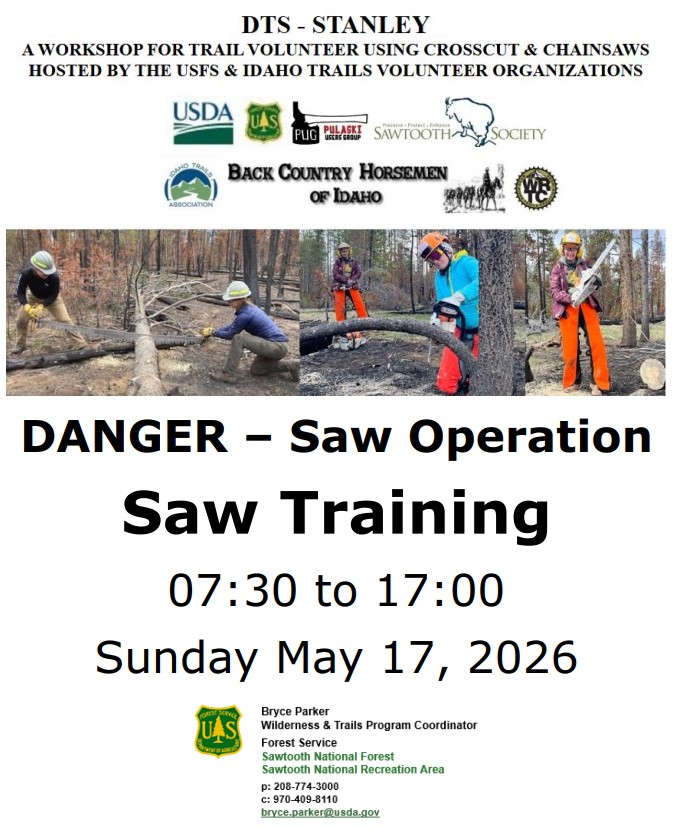
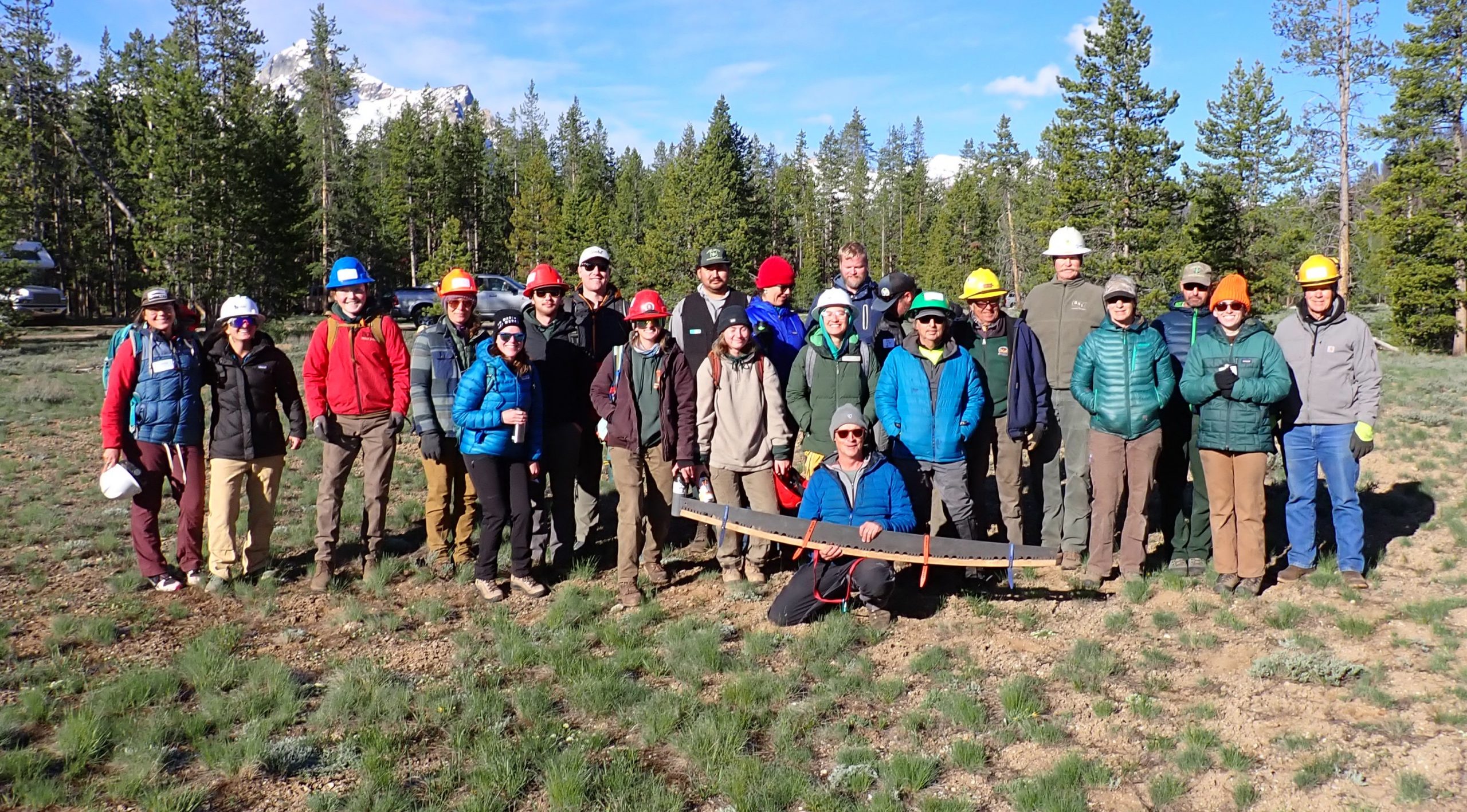
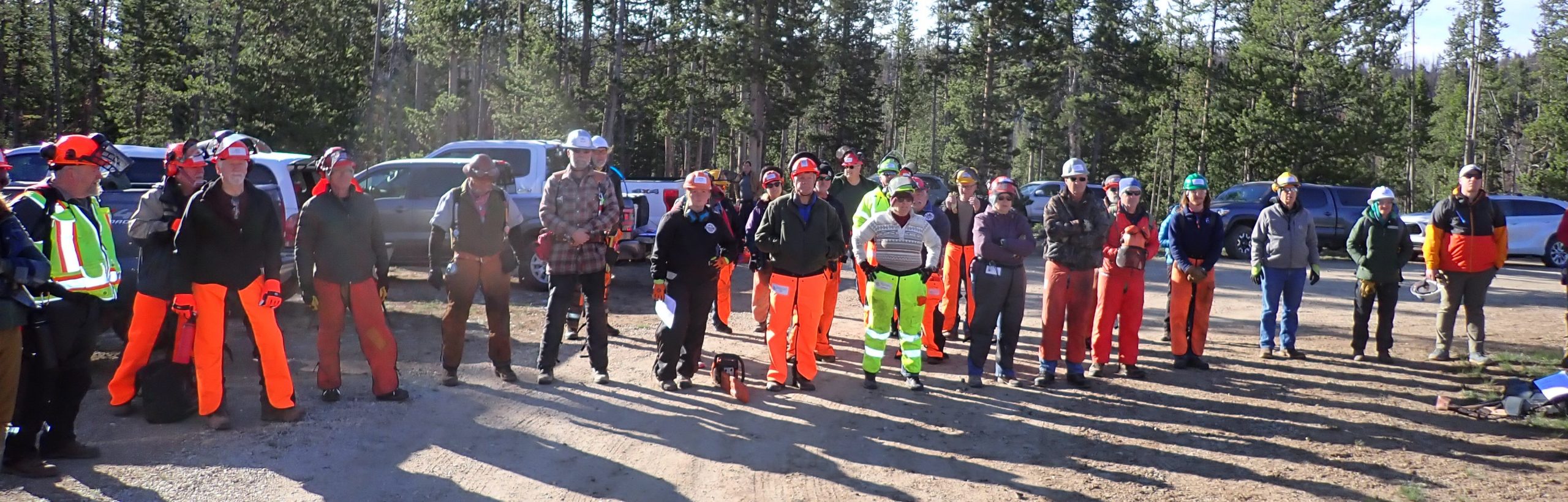
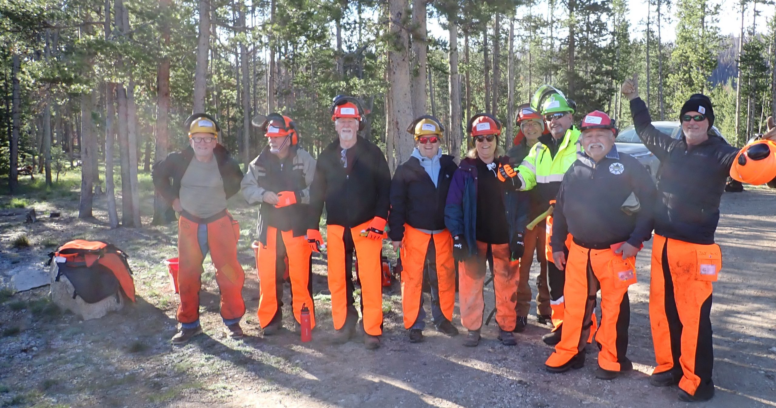
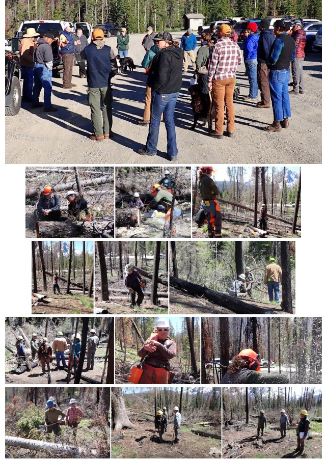
Wilderness & Trails Intern
Training, 5/18-5/22/2026
Nez Perce-Clearwater National Forests
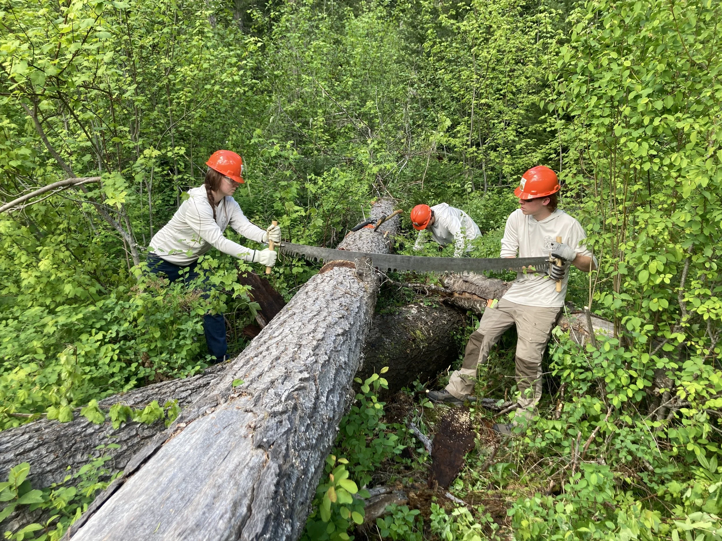
Two SBFC interns learning to use a crosscut saw at the NRWSI in May.
People of all backgrounds came together to attend the Northern Rockies Wilderness Skills Institute at the historic Powell Ranger Station along the Lochsa River, with at least one common interest: dedicating their summer to the conservation of public lands. Recognized for their continued dedication, people like Adam Washbeck, Regional Saw Program Manager for the United States Forest Service, and Todd Brown Backcountry Horsemen of Idaho, led the instruction of a budding workforce that has arrived for the season.
Josh and WTIntern, Darby, near completing the back cut on a large Grand Fir. In rising a little too high for their preferred stump shot, they learn just how much lift wedges can provide!
While the widespread use of chainsaws for logging evolved from the crosscut saw, the crosscut saw survives on a niche in wilderness conservation, cut out for itself by its primitive qualities. The Wilderness Act of 1964 deemed motorized use a threat to congressionally designated wilderness areas, sparing the non-motorized crosscut saw from extinction. Passing on the knowledge of how to use such a tool effectively in the field was critical. Commercial manufacturing of crosscut saws in America ceased during the 1950s. Therefore, the saws we hold in our hands are also relics that need to be maintained properly to ensure their preservation. Without them, the sprawling network of trails leading the public into wilderness would remain inaccessible, by trees that have yielded their position in the sky, but not on the ground, to any force other than a saw.
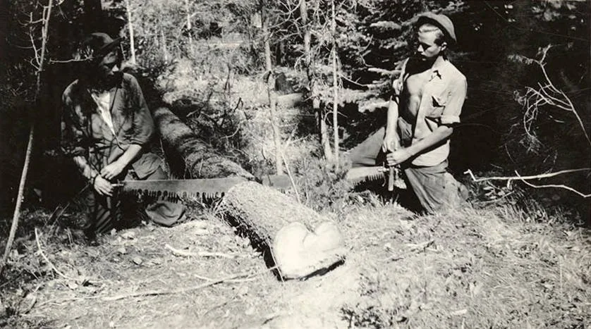
Two CCC men cross-cutting a log with a saw in 1939. (“CCC Men and Crosscut Saw”, Civilian Conservation Corps in Idaho Collection, University of Idaho Library Digital Collections, https://www.lib.uidaho.edu/digital/cccidaho/items/cccidaho1007.html”)
Webster, NY
SUNY: Geology
Andrew attended New York state college to study geology. Field courses required for professional licensure introduced Andrew to Montana for the first time. He is returning to Montana after trail maintenance for the SCA in the Adirondack Park as well as land stewardship for the Appalachian Trail Conservancy in Virginia.
This came from Backcountry Hunters and Anglers.
Friday night, the President signed an executive order that could fundamentally change public lands as we know them.
Decades of underlying policy allowing agencies to govern motorized vehicle use on federal land? Gone. Agencies have been directed to rescind or rewrite policy that has regulated ORV use on public lands for the past 50 years.
We, the BHA community, already know the implications: Unchecked motorized travel on public lands can harm access for everyone in the long run. It changes wildlife behavior, fragments habitat & trades the quiet for the noise.
Access matters & we fight for it every day. But access & motorization are NOT the same thing.
Not every acre of public land should be managed for maximum motorized access. The ability to reach public lands should not come at the expense of the wild qualities that make those places worth visiting in the first place.
We’re dissecting every detail of this order and continuing to advocate for the backcountry in the halls of Congress. More to come.
~~
The draft is to not allow any restrictions on motorized access to national forests, you can’t tell a motorcyclist they can’t ride there or stop ATV or UTV access to anywhere. They want to “open and improve” airstrips in the backcountry, the Big Creek 4 are right there on top of the list. They want to rewrite the wilderness act to allow chainsaws across the board, which opens the door for mechanized travel and motorized travel in Wilderness. That chainsaws in Wilderness push was just the foot in the door for eliminating what we know as big W Wilderness. Trump is piling this on faster than we can fight it. I am still involved in fighting the chainsaw thing and a lawsuit is being drafted, those folks that are OK with using chainsaws have just opened the door for the full on removal (or updating as IOGA calls it) of the Wilderness Act. Jeff Halligan
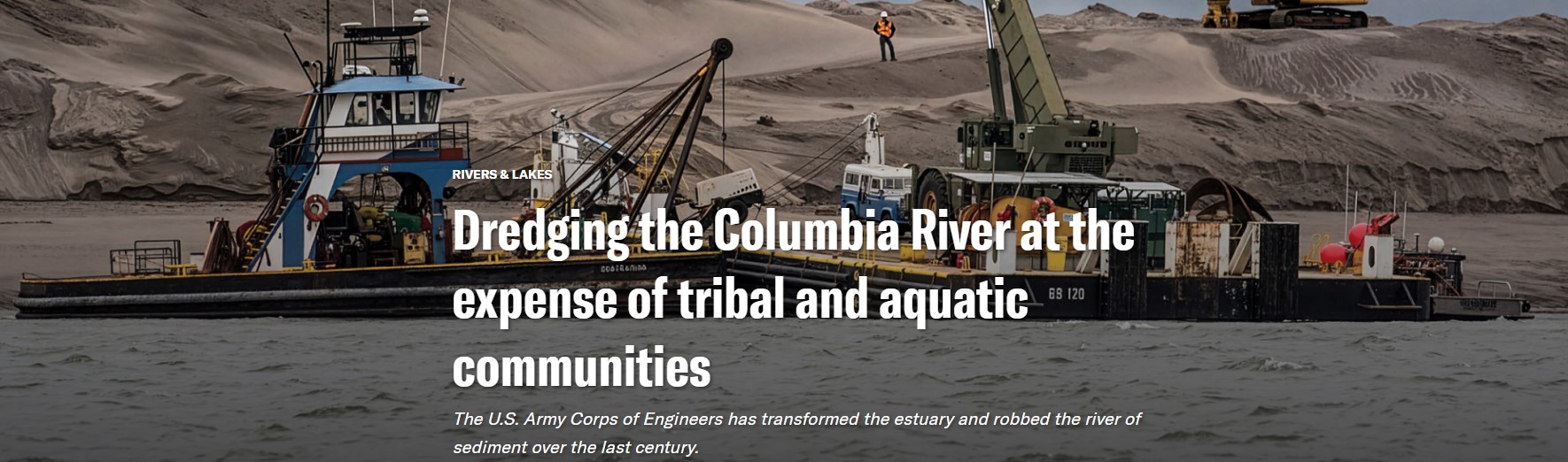
The story of people and the lower Columbia River has always centered around canoes. Varying shapes and styles were built to navigate the river’s varying shapes and elements. There were canoes for shallow water and deep water, canoes to cut through currents and travel upstream, canoes for clamming, fishing and whale hunting.
Chinookan canoe construction reflected the diversity of the region’s people and the lower Columbia, comprising a vast 146-mile estuary from the river’s mouth to the western Columbia River Gorge. The most famous and largest canoes measured up to 60 feet long, designed to navigate powerful wind and waves near the river’s mouth and big enough for three tons of people and cargo. Among the smallest were 10- to 14-foot canoes made for gathering wapato, a wetland plant with emerald, arrowhead-shaped leaves and edible potato-like tubers. The boats were sleek, light enough to carry under one arm and ideal for the slow-moving shallow waters around present-day Portland, where wapato thrived.
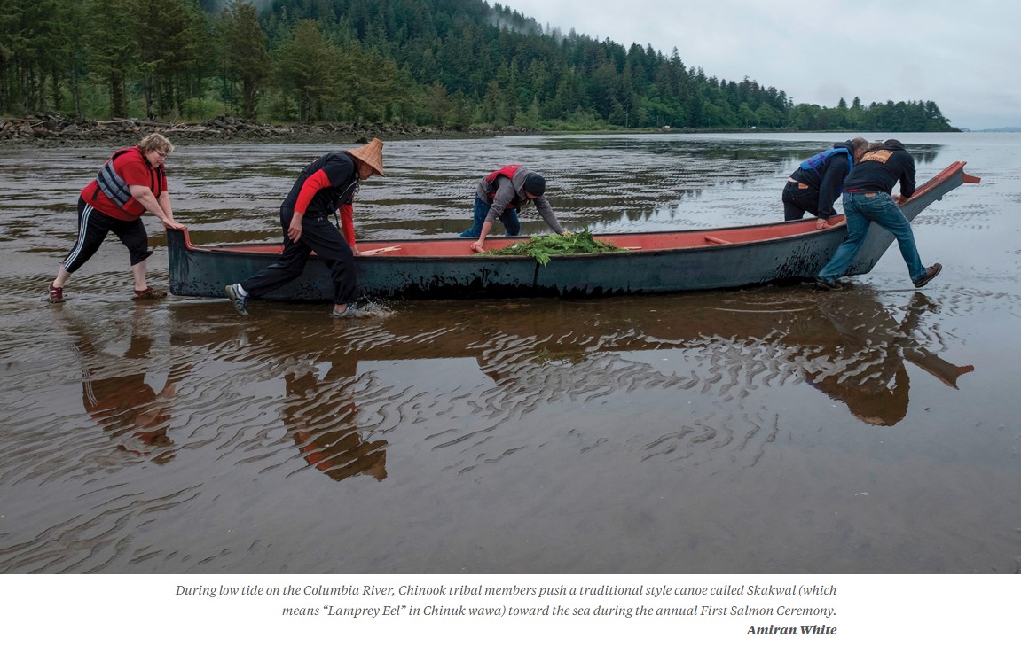 Canoes decorated the river’s sandy shorelines. Villages lined its banks. Before the 1800s, no levees separated the waterway from the floodplain. No dams blocked salmon. Cold water roared over rapids and sighed through the estuary. Braided channels thick with insects and songbirds curved through marshy bottomlands. Minnows, suckers and sturgeon filled the clear backwater tidal sloughs. These extensive channels snaked through the broad estuary like veins from the region’s heart, the Columbia, known as wimaɬ to upper Chinookan peoples and iyagaytɬ imaɬ to the lower Chinookans at the river’s mouth. The habitat supported one of the world’s largest salmon runs, when 10 to 16 million salmon and steelhead returned from the ocean to spawn in their ancestral rivers. Dredging the Columbia River at the expense of tribal and aquatic communities


May 29, 2026 – FOR IMMEDIATE RELEASE
Contacts:
Grant Stevens, Communications Director, Southern Utah Wilderness Alliance (SUWA); (319) 427-0260; grant@suwa.org
Washington, DC – Friday evening, in his latest attack on federal public lands, President Trump announced the repeal of Executive Order 11644 of February 8, 1972 (Use of Off-Road Vehicles on the Public Lands), and Executive Order 11989 of May 24, 1977 (Off-Road Vehicles on Public Lands). He further directed federal land management agencies including the Bureau of Land Management and Forest Service to rescind or revise their regulations implementing these Orders. Below is a statement from SUWA Legal Director Steve Bloch and additional information.
“The reality is that there are tens of thousands of miles of dirt roads and trails in Utah’s canyon country open today to motorized vehicles. Far from motorized vehicles being kept out of public lands, it’s quite the opposite: it’s the wildlife and visitors trying to picnic or camp with their families that are being chased out at every turn,” said Steve Bloch, Legal Director at the Southern Utah Wilderness Alliance (SUWA). “These executive orders provided the foundation for common-sense management of motorized vehicles on public lands. They recognized the destructive impact unmanaged motor vehicles have on our public lands and required federal agencies to minimize the damage. The impacts of today’s Order will be significant, long-lasting, and devastating.”
About Executive Orders 11644 and 11989
Presidents Nixon and Carter issued Executive Orders 11644 and 11989 in 1972 and 1977, respectively, in response to the growing use of dirt bikes, snowmobiles, all-terrain vehicles, and other off-road vehicles (ORVs) and corresponding environmental damage and conflicts with non-motorized recreationists. These executive orders require federal land managers to plan for ORV use to protect resources and other recreational uses. Specifically, the executive orders require that, when designating areas or trails available for ORV use, the agencies locate them to:
(1) minimize damage to soil, watershed, vegetation, and other resources of the public lands;
(2) minimize harassment of wildlife or significant disruption of wildlife habitats; and
(3) minimize conflicts between off-road vehicle use and other existing or proposed recreational uses of the same or neighboring public lands.
SUWA Statement on President Trump’s Repeal of Travel Management Executive Orders – 5.29.26
The Sawtooth National Forest will be implementing a couple new communication tools to keep stakeholders informed about what’s happening on the Forest now and what’s on our horizon.
We are so excited to be sharing this email through a new subscription email distribution system. Aside from being able to share what’s happening on the forest with stakeholders directly, the best part of this system is that stakeholders control whether or not they continue to receive these updates. Subscription and personal profiles can be managed in the footer of this email.
New users can subscribe for these updates themselves on our Keep in Touch webpage. We do want to warn those who choose to share these emails with others that each distributed email is tied directly to a specific email and profile. So, if you share the email with someone who doesn’t want to continue receiving updates, they may unintentionally unsubscribe you from our lists thinking they are doing it for themselves. To avoid this confusion, we will, as much as possible, put the bulk of the the content we want to share on our website so you can alternatively share the website addresses to the main content.
 Over the past few weeks, we’ve been bombarded with questions about SBFC’s position on the recent signing of the Minimum Requirements Analysis for chainsaw use on certain trails in the Frank Church- River of No Return Wilderness.
SBFC is a wilderness stewardship organization with “Frank Church” in our name, so people naturally want to know our stance and what “side” we are on. The us-vs.-them narrative on this subject, and so many others in our country, can be incredibly strong.
SBFC has never been about us vs. them. We are a non-advocacy, boots-on-the-ground stewardship organization. We recruit hundreds of volunteers and hire dozens of seasonal staff and interns each year to get an incredible amount of work done in the Selway-Bitterroot, Frank Church, and surrounding wildlands. One of our strengths is that we won’t play into the us-versus-them narrative. It’s not what we do.
But, for those wondering, what is SBFC’s position on this “in the news” topic? Here it is: SBFC is a wilderness stewardship outfit. We do a ton of work on trails. We estimate that SBFC crews will maintain 600-1000 miles of trail under our current plans this season. It’s a tremendous amount of work.
SBFC crews will use traditional tools while working in the wilderness this season, just as we have for the last twenty years. Our crews are experienced and skilled with crosscuts and axes, and they’ll remove 5,000-10,000+ logs from the trail corridor this season with those tools, skills, and passion.
SBFC wilderness trail crews do more than just remove logs. We forecast that our crews will likely spend 30-40% of their time cutting logs this season. Tread repair and drainage work has become an increasingly large part of what our crews do. This work is not optional; it truly sustains the resource. Brushing (no one’s favorite job) is equally important for the long-term sustainability of the trail. You can be sure we’ll be doing a whole lot of this work, in addition to cutting out thousands of logs.
All of this is to say, SBFC is laser-focused on wilderness stewardship. For us, wilderness stewardship means we’ll be using traditional non-motorized / non-mechanized tools when working in the wilderness, whether removing logs from the 8 ft wide trail corridor, removing brush, kicking rocks off the tread, or repairing the tread itself, which is a highly technical, skilled task where there are no shortcuts to doing good work.
No matter the tool or task, it takes an incredible amount of human time, effort, and skill to accomplish wilderness and trail stewardship goals across this landscape. It takes more humans than we have had out there in recent years (or decades). So, we will focus on bringing more humans into the fold and out on the ground. In 2026, we have our largest ever cohort of seasonal staff and interns (34!), and not by a small margin. We’ll engage with the most adult and youth volunteers in our history, and again, not by a small margin. We can see the energy, the excitement, and the momentum. It is real. Those are the things that we need, and those are the things that stand the test of time as we look ahead, not just for the next few years, but for decades to come.
SBFC exists because people love wilderness, and people care about these places a whole lot. We can say with confidence that many people will continue to love and care about these places far into the future.
Our mission is to open pathways for all to discover and steward wilderness. Stewarding wilderness is hard. It’s especially hard in the largest wilderness in the lower 48. What a privilege it is to play our role in this endeavor and to do it well. You can find us out there this season, from Missoula to Boise, and all points between, working to keep the wildest place accessible.
As always, feel free to reach out with thoughts, questions, or comments!
Wilderness Forever & For Everyone,

| As a side and stomach sleeper, I despise mummy-style sleeping bags. I always feel too confined, and, in the morning, my hip flexors are tight and sore. For a long time, I thought that was my cross to bear as a backpacker who wanted a lightweight bag, until I found NEMO’s Disco 15 Sleeping Bag ($300). |
| The Disco 15 has a more generous, roomy fit than a typical mummy bag, with what NEMO calls a “spoon shape.” There’s extra space for my elbows and knees, allowing me to roll around and splay out in comfort. |
| While it’s not ultralight at 3 pounds, 5 ounces, the bag is certainly light enough to bring on a week-long backpacking trip. |
| Perhaps most importantly for camping/backpacking gear, this bag is durable. I’ve had it for 5 years, and it’s seen everything: mud, sweat, and my dogs (and their vomit). When I snuggle up in the Disco 15 to go to bed, I’m just as warm and cozy as I was on night 1. |
| Product score: 7.9/10 |
The U.S. Forest Service has granted a rare exemption allowing the use of chainsaws in one of the country’s largest wilderness areas.
The agency on Wednesday approved a request from the Idaho Outfitters and Guides Association to temporarily use gas-powered chainsaws to clear about 542 miles of trails in the Frank Church-River of No Return Wilderness, citing “extraordinary levels” of downed trees. The Frank Church, in central Idaho, is the largest contiguous wilderness area in the lower 48 states.
“This action is necessary to restore safe public access while minimizing impacts to wilderness character and remaining fully compliant with the Wilderness Act of 1964,” Amy Baumer, a spokesperson for the Salmon-Challis National Forest, wrote in an email.
Trail crews typically rely on hand tools such as crosscut saws in designated wilderness areas, which are among the most protected public lands. The Wilderness Act prohibits motorized vehicles and equipment to protect places “untrammeled by man” and to preserve “solitude.”
These exclusions have long been interpreted to include chainsaws, though the Forest Service grants occasional exceptions, usually after wildfires or major storms.
But the Idaho Outfitters and Guides Association (IOGA) petitioned the agency last year, arguing that decades of wildfire and disease have created an unmanageable buildup of fallen trees. A Forest Service survey last year estimated between 80,000 and 110,000 trees lying along one 150-mile stretch in the Frank Church.
“Almost half the trails in this wilderness area on the Salmon-Challis are unusable,” said Erik Weiseth, the executive director of IOGA. “Over time, they will just be overgrown and disappear. That is not only hurting our outfitter members, but it’s also hurting the general public. It’s hurting their ability to access the wilderness.”
Weiseth said the blockages have meant lost business for outfitters who can’t get to the spots where they’re authorized to run hunting or guided horseback trips. Volunteers and a shrinking Forest Service workforce have struggled to keep trails open with hand tools, he said. He also pointed to language in the law specific to the Frank Church wilderness, which directs the agency to clear trails annually “to the maximum extent practicable.”
In a letter on Wednesday, the nonprofit Wilderness Watch asked the Forest Service to delay implementation until 2027 to allow time for judicial review “before the wilderness is overrun with chainsaws.”
George Nickas, the executive director of the Missoula-based organization, called the authorization “just blatantly illegal” and said the organization is considering legal action.
“Getting in there with chainsaws to clear all these trails – it’s all about domination. It’s all about our controlling what’s going on there, our wanting to change the character of the wilderness to meet our demands,” he said. “That’s just the antithesis of what the Wilderness Act is all about.”
The group said it learned of discussions between IOGA and Forest Service officials, including Chief Tom Schultz who is from Idaho, through public records requests. It criticized the agency for not allowing public comment before the approval.
Nickas said the decision could have implications beyond Idaho. Public records reviewed by the group indicated outfitters in Wyoming asked the agency to allow battery-operated chainsaws for trail maintenance.
In 2019, the Forest Service approved chainsaw use in two wilderness areas in Colorado. Conservation groups including Wilderness Watch sued, and the agency later withdrew the proposal.

The authorization by the Forest Service in the Frank Church allows licensed outfitters to use chainsaws for three years from Jan. 1 through Aug. 1 each year.
Weiseth said that by Wednesday afternoon, authorized outfitters were already in the forest clearing logs.
“This is a big deal to these guys. They’ve been wanting to get some of these trails open for a decade or more,” he said. “They threw their stuff in the truck and started driving to the woods, ready to go.”
This story was produced by the Mountain West News Bureau, a collaboration between Wyoming Public Media, Nevada Public Radio, Boise State Public Radio in Idaho, KUNR in Nevada, KUNC in Northern Colorado, KANW in New Mexico, Colorado Public Radio, KJZZ in Arizona and NPR, with additional support from affiliate newsrooms across the region. Funding for the Mountain West News Bureau is provided in part by the Corporation for Public Broadcasting and Eric and Wendy Schmidt.
For Immediate Release: Tuesday, May 12, 2026
Contacts:
John Robison, Idaho Conservation League, (208) 345-6933 x 213
Nick Kunath, Idaho Rivers United, (208) 908-9232
Fred Coriell, Save the South Fork Salmon, (208) 315-3630
Jared Naimark, Earthworks, (650) 213-8052
Marc Fink, Senior Attorney, Center for Biological Diversity, (218) 464-0539
Boise, ID — A coalition of local and national conservation groups filed a motion preliminary injunction last Friday to halt Perpetua Resource’s pending construction of the Stibnite Gold Project: an open-pit cyanide leach gold mine in the headwaters of the South Fork of the Salmon River. The motion asks to halt construction of the mine on public lands, including constructing a new access road cutting through Idaho’s Salmon River Mountains, in order to protect the environment and “threatened” species.
In February 2025, the conservation groups filed suit in federal district court against the U. S. Forest Service for violating the National Environmental Protection Act and other bedrock environmental laws in approving the mine, which would be located mostly on National Forest lands. The lawsuit is also against the U.S. Fish and Wildlife Service for violating the Endangered Species Act by failing to protect threatened bull trout, wolverine, and whitebark pine. The Forest Service’s own analysis shows that the project area would not be restored as Perpetua claims but would actually be worse off if the project proceeds—even if the proposed restoration work goes perfectly according to plan.
Last fall, the conservation groups and Perpetua reached an agreement allowing limited pre-construction activities to occur while the lawsuit was being briefed. Briefing concluded earlier this year (see “Case Filings” here). Perpetua now seeks to commence “full construction” at the end of May, without waiting for a final decision from the Court.
Among other initial mine construction activities, Perpetua has indicated it will start constructing the Burntlog Route: a second and new access road to the mine site, through protected roadless and riparian areas and threatened species habitat. Perpetua would reconstruct and widen 23 miles of existing road on National Forest to be approximately four times wider than standard roads in the area to accommodate industrial mine traffic. To complete the Route, Perpetua would also build 15 miles of new road through remote wildlife habitat, mostly in inventoried roadless areas.
“The South Fork Salmon River and everything and everyone who depends on it are at risk if the government allows our public lands to be monetized to benefit billionaires,” said John Robison, Public Lands and Wildlife Director for the Idaho Conservation League. “We believe the South Fork Salmon River deserves its day in court before Perpetua Resources and its financiers rush ahead and make irreversible changes to this special area.”
The Stibnite site is 45 air miles from McCall, Idaho, adjacent to the Frank Church–River of No Return Wilderness Area and is within the homelands of the Nez Perce Tribe. Perpetua’s massive mine plan entails excavating three open pits. It would create 280 million tons of waste rock and include constructing a 475-foot tall, 120-million-ton tailings storage facility—more than 1.5 times taller than the Statue of Liberty. One of the open pits would extend more than 720 feet beneath the riverbed of the East Fork South Fork Salmon River. Perpetua would also build an extensive web of roads, power lines, and other industrial infrastructure across public lands to reach the remote mine site.
“We’re seeking to prevent this special part of Idaho from being irreversibly damaged before the legal process has run its course,” said Bryan Hurlbutt, staff attorney at Advocates for the West and counsel for the conservation groups. “Our preliminary injunction motion asks the Court to preserve the status quo until it issues a final ruling in the lawsuit.”
“Rushing to construct the mine is just one more instance of Perpetua putting its profits first, instead of being the ‘good neighbor’ the company pitches to the community,” said Judy Anderson of Save the South Fork Salmon.
“In light of Perpetua’s push to begin full construction, court intervention is necessary to protect critical habitat in the South Fork Salmon watershed from damages that simply cannot be undone,” said Nick Kunath, Conservation Director at Idaho Rivers United. “This watershed and all that it provides deserves much more than allowing Perpetua to plow forward with damaging activities before the case before the court has had a chance to be resolved.”
“The rush to make a profit is not more important than the law,” said Jared Naimark, Western Mining Senior Manager at Earthworks. “Legal protections exist to ensure the South Fork of the Salmon River, our National Forests, and the animals that call these lands and waters home are taken care of for generations to come. The proposed Burntlog route is an unlawfully approved second access road. It would damage protected roadless areas and streams and harm endangered wolverine and bull trout. Perpetua Resources must not construct the road before the courts have decided whether the project is allowable. That damage can’t be undone once it happens.”
###
Save the South Fork Salmon strives to protect and preserve the ecological, cultural, and economic resources of the South Fork of the Salmon River watershed and the well-being of the people that depend on them for generations to come.
www.savethesouthforksalmon.com
Idaho Conservation League’s mission is to create a conservation community and pragmatic, enduring solutions that protect and restore the air you breathe, the water you drink, and the land and wildlife you love.
Advocates for the West is a non-profit, public interest environmental law firm headquartered in Boise, Idaho, that works to defend public lands, water, fish and wildlife throughout the American West.
Idaho Rivers United’s mission is to protect and restore the rivers and fisheries of Idaho, and is the only conservation organization in the state focused exclusively on the health and protection of river resources.
Earthworks mission is to protect communities and the environment against the adverse impacts of mineral and energy development while seeking sustainable solutions.
The Center for Biological Diversity is a national, nonprofit conservation organization with more than 1.7 million members and online activists dedicated to the protection of endangered species and wild places.
American Rivers is championing a national effort to protect and restore all rivers, from remote mountain streams to urban waterways.
By now, you’ve likely seen local, regional, western, and national coverage of the Trump administration’s plan to reorganize the Forest Service.
The proposal includes moving the agency’s headquarters from Washington, D.C. to Salt Lake City, eliminating the 9 Regional Offices, establishing 15 new State Offices (including one in Boise), setting up a network of Service Centers, and consolidating 77 Research Centers into as few as 20.
Hundreds of conservation groups and outdoor companies are sounding the alarm, warning that the Forest Service is essentially being dismantled. In response, the Forest Service itself took the unusual step of releasing a “Myth vs. Facts” statement in an attempt to push back on that narrative.
Several retired Forest Service supervisors describe the proposal not as a dismantling but as a “flattening” of what they see as a top and middle management-heavy (muffin-topped) organizational structure. In their view, the changes could ultimately be beneficial—reducing costs, improving efficiency, and helping staff get more work done. The Forest Service Chief also noted that no changes would be made until after this year’s wildfire season.
Still, the massive pushback against the reorganization (“Blink twice if you are being kidnapped, Smokey”) reflects a far deeper concern: many people who value public lands see this as part of a broader pattern—one that could ultimately lead to weakening protections and selling off public lands.
Currently, North Idaho forests are managed out of the Region 1 office in Missoula, Montana, while south Idaho forests are managed out of the Region 4 office in Ogden, Utah. Replacing regional offices with state offices could make sense—if done thoughtfully. The Bureau of Land Management (BLM) already uses a state-based structure with reasonable success, but that model depends on adequate staffing and resources.
However, as currently envisioned, the Forest Service State Offices would be staffed by only a handful of employees and would lack the full complement of Regional staff who have special expertise in mine engineering, forest pathogens, cultural resources, and Treaty Rights, and more. While the newly proposed Service Centers could house some of these experts, that is not stated in the current plan. The result could be further loss of institutional knowledge when we can least afford it.
While maintaining local District Ranger and Forest Supervisor offices makes sense for working with local communities, the Forest Service leadership also needs to engage directly with members of Congress and other federal agencies in critical matters like budgeting and coordination. Key decisions are made in D.C, not Salt Lake City. A reduced presence there could leave the Forest Service at a distinct disadvantage. As the saying goes, “If you’re not at the table, you’re on the menu.” A diminished Washington office might lead to reduced funding, staffing, and ability to keep the Forest Service intact.
One of the biggest risks is the loss of staff with critical institutional knowledge. When the last Trump administration moved the BLM’s headquarters from Washington, D.C. to Grand Junction, Colorado, hundreds of employees retired or left their jobs rather than relocating. These people never came back. The move didn’t result in savings but instead a significant loss of expertise.
We have the same concerns here. To make matters worse, the Forest Service is already dealing with staffing gaps following last year’s senseless, chaotic and illegal DOGE-related cuts. While some staff were hired back, many were not. This reorganization could exacerbate those losses. Furthermore, Congress is not being consulted about this reorganization.
Forest Service research stations collect critical data on watersheds, fisheries, wildlife, forest health, and silviculture, among many other topics. Consolidating or closing these stations raises serious concerns (“It’s just madness”)—especially if long-term study sites and datasets are abandoned in the process. These Stations are essential in generating applied research which is essential for preparing for disasters and guiding restoration. Weakening them now is a step in the wrong direction.
While ICL has questions about the real intent behind the reorganization, the more troubling issues arise over changes in priorities, policy, and by extension, land management—particularly around public review of proposed projects.
The Forest Service argues that this reorganization will move decision-makers closer to the public so the agency can better serve them. However, at the same time, recent changes to NEPA regulations reduce or remove opportunities for the public to learn about and provide input on Forest Service activities. So while decision makers may be geographically closer to you, they are now no longer allowed to host public comment periods for the majority of the projects affecting Idahoans.
This reality is already playing out. Take the Upper Bigwood Vegetation Management Project near Galena in the Sawtooth National Recreation Area for example. This 2,500-acre proposed project—in a landscape that is highly visible, well used, and well loved—would typically be analyzed through an Environmental Assessment (EA) with scoping and comment periods. These public comments provide community members with meaningful opportunities to shape the project,helping to optimize treatment activities and minimize negative impacts. In the past, the Forest Service has made substantive project improvements as a result of public comments. However, under the new regulations and the new Emergency Authorization, this project is proceeding without an official public comment period (there is an open house on May 11). That represents a significant shift away from public participation.
The Forest Service isn’t dead…at least not yet. The Ranger Districts, Forests and Forest Supervisor offices are all still here. The agency even hired seasonal staff for trail work. And citizen-led forest restoration collaboratives like the Boise Forest Coalition continue to connect communities to the Forest Service. But the reform the agency truly needs isn’t the proposed “structural overhaul”—or preparation for disintegration—but a restoration of the funding and adequate staffing to fulfill its mission: “Caring for the Land and Serving the People.”


Breathing Issues
If your chainsaw is losing power, bogging down, or struggling to rev, the issue might be simpler than you think.
A common but overlooked culprit is a clogged exhaust.
Over time, carbon buildup can restrict airflow through the muffler or spark arrestor screen. When exhaust gases can’t escape, your engine can’t breathe—and performance suffers.
What causes it?
Running rich fuel mixtures, low-quality oil, or long periods of idling can all lead to carbon buildup.
How do you know?
Look for these signs:
• Loss of power under throttle
• Bogging or poor acceleration
• Excessive smoke
To fix it, remove the muffler cover and check the spark arrestor screen. If it’s coated in carbon, clean it by:
• Brushing off buildup
• Burning it off safely
• Replacing it if needed
Also, inspect the muffler outlet for deposits and clean as necessary.

Also, inspect the muffler outlet for deposits and clean as necessary.
Restoring airflow can quickly bring back lost performance. Before jumping into major repairs, check the basics first.
If you need replacement parts, we’ve got you covered.
Stay safe, and keep cutting smart. Sawzilla Parts <info@sawzillaparts.com>
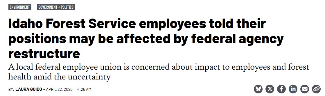
The recently announced major restructure of the U.S. Forest Service may disrupt a number of forestry positions in Idaho. But the details as to how those positions will be affected and what work will continue or be eliminated under the plan remain unclear.
Anna Webb, an entomologist and federal employee union representative based in Boise, received a notice about two weeks ago that her position in the agency would be affected. The letter said affected employees may have to move, find another position within the federal agency, or resign.
There was no expected timeline to the changes.
“It makes things difficult to plan,” Webb said, speaking to the Idaho Capital Sun in her capacity as a union representative. “It causes unprecedented amounts of stress.”
Leaders of the federal employee union that represents Forest Service employees for the Boise, Payette, Salmon-Challis and Sawtooth national forests are concerned about the disruption to local employees as well as the potential long-term consequences to forest health. READ MORE: 2026-04-22 USFS Restructure
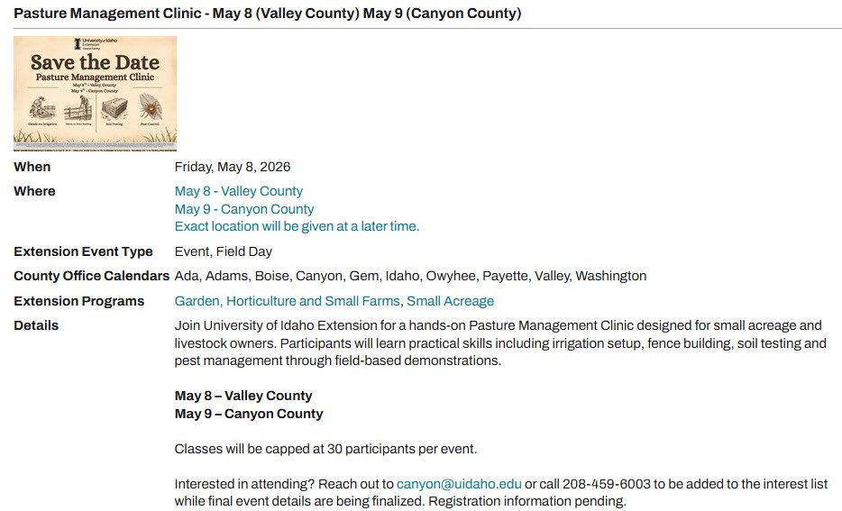
I thought this clinic (below) may be of interest to your chapter members as we head into spring.
Sincerely,
Karen Bailey
208-849-3474
Education chairman
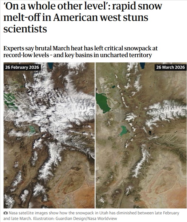 Snow surveys taking place across the American west this week are offering a grim prognosis, after a historically warm winter and searing March temperatures left the critical snowpack at record-low levels across the region.
Experts warned that even as the heat begins to subside, the stunning pace of melt-off over the past month has left key basins in uncharted territory for the dry seasons ahead. Though there’s still potential for more snow in the forecast, experts said it will probably be too little too late.
“This year is on a whole other level,” said Dr Russ Schumacher, a Colorado State University climatologist, speaking about the intense heat that began rapidly melting the already sparse snowpack in March. “Seeing this year so far below any of the other years we have data for is very concerning.”
Acting as a water savings account of sorts, snowpacks are essential to water supply. Measurements taken across the west during the week of 1 April are viewed as important indicators of the peak amounts of water that might melt into reservoirs, rivers and streams and across thirsty landscapes through the summer. READ MORE
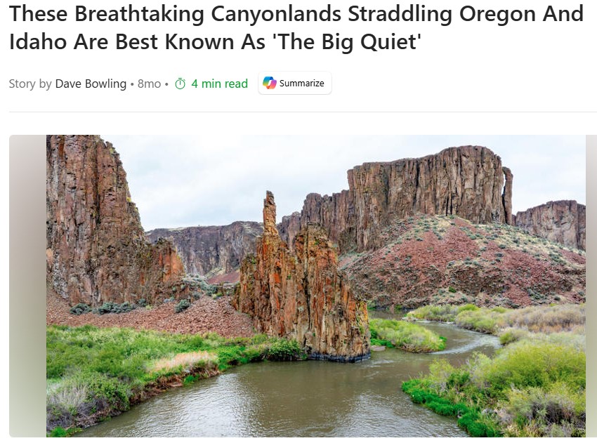
For many travelers, a summer adventure means photographing or traversing some of Mother Nature’s incredible works of art. Unfortunately, many of the iconic National Parks are so crowded that they require reservations in advance. If you’re looking for challenging hikes, excellent fishing, breathtaking canyon views, and epic whitewater without the crowds, consider the spectacular Owyhee Canyonlands, locally known as “The Big Quiet.” This largely untouched area covers nearly 9 million acres of Eastern Oregon, Southwestern Idaho, and Northern Nevada, beckoning visitors with an incredibly diverse range of geologic features, desert life, and adventurous experiences.
As the Owyhee Canyonlands stretch for hundreds of miles, there are several points of entry. The closest major metropolitan area with an airport is Boise. If you’re flying in, you’ll need to rent a 4×4 with high ground clearance and drive nearly 90 minutes to get to the edge of the wilderness area. Double-check that your rental car agreement permits off-road driving, or consider a specialty company such as Ribik. READ MORE
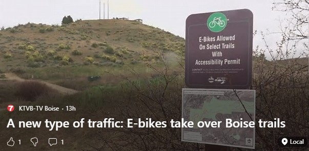
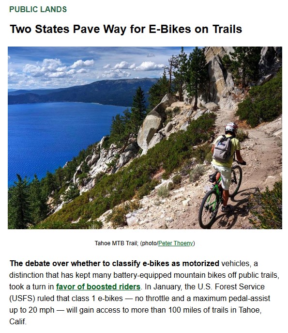
On a quiet foothills trail, the hum of an electric bike is becoming a more common sound.
E-bikes are growing in popularity nationwide and are increasingly showing up across the Ridge to Rivers trail system in Boise. But Trail Manager David Gordon says many riders are using them in places where they are not allowed.
Despite signage posted throughout the system, Gordon said riders continue to bring e-bikes onto nonmotorized trails.
“Even though we’ve got our trails signed everywhere, we’re finding people riding e-bikes all over the place,” Gordon said.
Under current federal guidelines, e-bikes are classified as motorized vehicles. Because of that, they are only permitted on two motorized trails within the Ridge to Rivers system: Eighth Street Motorcycle Trail No. 4 and Femrites Patrol Trail No. 6.
“They’re really still only allowed on our two motorized trails, because federally, they’re still classified as a motorized vehicle,” Gordon said.
Gordon said the technology allows riders to travel farther and access areas that may otherwise be difficult to reach, which can lead to unintended impacts.
He said a growing concern goes beyond traditional e-bikes to include electric motorcycles, which are heavier and capable of higher speeds.
“They’re heavier, they go a lot faster,” Gordon said.
He said many of the riders using electric motorcycles are younger, including junior high and high school students. Some of the bikes can reach speeds of up to 30 miles per hour, creating safety risks on narrow, multi-use trails.
“There’s lots of people out there — little kids, dogs, older people — anyone that can be out there not expecting something coming around like a little motorcycle at a high rate of speed,” Gordon said.
In addition to safety concerns, officials say the vehicles can cause damage when riders leave designated trails.
“Thirty miles an hour is not uncommon, and they’re heavier, and those are really a safety concern, as well as the fact that they can easily travel off trail,” Gordon said.
As the busy trail season approaches, Ridge to Rivers officials say enforcement and signage will continue, but they emphasize that protecting the system ultimately depends on users.
“It takes the community to manage our trail system,” Gordon said.
PDF: organizational-realignment-factsheet
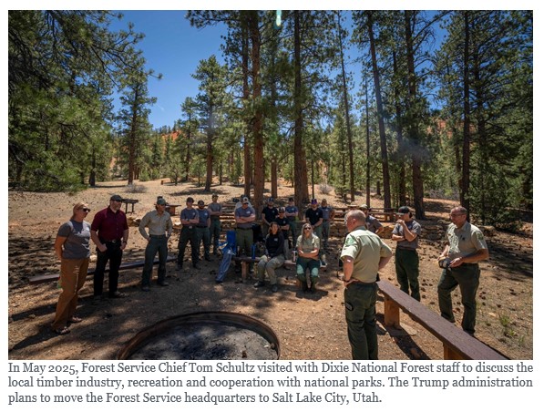 On March 31, the U.S. Forest Service announced plans to move its headquarters from Washington, D.C., to Salt Lake City, Utah. It will also close or repurpose all nine of its regional offices, create 15 state offices, and shutter research and development facilities in more than 30 states. According to a news release, the plan is intended to make the agency more “nimble, efficient [and] effective.” Forest Service leaders told staff on a call after the announcement that no changes will be made to fire and aviation management programs or field-based operational firefighters.
Since first announcing its intent to reorganize the agency last July, the Trump administration has marketed the plan as a way to streamline Forest Service operations, with a focus on boosting timber production and communicating more closely with local communities. But during a congressional hearing and public comment period on the subject last summer, more than 80% of the 14,000 public comments submitted were negative, with many tribal representatives, conservation groups and former Forest Service staffers opposing the move. A U.S. Department of Agriculture summary of public comments included concerns that relocating Forest Service staff and further cuts to its budgets “could compromise ecological management, public access, and employee morale.” The current plan incorporates many elements of the original proposal, including the move to Salt Lake City and the closure of regional offices.
“Nobody is asking for this,” said Robert Bonnie, who oversaw the Forest Service as a Department of Agriculture undersecretary during the Obama administration. “None of the farm groups want this. No one in conservation wants this. Nobody.” To Bonnie and other former Forest Service staff, the plan, which will uproot thousands of employees, looks like it will only make the agency’s existing troubles worse, especially given the past year of deep cuts and chaos.
“This is not going to strengthen the Forest Service, it is going to weaken it,” Bonnie said. “It’s not about solving problems, it’s about blowing things up.”
MARY ERICKSON, a retired Custer Gallatin National Forest supervisor, had more questions than answers after the announcement. “I’m not going to say if it’s good or bad at this point,” she said. “It’s just such a sweeping change with no real analysis about if there would be cost savings.”
Under the new proposal, some states will have their own offices and others will be lumped together, similar to the organization of the Bureau of Land Management. This will be a new approach for the country’s 154 national forests, which have long been managed by the nine regional offices that will be shuttered or repurposed. Now, forests in Washington, Oregon, Montana, Alaska and Idaho will each be managed by their own state office. Forests in Nevada and Utah, however, will be managed together, as will forests in Colorado and Kansas.
Some Forest Service research facilities, including the Rocky Mountain Research Station in Fort Collins, Colorado, will stay open. Others, including the research station in Portland, Oregon, which is responsible for critical work on species like spotted owls, will be closed. Losing local leadership “is not going to improve the programs,” said former Forest Service wildlife biologist Eric Forsman. Forsman, who retired in 2016, studied spotted owls and red tree voles at the agency’s Forestry Sciences Laboratory in Corvallis, Oregon, which will remain in operation. “It may help budgets,” he added, “but it won’t improve the quality of the research or the amount of research that gets done.”
Erickson and others were also concerned about the plan to move high-level bureaucrats out of D.C., where the nation’s law- and policymakers reside. “I would push back on this idea that moving out of D.C. is moving closer to the people you serve. That’s not the role of the national office,” Erickson said. The national office, she added, is supposed to coordinate and create guidance based on national policy. “Forests and districts have always been the heart of local communities and local delivery.”
After talking with current and former Forest Service staffers following Tuesday’s announcement, she also worries that, at least in the short term, disarray created by the reorganization will hamstring the agency’s ability to address the complex and worsening challenges that modern forests face. Those include tree disease outbreaks, the growing wildland-urban interface and climate change-induced drought. The Forest Service is already reeling from the loss of thousands of employees during the last year, through the terminations and deferred resignations effected by the now-defunct Department of Government Efficiency, or DOGE.
The reorganization may also lead to states playing an even bigger role in forest management, said Kevin Hood, executive director of Forest Service Employees for Environmental Ethics, who retired in 2025 after decades working in the Forest Service throughout the West. While local coordination isn’t bad in theory, he said, he’s concerned the new structure will be a step toward ceding the management of national forests and other public lands to states.
Tribal representatives, several of whom declined to comment for this story, voiced concerns during the July public comment process that the reorganization would lead to losses of expertise and fractured relationships. Mass staff relocations, one representative wrote, would “destroy irreplaceable knowledge about Treaty rights, forest conditions, and working relationships built over decades, and new staff unfamiliar with the land will make mistakes.”
FOR MANY PEOPLE in conservation, the Forest Service reorganization feels like déjà vu, or even a recurring nightmare.
In 2019, during Trump’s first term, his administration announced a plan to move nearly all Bureau of Land Management staff out of the agency’s D.C. headquarters to Grand Junction, Colorado — then a 66,000-person city located hundreds of miles from a major airport. As with the March 31 Forest Service announcement, the administration said the change would put high-level staff closer to the mostly-Western lands they manage. Instead, many of those staff left the agency altogether, said Tracy Stone-Manning, who directed the BLM under President Joe Biden and is now president of The Wilderness Society.
In fact, by the time the Grand Junction office opened in 2020, only 41 of the 328 BLM employees expected to move West chose to do so, according to a High Country News investigation. For many, moving meant uprooting their entire family, and required a spouse to find a new job in a much smaller market.
The reorganization cost taxpayers $28 million. And the Biden administration ended up moving many high-level positions back to D.C., though it did keep some agency leaders in the Grand Junction office, which it renamed the agency’s “Western Headquarters.” John Gale, who headed the office for two years under Biden, sees merit in searching for ways to improve public-lands management. But restructuring and relocation need to be done thoughtfully and carefully to be effective, he said.
That’s because agencies lose irreplaceable institutional knowledge when people with decades of experience are forced out the door, said Stone-Manning. And while that may not have been the first Trump administration’s intention, it was indeed the outcome of the BLM reorganization. She and others expect the Forest Service to suffer the same fate, with even more dire results for the public.
“Our public lands are not being cared for the way they need to be,” she said. “And what that means is ultimately people will throw up their hands and say the federal government can’t manage them, let’s sell them off.”
For more than a decade, Perpetua Resources—the junior gold mining company behind the controversial Stibnite Gold Project—has peddled a shifting set of narratives to “sell” their project to Idahoans, investors, and the U.S. Government. As Perpetua moves toward a final investment decision on the project, it’s worth examining how well those narratives have really held up.
The original narrative Perpetua put forth was that their massive new mine was counterintuitively necessary to clean up historic mining issues at the site. However, the U.S. Forest Service concluded in their Final Record of Decision that taking no action at all to address the existing contamination at the site would be less harmful to the environment than proceeding with the Stibnite Gold Project, even assuming that the company’s mining and proposed cleanup work goes perfectly according to plan (which never happens). Perpetua also inaccurately claimed that restoration was only possible through the proposed mine; the Nez Perce Tribe in particular has invested millions of dollars to restore the surrounding watershed and clean up contamination from earlier mining operations at Stibnite.
Perpetua’s second narrative was that the antimony mined at Stibnite would help advance a broader transition to clean energy by supplying a key ingredient for a new type of liquid-metal battery. However, the company designing those batteries (Ambri) filed for bankruptcy in 2024, and you’d be hard pressed to hear Perpetua make any mention of clean energy since President Trump’s reelection.
More recently, Perpetua has leaned heavily on a third—and more politically potent—narrative: that the Stibnite Mine is essential to U.S. national security because it would provide antimony for military uses. At first glance, this claim is compelling. Antimony is used in a range of military applications, and reducing reliance on foreign supply chains for our national defense is a worthwhile goal. But a closer look reveals this argument for what it is: a convenient facade.
In a recent appearance on the mining investor podcast Mining Stock Daily, Perpetua CEO Jon Cherry said the quiet part out loud: “Antimony is the enabler because of the government’s support. The economics are driven all by the gold. Our mine plan is based on gold.” The message could not be more clear: Stibnite is not about antimony, it’s about the gold (and it always was).
Even on its own terms, the antimony narrative is full of holes. Perpetua has acknowledged that a mere 10% of Stibnite’s mined antimony ore will actually be routed to the military. And as it turns out, Stibnite’s antimony might not actually be high enough grade to meet the military’s standards. Recent reporting by Bloomberg highlighted that industry experts and some military officials don’t see Stibnite as the best domestic source of antimony, in part because of the high cost associated with refining their lower grade ore. Multiple projects being pursued elsewhere in the West contain notably higher grade antimony than Stibnite.
Perpetua’s evolving narratives to justify this mine have proved to be misleading at best and downright false at worst. Strip away the mining company rhetoric and what remains is an irresponsible, taxpayer-subsidized open-pit gold mine designed primarily to maximize returns for wealthy shareholders. Perpetua will essentially be using $80 million of government subsidies intended to support antimony production to take $18 billion worth of gold out of the ground. And unlike oil and gas companies that must pay a royalty back to the public for the resources they extract from public lands, Perpetua would pay no such royalties to exploit our public lands thanks to the antiquated Mining Law of 1872.
We need some mines in some places for some reasons. But a massive open-pit gold mine in the headwaters of the South Fork Salmon River—one of Idaho’s most ecologically important watersheds—simply to line investor pockets and stockpile gold bars in faraway vaults? No thanks.
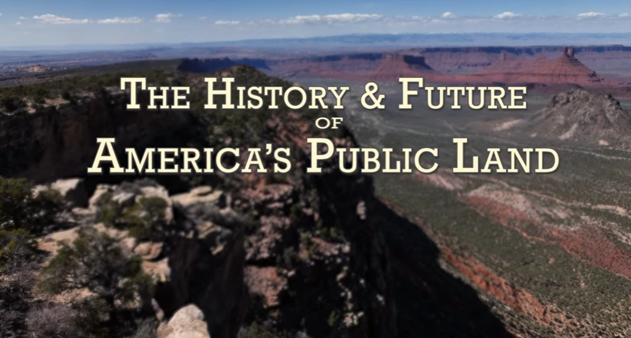
Walt Dabney, former National Park Service Superintendent and Texas State Park Director, discusses the history and future of America’s public lands. This presentation was filmed at a guide and outfitters training in Moab, Utah. CNHA has supported the parks and public lands of southeastern Utah since 1967. Sales from our retail outlets & online store, memberships and donations support the education and research efforts of our public land partners: The National Park Service, Bureau of Land Management and USDA Forest Service.
 The Camp Fire that started it all
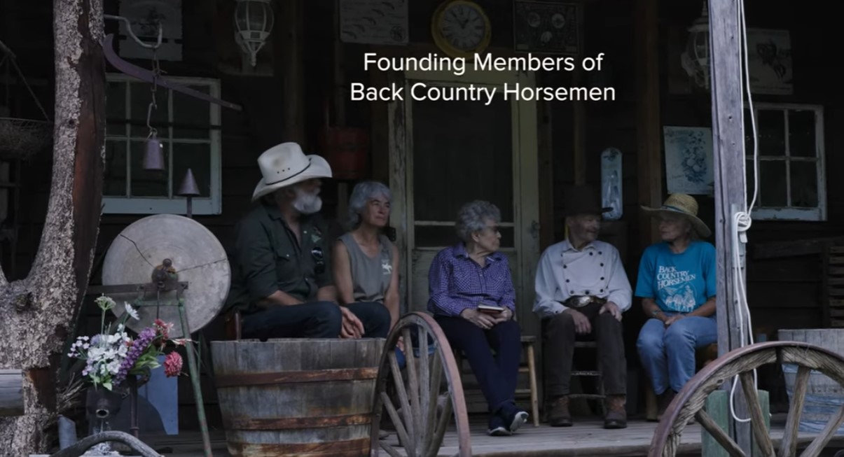
BCHA Founders

BCHA, Who we Are and How to Help

There is a lot of confusion about the chainsaw protection standards and how they vary around the world.
Type C, Class 1, chainsaw fabric layers, chainspeed, test methods ….
Understanding the global chainsaw protection standards is becoming increasingly important as arborists explore work opportunities in different countries and as arborist retailers start shipping outside their home country.
We thought that it was time to put a comprehensive guide to chainsaw protection standards together. Grab your popcorn and read on.
Broadly speaking, all of the current global standards for chainsaw protective legwear can be classified under two headings: European and North American.
The standards under either of these headings specify the general requirements for design and construction, the protective coverage areas, the performance testing needed, the certification process and the labelling and marking information required.
The Australian/New Zealand standard, AS/NZS 4453 and the Japanese standard JIS T 8125: 2022 are virtually direct copies of ISO 11393, so for the purposes of this paper these will be grouped under the European heading.
The Canadian standard, ASTM F3325, is very similar to ASTM F1897 so comes under the North American heading READ MORE
 Your chainsaw safety gear is important. Really important. Continuing cases of chainsaw injuries show that there is a real need to educate chainsaw operators on the correct selection and use of chainsaw safety gear.
This guide examines the different styles and options of chainsaw PPE available to the user and how to choose the best chainsaw protection for your unique situation.
There are two main types of chainsaw safety apparel, chainsaw trousers or chainsaw chaps. Both have the special fabric permanently sewn into the garment. Within each of these styles of garment there are variations designed to meet the differing needs encountered by those who use a chainsaw.
When deciding which style and which product is best suited for your needs there are a number of factors to consider:
1. How often you use the chainsaw
2. The type of work you are doing
3. The environment you are working in
4. The quality/durability you desire
5. The standards and/or regulations governing the work you are doing
6. You/your company’s budget and safety culture
If you are using a chainsaw frequently as part of your normal daily work, you should consider wearing chainsaw pants rather than chaps. In general, pants will be lighter overall than chaps worn over a pair of standard jeans. Chainsaw trousers will be more comfortable and there are no straps that can get snagged on branches or machinery.
Think about the time taken to put chaps on and off during a day, whereas with trousers you always have your chainsaw protection with you.
From a company’s perspective, if the staff are all wearing chainsaw trousers, you will have peace of mind knowing that good safety practices are being followed. With chaps, it is all too easy to avoid the hassle of putting them on just to perform a small cutting job.
Modern chainsaw trousers are made using technical fabrics and complex designs for a better fit and higher level of comfort. READ MORE
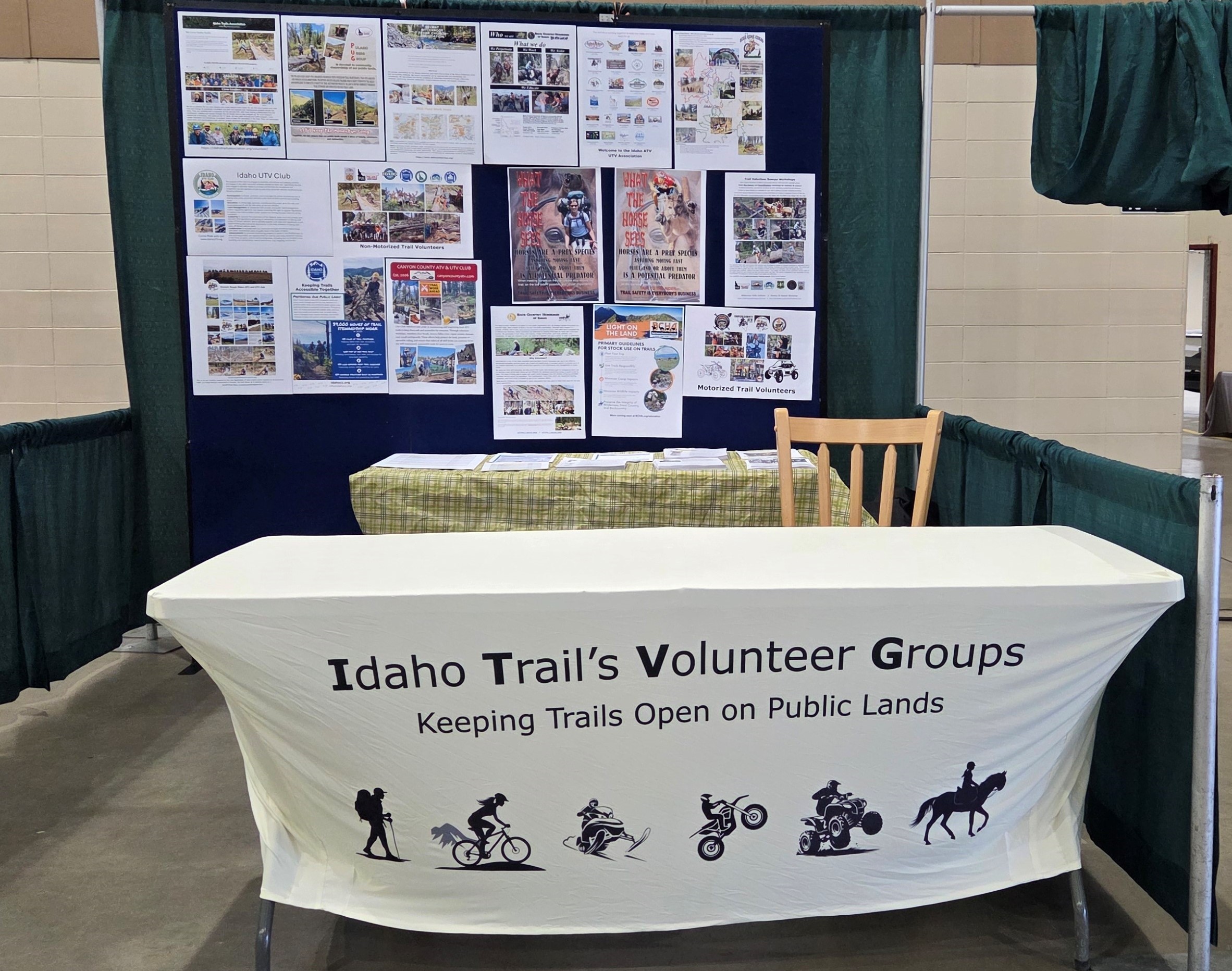
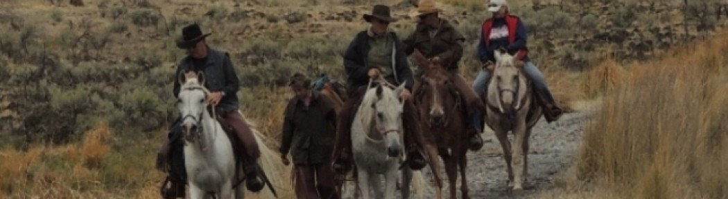
Back Country Horsemen of Idaho hosted a booth at the Idaho Sportsman Show March 5-6 that informed the public about all the various volunteer groups that do trail work on public lands as part of their charter. Members from BCHI, ITA, SBFC, TVTMA, Boise Ridge Riders, CC-ATV, Emmett Rough Riders and Idaho ATV manned the booth during the show and handed out information about both motorized and non-motorized group that might be of interest to the show attendee’s. They also told the public what their specific group does on public lands and how to get involved. The general feeling was the booth was very successful and these groups have committed to supporting a “Trails” booth in 2027/