Updated on 02/28/2024 BLM Owyhee Travel Management Update 02-28-2024
BLM Issues Decision for Silver City Travel Management Plan March 25, 2024
# * # * # * # * #
The 3rd of the five Owyhee Travel Management Plan (TMP) draft Environmental Assessments (EAs) is now open for public comment. Area covered is the Morley Nelson Birds of Prey National Conservation Area, South (or just NCA).
The first and second TMP processes resulted in “Alternative D+” Decisions: Canyonlands East; Canyonlands West. Silver City and Grand View areas are expected to enter the draft EA process and be completed by March 2024.
Comments will be accepted for NCA until January 8, 2024, through BLMs web portal (see “Participate now”) at the E-panning page for NCA South.
(Please do not submit comments to any BLM email address, they will tend to go into a black hole– use the Portal linked above.)
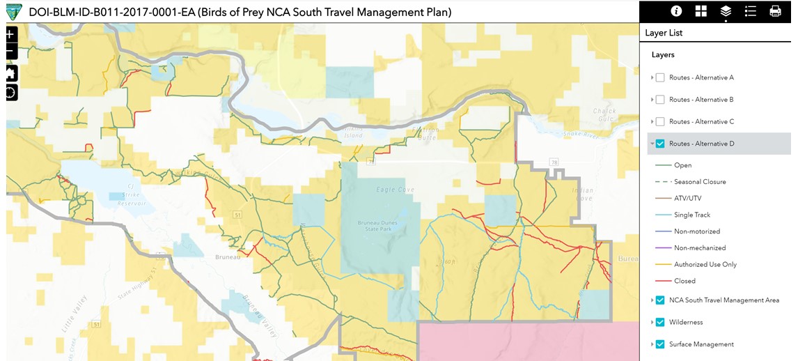
Using the BLM NCA South Alternatives map (see special instructions further down) and your knowledge of the ground, form your comments advocating for the most possible access (Alt D), siting route numbers and reasons to support keeping a route open such as looping opportunities. Alt A will not be selected; it is for showing “existing condition” based on the inventory BLM arrived at during previous process in 2016-7 and IDPR and stakeholder feedback. (Click on routes on the BLM map to get #s.)
Compared to IDPR’s current map for the area, access to several singletrack trails is proposed to be added under Alt D, fewer under Alt C. (Off-designated-route travel has been prohibited since passage of the 2009 OPLM Act.)
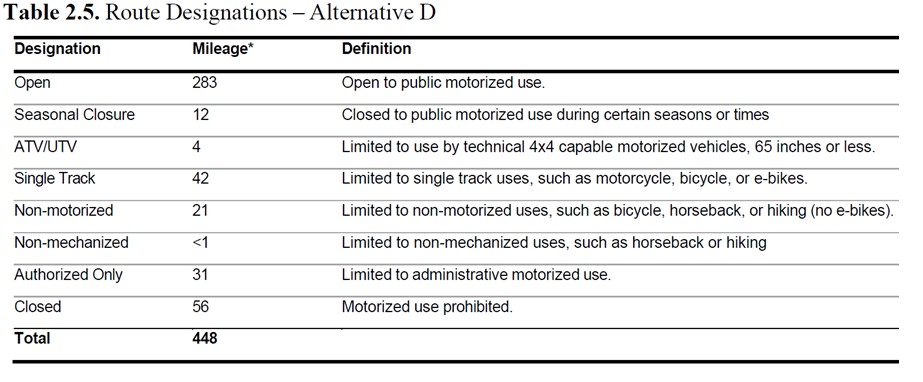
The NCA South Travel Plan covers approximately 112,087 acres of BLM-managed lands, the portion of the Birds of Prey NCA south of the Snake River. It analyzes 448 miles of routes inventoried by the BLM pursuant to the 2009 OPLM Act which requires travel management planning to be completed for all BLM ground in Owyhee County. The range of action Alternatives being considered (B, C, D) would designate between 154 miles (Alt B) to 341 miles (Alt D) of motorized routes for public use.
Access would include routes near or across Highway 78 from existing Rabbit Cr and Fossil Cr OHV trailheads, and other routes north of the Canyonlands East and West travel management areas.
Anyone interested in a GeoPDF map of NCA with Alternative D Routes added, please reply with that request. We will work to produce these if requested.
The most motorized access option, Alternative D, proposes the following route mileages per Draft EA page 17:
(Note “Open” = full-width, and there will be no 50″ or under designations.)
BLM NCA web map https://blm-egis.maps.arcgis.com/apps/webappviewer/index.html?id=255cd29a2da448a4b18639af92cbb029
Pull down the Layer List, UNCHECK “Routes – Alternative A” and check “Routes – Alternative D”. Expand by clicking the small arrow to see the Legend symbology colors.
Leaving “D” checked, you can toggle the boxes for “C” or “B” to show the differences between the Alternatives by route type and whether proposed to be Open or Closed.