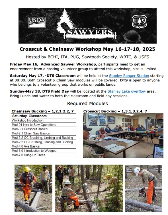
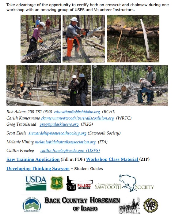
Forest Service News Release
Boise National Forest

Contact: Mike Williamson, Public Affairs Officer, 208-373-4105, michael.williamson@usda.gov

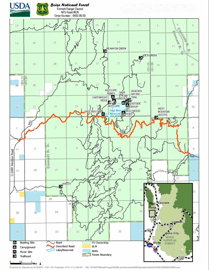
Forest Service’s Sage Hen Road Temporarily Closed for Repairs

BOISE, Idaho, May 30, 2024 – The Boise National Forest will temporarily close Road 626, also known as Sage Hen Road, beginning June 3 at 7 a.m. through June 7 at 6 p.m. to allow for construction crews to replace culverts and install road stabilization structures. The closure will begin at the intersection with Forest Road 644, located about 1.5 miles west of Smiths Ferry and extend 16 miles to the intersection with Forest Road 653 about nine miles north of Ola.

This closure is part of a larger road improvement effort that will extend into the fall and to other nearby National Forest System roads in 2025. While no other closures are expected this year, the public may experience temporary delays throughout the summer as crews complete road resurfacing and other improvements.

“We understand this closure will be an inconvenience to those visiting the Sage Hen Reservoir area,” says Boise National Forest Engineering Staff Officer Brett Barry. “By closing the road for five days and allowing the contractor to complete the needed work, we avoid having staged closures stretched out over several weeks.”

During this road closure the Sage Hen Reservoir area can be accessed via Forest Road 653 beginning 13 miles north of Ola at the Third Fork Guard Station, easterly to Forest Road 609, then southward to the reservoir.

For more information contact the Emmett Ranger District at 208-365-7000

2024-05-30 Sage Hen Road 626 News Release

Sage Hen Road 626 Closure Map

Sage Hen Road 626 Closure Order

30. May 2024 · Comments Off on Public Lands – Prohibited items have go into effect on all BLM Administered public lands · Categories: Public Lands

By Mindy Gould on Tuesday, May 28th, 2024
HARNEY COUNTY (Released by the Burns Interagency Fire Zone)-‘Tis the season! Effective last Friday, May 24, 2024, on all BLM-administered public lands in Oregon and Washington, the following are PROHIBITED:

Discharging or using fireworks or pyrotechnic devices. Discharging or using combustible or explosive composition or chemical devices, including but not limited to exploding targets. Discharging or using tracer, explosive, or incendiary ammunition. Discharging steel component (core or jacket) ammunition, except a person with a valid state hunting license actively engaged in the legal take/pursuit of Game/Non-Game species in accordance with the current hunting seasons. Releasing or causing to be released any sky lanterns, airborne paper lanterns, aerial luminaries and/or fire balloons. Shooting at any metallic object, including but not limited to using metal targets for target shooting.

Nearly 90% of wildfires are human-caused. Follow these restrictions and help keep our public lands and surrounding communities safe!

Those who violate the restrictions can be fined up to $1,000 and/or receive a prison term of up to one year. In addition, those found responsible for starting wildland fires on federal lands can be billed for the cost of fire suppression.

Local questions, contact your local dispatch center for more information.

25. May 2024 · Comments Off on Public Lands – Idaho Conservation League – Spring 2024 Updates · Categories: Current Events, Public Lands


The Latest News on Idaho’s Public Lands

Our work reviewing project proposals and permits—both exhaustive and sometimes exhausting—pays off in big ways.

The Idaho Board of Environmental Quality recently issued a decision invalidating Perpetua Resources’ air pollution permit for the proposed Stibnite Gold Mine. The Board found that Perpetua Resources and the Department of Environmental Quality (DEQ) failed to follow regulations designed to protect people from arsenic-laden dust. The decision remands Perpetua’s air pollution permit, sending it back to the administrative hearing officer to reconsider ways to better control arsenic emissions and reduce cancer risks from the proposed mine. 

In response to another protest by ICL and our partners, a Hearing Officer with the Idaho Department of Water Resources (IDWR) also established minimum stream flows to Perpetua’s water withdrawals that are more protective of fisheries. 

Finally, if you care about the four million-acre Nez Perce-Clearwater National Forest in north central Idaho, then you’ll be interested to learn about the status of the Forest Service’s efforts to revise the Land Management Plan.

ICL participated in a three-day administrative hearing to voice objections to the agency’s near-final new plan, arguing that it would harm wildlife, wildlands, and wild rivers by increasing off-road vehicle and snow machine access while shrinking the boundaries of the proposed Great Burn Wilderness Area. The Forest Service has also preliminarily stated that the North and South Fork Clearwater Rivers are not “suitable” for protection under the Wild and Scenic Rivers Act. It is unclear how the Forest Service will respond to the objections of ICL and other conservation groups, but a written response is due to be published sometime in June. Until then, stay tuned!


24. May 2024 · Comments Off on Public Lands – Travel Management in the East Fork South Fork (EFSF) Salmon River · Categories: Public Lands

Comment period is open until June 5 for the Draft Environmental Assessment (DEA) affecting the future of Travel Management in the East Fork South Fork (EFSF) Salmon River portion of the Krassel Ranger District, Payette National Forest.

Proposals in the Draft range from no-change in motorized access, to adding up to about 26 miles of public road and trail access beyond the current inventory.

The Forest will issue a final Decision Notice and implement the plan estimated October 2024. The Decision will guide how motorized access is managed to this portion of the Forest going forward. No losses are expected, but gains are possible depending on the Forest’s final Decision.

Learn more about the Draft plan here: https://www.fs.usda.gov/project/payette/?project=60889

Comment submission form here: https://cara.fs2c.usda.gov/Public//CommentInput?Project=60889

(Attaching a DOC or PDF of your comments is recommended; else, type or paste text into the form fields provided.)

The Forest presently manages motorized access in the EFSF area under the 2007 Payette Travel Management FEIS, the 2008 McCall/Krassel and 2010 Big Creek Yellow Pine TMP Records of Decision, and the 2024 Motor Vehicle Use Map.  A 2017 settlement to a lawsuit which challenged the 2007/2008/2010 TMPs requires this Plan to be completed. (Two of three Plans total required by the settlement were previously Decided and are in the process of being implemented: Big Creek and South Fork RAMPs.)

IDPR has submitted its commentary based on the themes summarized below. Additional requests are based on routes which stakeholders have for many years been asking the Forest to implement.

  •  IDPR Supports Alternative D, plus proposed modifications:
  •        Re-open Sugar Creek Road 51883 as a Trail for 70” and under OHVs (closed ~2016)
  •        Re-open Crater Lake Road as a Trail for 70” and under OHVs (closed ~2016)
  •        Re-open Parks Peak Trails 069 and 074 to 2-wheeled OHVs as-proposed in Alt D, and also re-open connecting Rainbow Ridge Trail 070 to create a loop (each closed ~2000)
  •        Give greater consideration for the economic survival of the Yellow Pine community, which recreation visitation will ensure

Please inform fellow recreationists of this public process.

22. May 2024 · Comments Off on Education – Dates for 5th Stanley Sawyer Workshop 2025 · Categories: Around The Campfire

Pictures from the 2024 Workshop

Stanley 2025 Workshop-DRAFT

22. May 2024 · Comments Off on Education – R1 Advanced Crosscut Saw & Axemanship – Train the Trainer · Categories: Education, Safety

21. May 2024 · Comments Off on Public Lands – May 2024 SCNF Partnerships Newsletter · Categories: Current Events, Public Lands

SCNF Partnerships Newsletter – May 2024

21. May 2024 · Comments Off on Education – Study on Ridge to Rivers (R2R) – Boise State University · Categories: Education, Public Lands


Participate in this study

Regenerative Recreation.PDF

16. May 2024 · Comments Off on Education – Sawyer – Lessons Learned – Chainsaw Operation Injury · Categories: Education, Safety


March 2024 Lessons Learned

16. May 2024 · Comments Off on Education – Sawyer link to the Accident /Near Miss Reporting Form · Categories: Education, Safety

10. May 2024 · Comments Off on Education – IWF – Idaho Legislative Voting record 2024 · Categories: Around The Campfire


2024+Legislative+Voting+Record

09. May 2024 · Comments Off on SCNF – Pre-Season Partner Meeting Notes · Categories: Public Lands, Public Meetings, Trail Volunteer Groups

Hi everyone,

A big thank you to those who were able to join us for Monday’s SCNF Pre-Season Partner meeting. I know it’s a busy time of year for this group. Attached are meeting notes, which have also been uploaded to the SCNF External Partner Folder in Box. A reminder, this folder also contains some general safety documents, Risk Assessments, our Grants Calendar, etc. If any of you have trouble with this link, let me know and I’ll make sure to get you access.

If you have any questions, go-backs, or other things you wanted to talk about that we didn’t get to, don’t hesitate to reach out. We hope each of your organizations has a safe and memorable season and look forward to connecting with some of you in the field this year!       SCNF PreSeason Partner Meeting Notes 5.6.2024

07. May 2024 · Comments Off on IDPR – Ashton-Tetonia Trail Paving Project – Comments · Categories: Around The Campfire


Link to Comment Page

06. May 2024 · Comments Off on Idaho – Craters of the Moon National Monument · Categories: Around The Campfire

Descending into the ancient volcano feels like being swallowed by a monster. I set up camp in the mouth of the beast, surrounded by 200-foot cliffs—and am immediately overwhelmed with peace and quiet. But the tranquility in the crater bottom belies a violent past: Two-thousand years ago, molten rock gushed from these cracks in the earth, while ferocious explosions from thousand-foot-high cinder cones sent car-size boulders hurtling through the air. A quick foray from my campsite, 3.8 miles deep in Craters of the Moon National Monument, reveals evidence of this rocky past. Cylindrical cavities mark the spots where trees were entombed in flowing lava before rotting away, leaving their hollow forms in the hardened rock. Jagged chasms exist where ancient tunnels of lava formed and collapsed. A weekend of exploring these geologic wonders only fuels my curiosity—and ensures that I’ll be back soon.  Link to story

Anna Daly writes: Craters of the Moon National Monument hit a big milestone this month – turning 100 years old.
On May 2nd, 1924, the more than 1,100 square mile area of volcanic formations and lava fields in Central Idaho’s Snake River Plain was designated a national monument by President Calvin Coolidge.