As of April 28, the Grandview Travel Management Plan process has been STOPPED and will be reset, starting the process over sometime in the future!

All, Please see the final version of the Doyle Mountain Trail Proposal attached.

If you would like to support this proposal (or some version thereof) just mention your support for the “Doyle Mountain Trail System” from ICL and company in your own individual comments (due Monday).

Here is a link to the Grand View Travel Management Plan on the BLM ePlanning website:  https://eplanning.blm.gov/eplanning-ui/project/73197

To make submitting comments easier, here is a link to ICL’s take action:  https://takeaction.idahoconservation.org/fmCRkTb

Thanks, all, and have a great weekend.

John Robison / Public Lands Director / Idaho Conservation League
PO Box 844, Boise, ID 83701
Mobile phone 208-345-6933 x 213 • fax 208.344.0344

http://www.idahoconservation.org

Doyle Mountain Trail System proposal final

29. March 2024 · Comments Off on Education (Sawyer) Riggins man dies after tree falls on him in Idaho County · Categories: Around The Campfire

Riggins man dies after tree falls on him in Idaho County

Local authorities responded to a call of an unconscious man being transported to Riggins, where he later died.
Author: KTVB Staff
Updated: 12:24 PM MDT March 26, 2024

RIGGINS, Idaho — Just before 1 a.m. on March 20, Idaho County Dispatch received a call regarding a 28-year-old man who was hit by a tree while cutting firewood, according to a news release from Idaho County Sheriff’s Office.

The call they received informed dispatch that there was an unconscious man with a pulse being driven to Riggins.

The man, Tyrel Walker, of Riggins, was up on the Big Salmon in the Allison Creek area when the incident happened, and was transported to Riggins to meet the ambulance. The ambulance met the man and his colleagues on Main Street in Riggins, and Life Flight was dispatched, while Riggins Ambulance performed life saving measures.

At roughly 1:11 a.m. Riggins Ambulance informed dispatch that life saving measures would be stopped, and Life Flight was canceled.

Idaho County Deputies and Idaho County Coroner responded, and investigated the situation later that day. The incident happened six miles up French Creek Road. It appeared to investigators that Walker had chopped down a tree, then was hit by another tree, striking him in the head.

Officials say Walker’s injuries were consistent with that of someone being hit by a tree.

26. March 2024 · Comments Off on MedWild – Wilderness Medicine, Survival, Rescue Video Library · Categories: Education

GO TO VIDEO LIBRARY

26. March 2024 · Comments Off on How to use a SAM Splint (Forearm) | Wilderness Medicine · Categories: Education

WATCH VIDEO


58,209 views May 14, 2013

Dr. Donner discusses some key general tips for SAM splint use, and demonstrates a sugar tong splint for wrist and forearm injuries. Includes discussion on structural bends, fitting and molding technique, immobilization with sling, supination, and pronation. MedWild provides wilderness medicine, wilderness survival, and search and rescue instructional videos on a variety of topics: high altitude illness, traveler’s diarrhea, shoulder dislocation and reduction, shelter building, bushcraft, space blankets, hypothermia, medical kits, survival kits, frostbite, snake bites, fire craft, ropes and knots, orthopedic injuries and sam splints, cold water immersion and more.

Instructor: Howard Donner, MD Co-Author “Field Guide to Wilderness Medicine” Served as a physician for Denali National Park, Himalayan Rescue Association, and the 1998 NOVA Everest expedition. Served as a medical operations consultant for NASA for over 5 years. Whitewater rafting guide, commercial pilot, and certified flight instructor.

Recommended Audience: Outdoor enthusiasts and health care professionals including physicians, nurses, search and rescue teams, EMT, paramedics, ski patrol, corpsman, guides, instructors, wilderness first responders, and anyone else interested in educational and “how to” videos on wilderness emergency medicine, search and rescue, expedition medicine, backcountry first aid, wilderness survival training, and military medicine. Dr. Donner’s draws on his extensive backcountry and travel experience to highlight key signs, symptoms, treatments, and improvised techniques and skills.

More from MedWild: Complete Video Library:    / medwildvideos     / medwildvideos     / medwildvideos   MedWild videos featured at: www.wilderness-medicine.com

26. March 2024 · Comments Off on BCHI – Important Chapter Due Dates · Categories: BCHI /BCHA

READ Full List:  Due Dates for Chapters

19. March 2024 · Comments Off on BCHI Saw Coordinators – Region 1 & Region 4 · Categories: BCHI /BCHA

Region #1 – North of the Salmon River

Region #4 – South of the Salmon River


18. March 2024 · Comments Off on Pack Saddle – Chain Saw Carrier · Categories: Around The Campfire, Education


Single Saw carrier for mounting on top of a decker pack saddle

18. March 2024 · Comments Off on “Shoshin” or “Beginner’s Mind” in Zen · Categories: Education

Be a “Professional Beginner

Always be learning, always striving to approach the process with the wide openness of someone starting fresh and fighting the natural tendencies to Narrow one’s mind and calcify one’s conceptual model.

New Information should be welcomed despite its demands for flexibility and ongoing adaptation.  With this approach, learning is also exhilarating, a journey of endless discovery and self-Improvement!

14. March 2024 · Comments Off on BCHA – March News Letter Highlights · Categories: Around The Campfire

Link  to  StudySurvey Link
Listen

12. March 2024 · Comments Off on Chapter – 2023 End of year report. · Categories: BCHI /BCHA

READ Complete report: 2023 YEAR IN REVIEW

08. March 2024 · Comments Off on 2024 BCHI – Convention Info · Categories: BCHI /BCHA


2024 BCHI Convention Itinerary

Photos of the Convention

07. March 2024 · Comments Off on BLM – Grand View Travel Management Plan · Categories: Public Lands, Public Meetings

x

LINK TO TRAVEL PLAN DOCUMENTS

07. March 2024 · Comments Off on SCNF – Spring News Letter, March 2024 · Categories: Around The Campfire, Education

SCNF Partnerships Newsletter – Mar2024

02. March 2024 · Comments Off on 2023 Garmin inReach® SOS Year in Review · Categories: Around The Campfire, Education

2023 Garmin inReach® SOS Year in Review

From hikers on daytrips to drivers on road trips, the inReach SOS data from 2023 shows that inReach devices are an important tool for adventurers and commuters alike. In 2023 the largest percentage of SOS incidents came from hikers and backpackers, but the biggest increase resulted from driving-related situations. Read on for a look at the statistical breakdown.

Since 2011, Garmin inReach satellite technology1 has helped individuals stay in touch globally, send and receive messages outside of cellphone service areas, navigate routes, track and share journeys and, when necessary, trigger an interactive SOS message to the Garmin Response℠ emergency response coordination center. Many individuals’ lives have been changed from the help they received after triggering an SOS message on their inReach device.

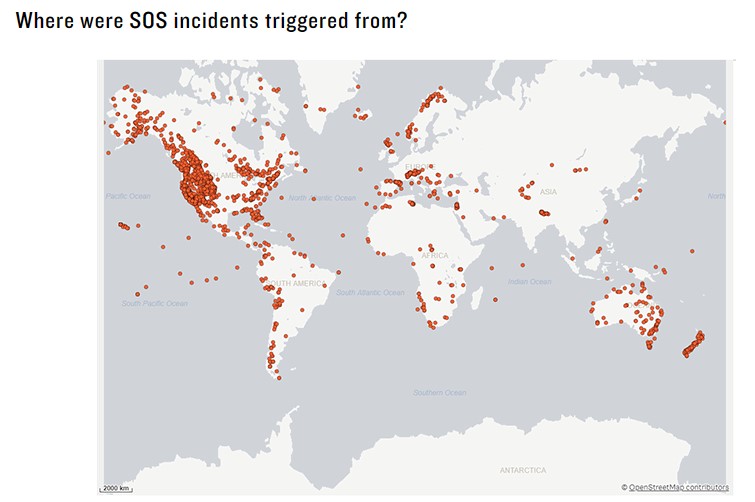
With 100% global Iridium® satellite network coverage, an SOS can be triggered globally. The locations of SOS incidents speak to the power of the Iridium satellite network, the intel of inReach technology and the Garmin Response team’s ability to make timely connections with emergency resources all over the world.

Garmin Response is a leader in 24/7 emergency monitoring and incident response coordination services. Using a proprietary emergency monitoring platform that connects to a global database of first responders and emergency services, the dedicated team of skilled emergency response coordinators serves more than 200 countries and territories and supports more than 210 languages.

Just this year, dispatch responses varied from local police and ambulance services on major interstate highways to highly technical helicopter rescues on the world’s tallest mountain, Mount Everest. Responses all over the world — from New Zealand to Norway to Argentina to Canada — were coordinated for plane crashes, grizzly bear encounters, sinking sailboats, skiers in avalanches, stranded divers, injured climbers and many more.

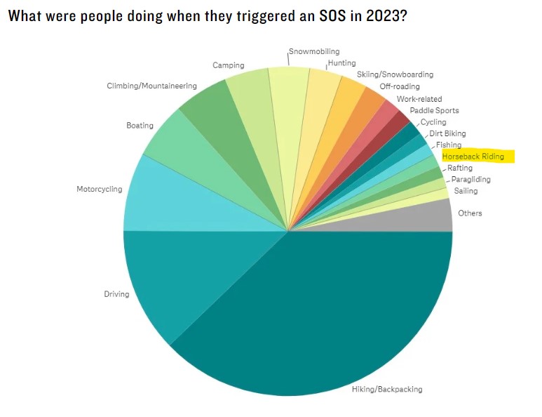
The largest percentage of SOS triggers this year came from adventurers who were out hiking or backpacking. The next highest number of SOS triggers came from driving and motorcycling incidents. This emphasizes the importance of having an inReach on hand for everyday “just in case” situations, such as witnessing or being involved in a motor vehicle accident, experiencing mechanical issues outside of cellphone service or encountering adverse weather while driving.

In 2023, we saw the biggest increases in driving-related SOS incidents, followed by climbing/mountaineering and fishing. Other common activities include boating, snowmobiling, camping, hunting, skiing/snowboarding, off-roading and more.   READ MORE


What’s Different About inReach Technology?

Staying connected, informed and safe — regardless of geographical location — has become an essential and expected part of our lives. So what makes inReach® satellite communicators stand out? Below are some of the top reasons why it’s advantageous to keep a device with inReach technology active and available1.

Connection to the Only Satellite Network with Global Coverage

The Iridium® satellite network, the world’s largest commercial satellite constellation, is the system that allows inReach devices to work globally. Its low orbit satellites enable inReach satellite communicators to relay messages, provide weather forecasts, navigate and trigger SOS alerts — even when you and your device are well out of range of cellular coverage. Plus, the multidirectional, purpose-built antennas in inReach devices help ensure a prompt connection, which is especially important in an emergency when every second counts.

Interactive SOS

With an inReach device and an active subscription, you can trigger an SOS message and connect directly to the Garmin ResponseSM team. When an SOS alert is received, team members pinpoint the incident location. Then, via two-way messaging, team members gather information from the user, coordinate the rescue response and connect with emergency contacts.

Internal Emergency Monitoring

A unique part of the inReach experience is that SOS activations are managed by Garmin’s in-house emergency monitoring team and incident response coordination center, Garmin Response. Operating since 2007, Garmin Response is staffed by trained professionals. They use proprietary emergency handling software to manage each SOS alert and work with a private global database of local first responders. The Garmin Response team has handled more than 10,000 inReach SOS alerts.       

READ MORE