Cascade Ranger District – Proposed action Report (pdf)
See page one for instructions on how to comment on this proposed action report.
Cascade Ranger District – Proposed action Report (pdf)
See page one for instructions on how to comment on this proposed action report.
We had a great turn out for the Hitt Mountain Tool Cache project. Ten members and one guest worked on two trails. Eleven head of riding stock and eight head of pack stock were brought to support the project. The riders on the 268 trail reported it was an enjoyable ride, with great views, ending close to the Sturgill Peak Lookout.
The 270 trail was difficult at first to find due to numerous cow paths and healed over tree blazes, but was successfully found after some scouting around. There were quite a few down trees, and a lot of brushing done. Approximately 2.5 miles of the trail was cleaned.
As usual, we had delicious group meals and lots of good conversation. We have some fantastic camp cooks in our group.
If your interested in a nice ride up West mountain with interesting trails and nice views I can recommend that you make a loop ride out of the Wilson Corral trail [TR135] and the Gabes Peak trail [TR136]. Truck / Trailer parking can be either at the Wilson Corral trail head or Rammage Meadows camp ground where the Gabes Peak trail head is located. I recommend you ride up [TR135] and down [TR136] but either way works nicely. The Gabes Peak trail has some climbs that make it slow going up.
Wilson Corral trail follows a creek in tall timber for the first couple of miles and then crosses a string of meadows ending up north west of the Radar Dome on Snow Bank mountain. In the meadows the trail gets quite indistinct, as cattle summers graze this area. You will see trees marked, and rock carrions. Continue up the meadows until you can not go any higher without dropping down into a small valley, around 7400 feet.
Look to your right and you will see a small meadow down through the trees and a rocky hillside between you and the radar dome. The trail heads down the hill through the trees into the north end of this meadow. You really dont want to cross the rocky slope as the going is dangerous on very loose rocks. A nice place to give your horses a drink is located in this meadow.
From here the trail heads south and is easy to follow. You continue south along this grassy valley until you come to a line shack. At this shack, the Gabe’s Peak trail branches off to the right. The trail go left of some large rocks and works its way along a south facing slope into a series of meadows along a ridge. Stay in these meadows and on the crest of the ridge and you will have little trouble following the trail. The trail leaves this ridge on the north side and works its way through some large timber coming out on an old logging road. Follow this road to Rammage Meadows. Robbin, his grandson Al, and I rode this loop trail easily on a Saturday leaving the trail head around 10:00 and being back at camp in time for cocktails. This assumes that trail maintenance has been performed prior to making this ride, else it will take a bit longer.
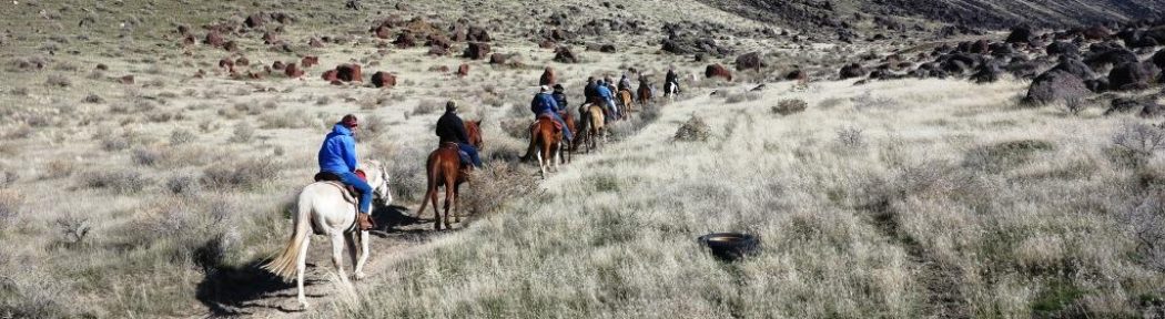
The Lightning Ridge trail is a 13.5 mile ride between Deadwood Reservoir and Forest Service road NF-611 (Lightning ridge road) in Garden valley. Linda Hays and I rode some of this trail from the west, Garden Valley end. The one lane road to the trail head is in very good shape, and the parking for trailers is limited, so this is not a good chapter ride. But for small groups, of not more then maybe 4 trailers this trail offers one of Idaho’s best ridge rides. This is not a ride for people or horses that don’t like to climb and are not comfortable riding on a hill side, as this trail has both. It also has some wonderful granite rock formations and great views of Scott Mountain, Onion Valley, Garden Valley and the surrounding mountains. During our ride the wild flowers were doing their best to cover the hillsides. The west end of this trail is dry, not crossing any streams and the section we rode did not have a lot of shade. On our trail scale of 1 to 5 with one being a flat dirt road and 5 being OMG, this is a 3.5
Squaw Butte BCH 4th of July Pack Trip
During the three day weekend of July 4th Squaw Butte BCHI will be hosting a beginner level pack trip for members and their families. This is the perfect opportunity to experience a backcountry trip and to put into practice some of the skills you were introduced to at the Backcountry Skills Clinic in March. The trip is to the Corduroy Meadows area of the Frank Church Wilderness. This is an easy trailhead to drive to, and a very easy area to pack into. The plan is to pack into a base camp that is an easy 90 minute ride from the trail head. From this base camp there are a number of day rides to explore this beautiful country. Our trailhead is the North Fork of Elk Creek [34] and we will ride north on trail [005]. Our base camp is located in the UR area of Corduroy just south of Porter Creek and west of Elk Creek. This is an easy ride of just over three miles. Our chosen camping area has a good location for stock and a separate area for tents and the kitchen. There is good access to water and grass for the stock. If this area is taken, there are a number of other spots in the area that will work also.
Planned Schedule:
Friday: July 4th
Travel to trail head, pack-in and set up camp. We will be riding and packing in twice once at 10 AM and again at 1 PM. Opportunities to day ride and start exploring area. Tasty Dutch oven dinner. Quality time around the camp fire to get to know each other better.
Saturday: July 5th
Hardy Breakfast, day ride to Bernard Lake. This will be the only opportunity to fish, as fishing is not allowed in either Porter or Elk Creeks. Bernard is a beautiful mountain lake and a great place to enjoy lunch. Delicious Dutch oven Dinner, more quality time around the camp fire.
Sunday: July 6th
Rib sticking breakfast, break camp, opportunity to take a morning ride, pack-out, return to our homes.
Who should come on this trip?
Anyone who is interested in learning minimum impact backcountry camping techniques and would love to safely explore a unique section of Idahos backcountry. If you have pack stock and would like to improve your skills, or like a little mentoring, this is the perfect trip. If you dont have pack stock, thats ok, our members with pack stock will make sure your duffel makes it from the trail head to the base camp and back to the trail head at the end of the trip. This is a hands-on trip with everyone expected to lend a hand. If you want a catered trip, contact an outfitter. It is highly recommended that members who plan on going on this trip take time to watch the Horse Sense DVD that was part of the package at the clinic. If you didnt get a copy, and would like one,
contact Rob Adams.
Requirements:
You need to bring your own riding horse, and personal gear. A suggested list will be available on the website in .PDF format. If you do not have pack stock, your duffel, with personal items, and sleeping gear has a 30 pound limit. You will need to bring your own lunches. Bear safe storage will be available for your lunches, snacks, and toiletries when in camp. Friday dinner, Saturday breakfast and dinner and Sunday breakfast are group and will be provided. A small fee to help cover the cost of the food will be collected with your trip registration. When youre packing, think light weight, but also variable weather conditions. Nothing ruins a trip faster than being wet and cold.
To help us plan for this trip, to make sure we have enough stock, food and marshmallows everyone who is going must fill out a trip registration form and have it and your check payable to SBBCH – for food mailed to Squaw Butte BCH, 2790 E. Black Canyon Hwy, Emmett, ID 83617 by June 22nd. Questions about this trip can be emailed to Projects@sbbchidaho.org
I meet Sally and Robbin Schindele on a 4th of July pack trip that Squaw Butte was hosting in Elk Meadows of the Frank Church Wilderness. I noticed the man on the big paint horse and a woman with a big smile on a flashy mule while packing the members in. I didn’t get a chance to talk to them during the day but around the campfire found out they were from the mid-west, into sailboats and had lately moved to Idaho to start a new adventure. A history very similar to Linda’s and mine. Since that first meeting we have shared a lot of camp fires and trails together. In the years I have known Sally; we have ridden a lot of great trails, eaten some excellent meals, and skied many runs. I never heard her complain, to not step forward when something needed to be done, or not have a smile or a welcoming word. After a long hard day on the trail, she was the first to step forward wanting to help get dinner ready, or to get the cool drinks and snacks out. While Sally was not a strong rider, she was a very game one, willing to follow someone she trusted on trails that contained some real “Kodak Moments”. During Sally membership in Squaw Butte, she held a number of positions of responsibility, both elected and on committees, if she said she would do a job, it was done, and done well. I will miss my friend, her smile, her wit and her enthusiasm for the mountains and the back country.
To: “Chris Robbins” <christopher_robbins@blm.gov>
Subject : Urban Legend or Real?
Chris, I have been getting a lot of questions regarding people abandoning their horses to run with BLM horses. Is there any truth to this or is it just a rumor? If there is any basis to it these horses may not survive. The band stallion may take in some mares but surely would not allow a gelding in. They also would not be able to find food/water in the summer months since they would have no experienced herd leader to follow. Not to mention domestic horse don’t have hooves as tough as Mustangs and would stone bruise easily. You know all this already, don’t know why I had to go on about it. Just thinking how stupid that would be to do that. Any truth to it? I’m hoping not. It’s too expensive to gather the ones as is.
Joanna
Sunday May 4th
We rode the lower 5 miles of the trail today.The trail has a good surface, gravel, but is probably soft enough for non-shod with tough feet. There is a few narrow openings for people and horses to get around locked gates. 2 miles in there is a wooden bridge to cross over a cattle access to the river. A dead beaver (still pretty ripe) and a deer carcass (not ripe), lots of rock chucks, geese, goslings, ducks (no ducklings), lizards, and birds. Only snake we saw was taken directly over us by a hawk. Good thing he didn’t drop it, it would not have been a good deal. We turned around at a gate that was closed but not locked so can go through it.
Think parking will be limited if we park by the dam, maybe 6 or 7 rigs with trailers. We made arrangements with Dillon to park in the field across the road from the dam, the company he works for owns the ground on both sides of the road. There are heifers in the field so will have to be careful about the gate, but there is lots of room.
The directions on the web site say to turn right at Unity lane, but people need to continue going straight on Weiser river road, over a small bridge over the canal to get to Galloway dam.
It was a very enjoyable ride, along the river all the way.
This project will be a nice ride to the work site and back with the project work itself boots on the ground. We in concert with the Emmett ranger district and some other volunteer’s are going to re-route a section of this trail from off a very steep ridge into a series of switch backs. The problem with the current trail is erosion and currently installed water bars just made the problem worse. Plan on a few hours with shovel and pick. We will have pack horses to carry the tools, but you should bring your favorite shovel. We will be setting up high lines at the work site for the stock while we work. Directions to Peace Creek Trailhead
This project is to open four trails in the Johnson Creek and Riordan Lake areas. Assuming we have enough members to have four crews, each with a chain saws and other required equipment. All trails were impacted by last years fires, and may have their access limited by late snow and or mud. Wapiti Meadows Ranch will be providing tent camping / camper space, and areas to set up high lines or portable corrals and access to stock water. The chapter will be providing weed free hay for the weekend. Wapiti Meadows Ranch will be providing Saturday and Sunday breakfast and Saturdays dinner. Friday dinner is a chapter provided BBQ, members will provide their own lunches. To attend a “Wapiti Meadows Trip Registration Form” must be filled out and sent in no later then June 5th, 2008 This is going to be a great trip, don’t miss it! Directions to Wapati Meadows South Fork / Johnson Creek Area Map / Wapiti Meadows trip Registration / Directions to Wapati Meadows via Landmark
I am planning on driving up to Big Willow Creek to camp on Friday night, camping Friday & Saturday, doing the Saturday ride in the wild horse area, and the Sunday ride at Sheep creek. This is a very flexible trip due to it’s short distance from Emmett. Members can camp and ride, or just day ride. Members who choose to day ride on Saturday, should also plan on sharing the pot luck dinner, before heading back to the homestead. Rides on both Saturday and Sunday will start at 10:00
Information: http://www.sbbchidaho.org/pdf/0805MemorialWeekendHorseCampingTrip.pdf
Directions to Big Willow Creek: http://www.sbbchidaho.org/Directions_to_the_4_Mile_Horse_Management_Area.pdf
Directions to Sheep Creek: http://www.sbbchidaho.org/Directions_to_sheep_creek_camping.pdf
Our Saturday April 26th ride to the Wilson Creek / Hard Trigger area was one of the better I have been on in this area. The canyon that trail [w100] passes through and water crossings were a perfect spring tuneup. Great weather also. Last year the BLM did a major improvement of the parking area at Wilson Creek, including installing bathrooms, this is now first rate facility. They also added a number of trail signs so it is much easier to navigate the array of great trails in the area.
This year’s clinic went very well, but it can always be better. Please talk a few minutes and think about your experience at the clinic. Please think about each presentation you attended. Were they in the best order? If you had been scheduling the day how would you have done it? Were they the right length [time]. Most were around 30 minutes, was that enough time?
What presentations would you like to see that were not done this year?
Was there enough information on packing and back country travel and camping?
Did you feel the hands on mentoring worked, or would more structured demonstrations and maybe classes have been better?
Handouts: Have you had a chance to view the DVD? Did you feel it has value? Have you had a change to look at any of the material on the CD? Do you feel that this is a good way to provide material, or would you have preferred a notebook full of printed material?
Should we continue to have featured presenters like Dr. David Hayes? Did his “One Step Horsemanship” fit into the rest of the clinic structure, or would it have been better in a different venue?
Packing Equipment (what we take) (Bill & Marybeth)
Idaho Brand Inspector (Larry Hayhurst)
First Responders (Sally & Tammy
One Step Horsemanship (Dr. David Hayes)
Lunch (quality & quantity) (Lunch Team)
Saddles & Equipment (Mike Becker)
Trailer Safety (Mike Quality Trailer)
Trail first Aid – Stock (Joanne, Bob & Erika)
BLM Wild Horse Program (BLM)
Opportunities in Boise NF (Emmett Rangers)
Dutch oven cooking (Ralph & Trudy)
Meal Planning – Trail head & Back Country (Marybeth)
Packing Demo’s and Mentoring (Packing Team)
Robert ‘Bob’ Dale Howard – President, Squaw Butte BCH – 2006
Pictures of Bob
Bob passed away in December 2007 after an illness. Bob was born in Stites, Idaho in 1928. Bob was an outfitter and guide for several decades and retired from the Idaho Highway Department. He adored his children and the outdoors, his horses and mules, hunting and riding in the wilderness. Bob was a member of Masonic Kooskia Lodge Number 87 and Past Master. Bob was President of the Boise Angus Club and was on the board for several years. He was also President of Squaw Butte Back Country Horsemen in 2006.
******
I Remember Bob
Ellen Knapp, president, SBBCH 2007, 2008
I remember Bob as a big, burley imposing, deep voiced man;
With a HUGE, gentle, generous and giving heart;
With a warm and welcoming smile;
With a wonderful sense of humor.
I remember Bob with tremendous knowledge regarding horses and packing;
With tremendous experience regarding horses and packing;
With a great willingness to share that knowledge unconditionally;
With a great willingness to share without judgment;
With a great willingness to share with us novices;
Patiently.
I remember Bob with an un flitching seat on his horse;
And great confidence in his horse;
Despite the trail crumbling out from under him.
He continues to gives me confidence in my riding.
I remember Bob as a very fair man
He never spoke ill of anyone.
I remember Bob as a wonderful Dutch oven cook;
He fed us fabulous delights.
I remember Bob teaching me
to back splice our ropes
and critiquing, encouragingly, my novice efforts.
I remember Bob teaching me,
patiently,
to mantee a load with elegance and minimal effort;
many times, each time with equal patience.
I remember Bob,
I will never forget Bob,
Bob lives on in me,
for he imbued in me his knowledge,
and made me a better person for my knowing him.
I remember Bob
And I will miss him greatly.