The Jump Creek 10

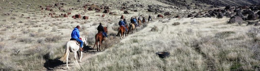
It turned out to be a beautiful day for the chapter’s fun ride in Owyhee’s Jump Creek Canyon.  Ten members of the Back Country Horseman of Idaho met at the trailhead ready to ride by 11:00 AM.

  My old, brittle pair of roping reins I won at an auction had finally given up the ghost and broke in two. Roger lent me a nice pair of marine-rope reins he had made and offered to repair my old set. I declined the repair offer – the reins were not worth fixing.

 Janine noticed I had acquired a rather annoying cough. Concerned for my health, she poured me a shot …I mean a measure of spirits she concocted; strictly for medicinal purposes, of course. Who am I to question?  Janine, after-all, is a medical professional! For fear my “cough” could be contracted by others in the group –Janine passed the bottle amongst those concerned for their health as well.

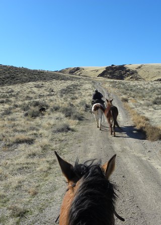
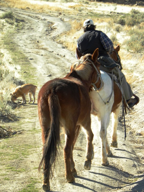
 Rob brought rides for Heather and Caius. Heather rode Willow and Caius rode Kestrel, a tough little mustang that could almost walk out from under Caius’s long legs. Rob rode his colt, Payette. Rob was NOT wearing his bright, lime-green jacket this trip. I sort of missed staring at the back of that eye-popping jacket. Roger rode a nicely put together bay gelding. Janine rode her big paint Two-Ton. The Chicks, Lorraine and Chuck, each rode flea-bitten Arabian’s. I rode my quarter-horse buckskin colt, Jack, and towed Annie, my mule. Shade followed along chasing ground squirrels and jack-rabbits.

Group

As such, the group of 10 riders, 9 horses and 2 mules set out for a fun ride in the sun and sand. Janine and I had scouted the area a couple weekends before. Without a definite destination in mind, we turned south west on an old ATV trail we thought might lead to Sands Basin. The road traverses up and down fairly steep, rolling hills – leveling out on large, flat plains overlooking scenic rock formations, sage and sand.

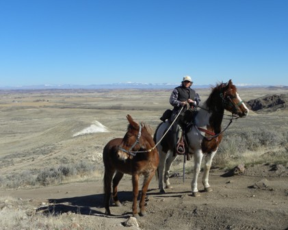
  A little past mid-day, the group broke for lunch atop a ridge overlooking Jump Creek Canyon. You could scarcely make out a strip of creek winding through a narrow section of the canyon below. The four legged’s also took advantage of the well earned rest and grazed contently alongside their two legged counterparts.

Lunch

  After lunch, riders took to the trail on rested mounts. We met up with a couple of hikers who were also enjoying a day in the sun. The hikers pointed to their truck perched atop a high bluff overlooking the canyon, a half mile away. The road leading to the truck dead-ended for motor traffic, but Janine and I knew from our previous visit that a foot trail veered off to the left and led back to our trailers. We opted not to continue on the road believed to be the route to Sands Basin. This was the first real ride for many of the horses since last fall and we did not want to over-stress them.

  Along the way, we picked up what little trash was found on the ride back to the trailers. I have an unwritten rule I have lived by since I was old enough to venture into the wilds alone, this I learned from my dad: “Always leave the area cleaner than you found it.” This usually means packing out more trash than I carry in.

  ChickBack at the trailers, Janine discovered a broken taillight on her trailer. Chick, aka Mr. Boy Scout – carry everything but the kitchen sink in his front pockets, just happened to have a spare tail light that fit. He assured us he carried the spare part in his tack room- not in his front pocket.

I reluctantly returned the borrowed reins with promise that Roger would make me a set. The group quickly un-tacked and funneled their way out of the large, graveled Jump Creek parking lot toward home. That is, all except Janine and I. Our weekend adventure was just getting started.

 As I bade farewell to the others, I could not help reflect on the day and notice how not one person let out so much as a single cough the entire ride.

The Celebration Park fun ride was cancelled over the weekend due to pending storms and high winds. Janine, being retired from the US Postal service, was not about to let a little rain, nor sleet, nor gloom of ominous winds stop her.  As for me, well, I guess I’m just stubborn. I’ve been called the “Hell or high water girl.” Once my mind is set on something, I’m going to do it come hell or high water. Janine and I loaded our animals, campers and a healthy dose of stubbornness, and headed to Jump Creek to try and get a ride in before the storm hit.

The plan was to meet at Jump Creek at noon on Friday. We would check out the area for the upcoming fun ride in March. Later, we would head for Celebration Park and camp for the night. If the weatherman happened to be wrong, we would ride Celebration Park on Saturday. Ride or not, it would give us both a chance to get the wrinkles ironed out of our campers before the upcoming projects season.

We parked in the large graveled area next to the trailhead designated for horseback riding. We chose a trail that looked like it might wind around toward scenic Jump Creek Falls. The trail was faint and almost non-existent in many spots, in others, it disappeared altogether. At times, neither Janine nor I could tell if we were actually on a trail. We opted to follow along a creek bottom that wound its way up a narrow gorge. The further we rode the more convinced we became that this might not be the best route for our group’s fun ride in March.  We turned around in search of a different route. We chose an ATV/jeep road that starts at the bottom of the sage covered hills just west from where we parked. The route looked more rider- friendly. Pointing our horses due west – we set out to explore this new course.

The road follows the lay of rolling hills that peak out at scenic vista’s and overlooks of ornate rock formations. The road splits off in several different directions. We split off left in hopes the trail would lead toward Jump Creek Falls. The route we took did indeed intersect a hiking trail that looped back to the falls. One particular spot in the trail did not look entirely kosher for horse traffic. We weren’t even sure if horses were allowed on this part of the trail. Deciding against the risk, we cut down the side of the mountain to avoid breaking any park rules or equine ankles.

Janine waited at the bottom while I continued to descend. Three-fourths of the way down my saddle had slipped enough forward that I was sitting entirely on my horse’s neck. I slid off and led the rest of the way down. Mental note to self: invest in crupper.

 We rode the horses to water at a spot accessible from within the camping area. On the way out, we noticed we were being filmed. The gentleman filmographer was quite taken by Janine’s paint horse, One Shot. I believe he was also quite taken by Janine as he made several efforts at small talk directed toward her as we made our way back to the trailers. As we began to un-tack, Janine’s personal paparazzi made his way over in a large, extended cab diesel.

 It turns out the retired DEA agent is an avid Everytrail.com subscriber and was putting together a U-tube film for the site. Whether it was Janine’s paint horse, or Janine herself that caught his eye – he did provide invaluable input into the surrounding area for our fun ride in March. Had we continued straight instead of forking off to the left, we would have ended up in an area called Sands Basin, an area inhabited by a small band of mustangs.

Next stop: Celebration Park. An easy 35 mile drive from Jump Creek put us at Celebration Park. We circled our trailers around an existing fire-ring in an attempt to create a wind block. With two horses and a mule high-lined between us, we called it a night. Mother Nature, however, was just getting started.

Fierce winds blew away any hope of riding the next morning. Over a quick cup of coffee for Janine and tea for me, we discussed the best route to take the group on the March fun ride. It makes the most sense to stay on the road toward Sands Basin. The road is well marked and looks to be safe regardless of the weather. I also like the rolling terrain for spring fresh horses that might need something else to think about besides acting like they haven’t been ridden since last summer.

I bade farewell to Janine and headed for home. Other than trying to keep from being blown off the freeway, it was a great weekend. I think the group will enjoy the area.

A typical equestrian ride on a not-so-typical winter day turns into an unexpected adventure for two members of the Squaw Butte chapter. A day that started out rather benign and somewhat boring, quickly turned into something a bit more wild and western. Read on for an account from each rider, in their own perspective of the events to unfold.

Rob at 4 mile

The Winter Wreck, by Rob Adams

Many movies get the audience hooked by zooming in on the lead character in some dangerous situation and then flash back to a scene 24 hours earlier.   Here is such a scene, starring Rob Adams.

High on a ridge in the 4 Mile wild horse area lays a young horse on his side in a gully, feet pointing up slope.  Rob’s left leg is trapped under the horse by the saddle and saddle bags.  Flash ahead to two hours ago…

With the total lack of snow below 5500 feet, winter riding ranges have been expanded this year.  I have been riding my colt, Payette, most weekends and Sunday. January 8th looked to be another nice day, so I put out the word to a couple riding buddies that I was thinking about riding 4 Mile Creek.  Two passed, but Laurie Bryan was game. We would meet at 11:00 at the bridge, just before the Y.  After tacking up, we started on the loop route we often ride.  The ground, for the most part, was frozen or dry and the stock had no problem with footing.  There were a few cows still in the area, but we were looking for the mustang bands. We watched for fresh hoof prints, stud piles and other signs that might indicate wild horses in the area. Read the rest of Rob’s tale here

Jack

Wrecks and Wild Horses, by Laurie Bryan

As usual, Jack and I followed a good 30 yards behind the last rider on the trail. On this particular cool day in January, the only other rider on the trial besides me was fellow Squaw Butte member, Rob Adams. I don’t mind picking up the rear most of the time. Doing so gives me a pretty good perspective from which to take pictures and keep an eye on things just in case, you know…we are attacked by cougars or serial killers.
Rob chose the Wild Horse Management area, just north of Emmett on 4 mile road, hoping that we would get a glimpse of a band of mustangs that roam this part of the desert. Rob was familiar with the area; however, this was to be my first trip. I was excited to finally have the chance to see Mustangs in the wild.
Rob rode his bay Mustang, Payette. The four year old was doing well for a green broke colt. He plodded along, picking his way through dense lava fields that covered 90% of the area, with familiarity born of a desert horse.  Jack, on the other hand, was not born of the desert. I purchased Jack from a breeder as a young colt.  Until I started him two years ago, he was pasture bred and born.  Jack carefully picked his way through the rocky terrain with ease.  His hard, black hooves held up as well as any horse of the high desert.
The day was unusually warm for the first week of January, topping out at thirty nine degrees. Although there was no snow on the ground, spots of white frost covered areas made slick and hard with nightly freeze.  Overcast sky’s provided little lighting opportunity for an interesting photo of the surrounding area. Once you’ve seen one sage brush…you’ve pretty much seen them all.  Staring at the back of Rob’s reflective lime green jacket, I sighed at the high-probability that we might not get much of anything of interest in the way of photographs. So far, we had not come across any wild horses either. The most eye-catching thing about the day thus far was that blinding, neon-lime-green jacket. Could the day get any more uneventful? I resolved to enjoy the ride regardless. After all, not every ride can be filled with adventure and photo ops. Read the rest of Laurie’s tale here:

4 mile desert scene

08. May 2011 · Comments Off on AMERICAN QUARTER HORSE ASSOCIATION & SQUAW BUTTE RIDE · Categories: Fun Rides

Saturday May 7th turned out to be an awesome day for our possible-First Annual AQHA/SBBCH Joint Ride at Wilson Creek in Owyhee County.  Temperature was perfect– in the high 50s or low 60s—overcast, but nary a drop of rain.  Sandwiched in between a down pour Friday night and Saturday night, and high winds on Sunday, we couldn’t have asked for better weather.

We had eleven riders participating, and five or so cooks and organizers holding down camp, making sure all was ready for the riders upon our return.  Two AQHA members attended, Margaret Berggren and Robbin Schindele, and two guests, Rebecca McClellan and Lynda Clark.

We took two groups on the ride, so riders could pick between a longer, more technical trek through Hard Trigger Canyon, or a shorter, more gentle ride along Wilson Creek.  Both rides offered plenty of creek (pronounced ‘crik’ in Owyhee County) crossings, and by the time we were done with the ride I think most horses were well versed in water crossings.  The scenery on the Hard Trigger ride was pure Owyhee County splendor; grassy lowlands along the creek bottoms, steep climbs up rocky side hills, high mesas with snowy mountains in the distance, and the chance of seeing wild horses roaming free (we had to settle for black cows and red cows, and their little calves peering at us from their hillside perches.  My horse wondered where are the black and white cows he was used to seeing??).  Hard Trigger Canyon was amazing.  It’s a short canyon whittled out of lava rock by a rushing creek just big enough that the horses don’t know whether to wade it or jump it.  The more athletic (translated flighty) horses insisted on jumping at every opportunity.  The canyon walls offer an array of sights and oddities to behold,  such as spires and interesting rock formations, as well as ‘caves’ that are actually lava bubbles formed however many  thousands of years ago.

Then we were out of the canyon and began our ascent back up to the plateaus and were lunchward bound.  Cheeseburgers and Brats were starting to sound pretty darned good, and I wished we would hurry up a bit so we wouldn’t be late for lunch!  But we were not a hurrying group, and we ambled along in the general direction I thought we should be going.  Everybody I talk to says “There’s so many trails out there, you can’t get lost!”  Well, I was.  If it hadn’t been for our illustrious ride leaders, I’d still be roaming around out there looking for burgers and brats!

Lunch was a splendid affair!  Barbequed burgers, chicken burgers, brats hot off the grill,  with all the fixings; salads, chips, cookies, muffins, whatever you wanted to drink, and a nice lady in a bikini (translated Wranglers, Carharts and a big floppy cowboy hat) to serve the cookies.  Definitely worth getting almost lost for! And of course stories to tell of our ride, tall tales from the other group about their ride, new people to meet and acquaintances to renew.

It was a great ride, a great day, and a great way to kick off the long summer riding season stretching out before us.  If you missed it, you missed a good time, but we hope to see you next time!

07. May 2011 · Comments Off on The Hard Trigger Ride · Categories: Fun Rides

What’s that all about? Hard Trigger? I saw a sign for Wilson Creek. I don’t get the Hard Trigger business. But then, the problem is that I only show up to skim the cream off the top of the jar. My friend Janine supplies the horses, the tack, the trailer, the gas, the feed, and the 24/365 care. I show up to sit on the horse for a while. Pretty cool gig, eh?

Janine, recently retired yet full of youthful exuberance, is a model member of Squaw Butte Back Country Horsemen. Not only did she sign herself up and take on some administrative duties, but she got me—an anti-social, non-joiner—to sign up. So, I still don’t go to meetings and I don’t participate in anything but the fun stuff; i.e., the RIDES. But I’m a dues-paying member and I got some calendars sold. Apparently that gets my boot in the door without being stomped on.

So there I was, early the Saturday morning before Mother’s Day, at Janine’s place just in time to slam the trailer door shut behind the caballo’s arses. Off we went for the Owyhee foothills. The journey thus far was uneventful. But in short order a mini-hell broke loose behind our parked trailer where my head-in-the-clouds mount stood impatiently awaiting the ride. While I was gagging over fistfuls of winter fur that blew off the curry comb, a rider from the trailer beside us mounted up and raced his steed up the hill igniting One Shot’s excitable nature. He pranced and he danced while I struggled to aim the saddle at the appropriate spot on his moving backside.

Meanwhile, Janine was busily engaged with mule-tack lessons. Proud new owner of two mules, she’s eager to glean wise bits of advice from other mule owners. I was about to attempt the bridling process with Mr. One Shot when a beautiful, saddled but unbridled, buckskin quarter horse darted past the back of our trailer, hotly pursued by a phalanx of mounted and non-mounted cowboys. This put Mr. One Shot beside himself. The runaway bronc was not one of Squaw Butte’s horses, nor, by the way, was the thoughtless rider from the trailer beside us. But it was a busy day there in the parking lot with two independent horse groups assembled for excitement.

Unsure of just how wild Mr. One Shot’s behavior might become, I began walking him about, hoping to settle his nerves and avoid a breakaway experience like that of the buckskin bronc. In short order, I decided I’d have a better chance of survival from atop this kegged dynamite. That was premature, as my saddle was still loose. Rob Adams came to my rescue, gentleman that he is. At last we were off.

SBBCH split into two groups of five riders. I have no idea where group A went. But they sure looked good as they rode off into the sagebrush. Ours was a lovely ride through BLM land where wild horses are often seen, but on this day we saw only doe-eyed beef. We scaled the side of a steep hill under ominous, but fortunately unproductive clouds. Cresting the top of a broad plateau we ambled about long enough for me to get slightly disoriented. When we reached Wilson Creek we passed through a gate and headed back toward the parking lot through a short but fascinating canyon of lava hoodoos. Caves dotted the rock formations where eons ago, large air bubbles had sponged the hardening rock.

I’m just returning to the horse world after nearly a 40-year hiatus, so there’s much for me to learn.  Of course, as we left the trail head, my hot-headed mount was prancing and dancing like a three-year old. Aside from the fact that I must constantly check him with the reins to keep his nose out of the rear of the horse in front, my girlhood romanticism revels in his high-stepping enthusiasm. But when Phil Ryan grumbled that he needed to rid his cowpony of its steady-all-day-jog, I listened and thought about what he said. It’s true. A mincing, prancing horse is nothing but trouble on a trail ride, where careful hoof placement reigns supreme.

Then there were the innumerable stream crossings as we rode through the canyon. Again, the schoolgirl in me thrilled to the unexpected leaps, dashes, and gyrations that took One Shot over each water crossing. But this, too, is detrimental behavior on the trail. If I needed proof, there is the black and blue mark above my groin where I lost a stirrup when One Shot lost his footing during one of his airborne leaps. I was utterly embarrassed to have lost my seat so easily. But the point holds. A trail horse needs some common sense. So does a trail rider. These trail rides are an awesome opportunity to glean wisdom from knowledgeable horsemen in the group.

And then, back at the trail head, there’s hot food, and wild stories to share. Even an old recluse like me enjoys the camaraderie.

12. October 2010 · Comments Off on Directions to Little Sage Hen Basin · Categories: Fun Rides

Directions to Sage Hen Meadows  trailer parking area: For riding TR-131 South (Tripod Peak Trail to lookout)
From Horseshoe Bend, travel 33 miles North on Hwy 55.
Turn left toward Sage Hen Reservoir at Cougar Mountain Lodge (SF Road 644 to 626).
Stay on 626 (not 626H and not 626P).
Travel approx. 7 miles on the windy dirt road until you reach a small meadow on the right for horse trailer parking.
The trail head is about ½ mile East of the trailer parking area.
The trail is fairly easy with nice soil footing (not rocky). It is a worthwhile, scenic ride through the trees and meadows to the lookout.
From Meridian, plan on 1:45 to 2 hours travel time.

Thanks, Lou Ann

16. August 2010 · Comments Off on Kennelly Creek Trails – Payette NF · Categories: Fun Rides, Horse Camping, Tips, Tricks and Tid Bits

Kennally Creek Campground

Travel 10 miles south of McCall on Hwy 55 then 19 miles east on Paddy Flat Road (#388). There are eleven units/nine trailer units with drinking water from one centrally located hand pump, tables, fire pits, charcoal grills, handicapped accessible toilet, hitching rails and unloading ramp, pack in/pack out. Good trail access with no trailhead fee. There is a host at Paddy Flat Guard Station. Contact the McCall Ranger District at (208) 634-0400 for the most current information. There is a designated horse camping area, and a great overflow (no fee) area about 300 yards up the road from the campground.  Three trails are available from this trailhead.  Kennally Creek trail is a mostly level ride through big trees with a number of creek crossing that takes you to some small lakes if your willing to ride nine miles one way.  The needles trail is a pretty steady climb with some loose rocky sections but is rewarded with some great views at the summit.  The Black Mare trail starts with a short climb, followed by a very nice ride through big trees to Bill’s Lake.  From the lake the trail climbs quickly up the end of the canyon to a saddle.  The trail head is at 5600 feet, the saddle is at 7,900 feet and the last 1,500 is in less than a mile.  The view when you get to the top is of the South Fork of the salmon river canyon, and it is spectacular. This is an end of the road trail head and camp ground, with very little traffic and very nice facilities.  Loop pack trips are possible from this trail head, with a number of lakes and creeks to camp by.  We saw very little sign of game, it had rained a couple of days before we started riding and the only tracks we saw on the trails were our horses.

Bull Trout Lake, Stanley Basin
Latitude: 44.2988 Longitude: -115.2532
Elevation: 6955 ft (2120 m)

Squaw Butte and High Desert chapters of Backcountry Horseman of Idaho will be spending the 4th of July weekend in the Stanley basin camping at the trail head near the Bull Trout Lake camp ground. Directions from Emmett are posted on the SBBCH website or at http://www.sbbchidaho.org/Directions_toBull_Trout_Lake.pdf. Pictures from previous trips are at http://picasaweb.google.com/sbbchidaho2007/BullTroutLake#

The chapters will be camping in the meadow near the trail heads on the south side of the access road. Horse water is near, and it is a short walk to the FS bathroom and a fresh water hand pump. This is a no fee area of the campground. Members will start arriving either Thursday night or Friday morning. Friday is get your camp set up and fun ride or fishing day. There are a number of trails that are available from Bull Trout Lake. On Saturday for those members interested a work party will be formed to work on removing down fall from the Gates Creek Trail [148]. For members not interested in the work party, a ride on the Pass Creek trail [148] towards the Cats lakes by Red Mountain or Dead Man Creek [147] is an option.

Map of Bull Trout Lake trails:  http://sbbchidaho.org/pdf/bull_trout_lake_trails.jpg

Meals:Breakfasts on Friday, Saturday and Sunday will be communal with members providing fixing like eggs, juice, melon etc. Dinners will be pot luck on Friday and Saturday night. Members should plan on providing one dish for one of the two dinners. Lunches are up to the members to provide for themselves.

Stock: There are good locations for setting up portable corrals as well as high lines. There is good access to water for you stock on the north side of the meadow. The trails in this area have some small bridge crossing. It is a good place to do bridge 101 if your stock has little experience with bridges.

On Sunday for members interested and assuming the trails are open for use (snow above 8,000 feet) an optional ride out of the Iron Creek Trail head to Sawtooth Lake is possible before making the drive home. http://sbbchidaho.org/pdf/Iron Creek Area.pdf  The trail to Sawtooth Lake is full of spectacular mountain scenery and is one of the most popular in the SRA. Bring your camera.

17. April 2009 · Comments Off on Jubilee Park – New Place to ride in Canyon County · Categories: Fun Rides

Canyon County’s newest park is located at the west terminus of Missouri Avenue.  Bring your horse and ride “Jubilee Park”
http://sbbchidaho.org/pdf/jubilee_park.pdf

16. September 2008 · Comments Off on Diamond Basin Ride · Categories: Fun Rides

Ride Date:  September 27, 2008
Ride Time: 10:30

Directions to Trail Head:
(from: Linda Forrester)

After passing Dan’s Ferry Service on the river, proceed on thru Murphy on Highway 45 to the Silver City Road. (I can’t remember for sure just how far it is from Murphy to the Silver City Road, but I think it is 5-6 miles to the south of Murphy)  Turn right on the Silver City Road and go approximately 6 miles. (Your are still on the pavement on the main road.  This turnoff is on a big  turn of the road to the left.)  Turn to the right (North) onto a dirt road that takes you back to the corrals.  We always parked at the corrals and started our circle ride from there.  Linda W. knows the ride directions for the circle better than I do.  This was one of her riding spots!

(from: Linda W.)

You start at the corrals and you can go west on the road up the hill and just stay on it clear up to the top or you can take the trail to the south that will take you out and around the road and you still end up at the same gate! it’s way more fun!

Go left at the top of the big hill and bare left. The gates are all closed up there due to the cows in the area. Go down to the first cabin. Nettleton’s have restored the cabin and there is a note on the door telling of the history. Good lunch spot!

Then you proceed to the west through the gate and turn to the north across the little creek run off. Just keep going on that trail and follow it to the second cabins. Then on up the hill still heading north west.

*There will be a road on the right before the cabins that is the short cut.  It will take you back to the main road.  Or you can keep going  about another mile and see a road to the right that will take you up and then just stay on that road it will keep going north. You will go over the big hill and head back to the east. Through milk springs and back down to the road.

If your interested in a nice ride up West mountain with interesting trails and nice views I can recommend that you make a loop ride out of the Wilson Corral trail [TR135] and the Gabes Peak trail [TR136]. Truck / Trailer parking can be either at the Wilson Corral trail head or Rammage Meadows camp ground where the Gabes Peak trail head is located. I recommend you ride up [TR135] and down [TR136] but either way works nicely.   The Gabes Peak trail has some climbs that make it slow going up.

Wilson Corral trail follows a creek in tall timber for the first couple of miles and then crosses a string of meadows ending up north west of the Radar Dome on Snow Bank mountain. In the meadows the trail gets quite indistinct, as cattle summers graze this area. You will see trees marked, and rock carrions. Continue up the meadows until you can not go any higher without dropping down into a small valley, around 7400 feet.

Look to your right and you will see a small meadow down through the trees and a rocky hillside between you and the radar dome. The trail heads down the hill through the trees into the north end of this meadow. You really don’t want to cross the rocky slope as the going is dangerous on very loose rocks. A nice place to give your horses a drink is located in this meadow.

From here the trail heads south and is easy to follow. You continue south along this grassy valley until you come to a line shack. At this shack, the Gabe’s Peak trail branches off to the right. The trail go left of some large rocks and works it’s way along a south facing slope into a series of meadows along a ridge. Stay in these meadows and on the crest of the ridge and you will have little trouble following the trail. The trail leaves this ridge on the north side and works its way through some large timber coming out on an old logging road. Follow this road to Rammage Meadows. Robbin, his grandson Al, and I rode this loop trail easily on a Saturday leaving the trail head around 10:00 and being back at camp in time for cocktails. This assumes that trail maintenance has been performed prior to making this ride, else it will take a bit longer.

25. July 2008 · Comments Off on Lightning Ridge · Categories: Fun Rides, Work Parties and Projects

The Lightning Ridge trail is a 13.5 mile ride between Deadwood Reservoir and Forest Service road NF-611 (Lightning ridge road) in Garden valley.  Linda Hays and I rode some of this trail from the west, Garden Valley end.  The one lane road to the trail head is in very good shape, and the parking for trailers is limited, so this is not a good chapter ride.  But for small groups, of not more then maybe 4 trailers this trail offers one of Idaho’s best ridge rides.  This is not a ride for people or horses that don’t like to climb and are not comfortable riding on a hill side, as this trail has both.  It also has some wonderful granite rock formations and great views of Scott Mountain, Onion Valley, Garden Valley and the surrounding mountains.  During our ride the wild flowers were doing their best to cover the hillsides.  The west end of this trail is dry, not crossing any streams and the section we rode did not have a lot of shade.  On our trail scale of 1 to 5 with one being a flat dirt road and 5 being OMG, this is a 3.5

06. May 2008 · 3 comments · Categories: Fun Rides

Sunday May 4th

We rode the lower 5 miles of the trail today.The trail has a good surface, gravel, but is probably soft enough for non-shod with tough feet. There is a few narrow openings for people and horses to get around locked gates. 2 miles in there is a wooden bridge to cross over a cattle access to the river. A dead beaver (still pretty ripe) and a deer carcass (not ripe), lots of rock chucks, geese, goslings, ducks (no ducklings), lizards, and birds. Only snake we saw was taken directly over us by a hawk. Good thing he didn’t drop it, it would not have been a good deal. We turned around at a gate that was closed but not locked so can go through it.

Think parking will be limited if we park by the dam, maybe 6 or 7 rigs with trailers. We made arrangements with Dillon to park in the field across the road from the dam, the company he works for owns the ground on both sides of the road. There are heifers in the field so will have to be careful about the gate, but there is lots of room.

The directions on the web site say to turn right at Unity lane, but people need to continue going straight on Weiser river road, over a small bridge over the canal to get to Galloway dam.

It was a very enjoyable ride, along the river all the way.

02. May 2008 · Comments Off on Memorial Weekend Horse Camping – Big Willow Creek May 24-25 · Categories: Fun Rides, Horse Camping

I am planning on driving up to Big Willow Creek to camp on Friday night, camping Friday & Saturday, doing the Saturday ride in the wild horse area, and the Sunday ride at Sheep creek. This is a very flexible trip due to it’s short distance from Emmett. Members can camp and ride, or just day ride. Members who choose to day ride on Saturday, should also plan on sharing the pot luck dinner,  before heading back to the homestead. Rides on both Saturday and Sunday will start at 10:00

Information: http://www.sbbchidaho.org/pdf/0805MemorialWeekendHorseCampingTrip.pdf

Directions to Big Willow Creek: http://www.sbbchidaho.org/Directions_to_the_4_Mile_Horse_Management_Area.pdf

Directions to Sheep Creek: http://www.sbbchidaho.org/Directions_to_sheep_creek_camping.pdf

01. May 2008 · 1 comment · Categories: Fun Rides

Our Saturday April 26th ride to the Wilson Creek / Hard Trigger area was one of the better I have been on in this area. The canyon that trail [w100] passes through and water crossings were a perfect spring tuneup. Great weather also.  Last year the BLM did a major improvement of the parking area at Wilson Creek, including installing bathrooms, this is now first rate facility.  They also added a number of trail signs so it is much easier to navigate the array of great trails in the area.