Margaret Carmel – BoiseDev Sr. Reporter
Date: September 13, 2022
Picture it: You’ve just spent a relaxing, but tiring weekend hiking in Garden Valley and all you can think about is hitting the hay at home in the Treasure Valley.
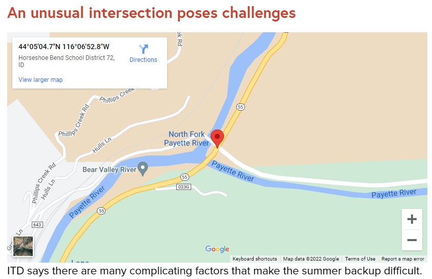
But, as you come down Banks-Lowman Road you slow to a stop behind a sea of brake lights. Nothing moves for minutes at a time, until you can crawl ahead a car’s length toward the intersection with Highway 55.
This is the scene at the busy intersection many Sunday afternoons in the summer months as vacationers return to the Treasure Valley from getaways in McCall and Cascadee. The seemingly endless stream of southbound traffic creates long backups on Banks-Lowman Road as travelers are forced to wait for few and far between openings between cars to turn onto the highway and head south.
The Idaho Transportation Department has a study underway of the intersection to evaluate its options to address the backups, which should be completed later this year. The study will examine “viable options” to address the seasonable backups in the area and propose early designs for how to improve the area.
“It’s a major step in outlining the cost of a project and its prioritization in our long-range plan,” ITD spokesperson Jillian Garrigues wrote in an email to BoiseDev.
Flaggers work the intersection on holiday weekends to address traffic problems at the cost of $3,500 per day. In 2022 there were flaggers on the intersection for six days at a cost of $28,000.
But, the study, which was paid for with a grant from the Federal Highway Administration, doesn’t mean the project will get done. ITD would still need more funds to finish the final design, acquire the land to build the project, and complete the construction.
One of the big obstacles to working on the intersection is the one-lane bridge on the west side of the intersection that leads to a boat ramp on the river. Because of the one lane of travel on the bridge, it means cars turning in and out of the bridge need extra time to move in and out, slowing traffic.
A 2018 blog post authored by former ITD spokesperson Jake Melder said a stoplight would also slow traffic down, but in a different way than the current situation. When asked about the intersection, Garrigues pointed BoiseDev to Melder’s blog post as an answer to our inquiries.
“Another concern is that a signal will force the currently free-flowing traffic on ID-55 to stop,” Melder said. “This creates a queue. As that queue backs up, major safety concerns arise. Imagine a driver coming down the mountain going 55mph, turning a corner and suddenly coming upon break lights. A signal adds new safety and mobility concerns, with every bit as much risk of serious injury as the existing condition, and possibly more overall delay for travelers.”
A roundabout would also help ease the congestion at the intersection on holiday weekends, but they require a large area to operate in. This intersection is currently bounded by rivers and steep mountainsides, which ITD says leaves it little room to construct a roundabout. Roundabouts also require two lanes of travel in and out to allow for proper and safe passing, but the one-lane bridge complicates this because it wouldn’t have a way for two lanes of traffic to turn right onto the bridge. Boise County, not ITD, owns the bridge.
“Things are very tight with three of the quadrants bordered by rivers and the last hugging a mountainside,” Melder wrote in his blog post. “A roundabout would either require a massive bridge structure or significant carving out of the mountainside.”
 The third option under study would add a third lane for southbound traffic open for left-turning traffic from Banks-Lowman. Then, once someone turns onto the highway they could use that third lane to gain speed and merge onto Highway 55.
This would require the construction of a new, wider bridge on the southern end of the intersection to make room for the third lane. In order to fit a wider bridge into the area, ITD would have to cut into the mountainside both north and south of Banks-Lowman to add space for the lane.
“The silver lining for this option is the age of the bridge on ID-55,” Melder wrote. “Though it is safe today, it will have to be replaced in the near future due to its age and condition. Replacing it with a wider bridge becomes much more cost-effective at that time. Currently, this bridge is not scheduled for replacement in our 7-year plans.”
ITD says the combination of relatively low traffic counts on the corridor and low rates of deadly crashes at the intersection makes it hard to get “the most bang for the taxpayers” buck.
In July, average weekday traffic at the intersection was roughly 10,400 vehicles, and the numbers climbed to 13,201 on weekends, split equally going north and south. This is up from 6,500 cars traveling this stretch on a typical summer weekday in 2018, as Melder reported in his blog post.
By comparison, 28,273 vehicles traveled past the old HP Campus on Highway 20 in July on the average weekday and 19,284 on weekends. On Highway 16 south of Highway 44, 22,149 vehicles moved through the area on an average weekday in July. Another 16,318 drove the stretch on the average weekend in July.
Melder’s blog post also reported only five crashes at the Banks-Lowman and Idaho 55 from 2013-2017, the latest data at the time of his blog post. Of those, two resulted in only damage to vehicles, two ended with minor injuries, the final crash had one “serious injury” and two people walked away with minor injuries. There was also a sixth deadly crash in 2018 where one person died.
ITD says at the time in 2018 the Banks-Lowman intersection did not rate in the top 1,000 intersections statewide for frequency and severity of crashes.
“As we consider all of these actions, we have to weigh the cost/benefit,” Melder wrote in 2018. “The long-range options explored above will cost tens of millions of dollars. And in the context of crash data and congestion, it is far from our highest priority. That does not eliminate the possibility of making improvements, it just makes it much harder.”