

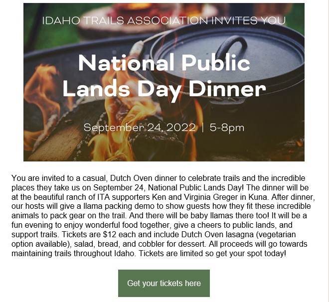
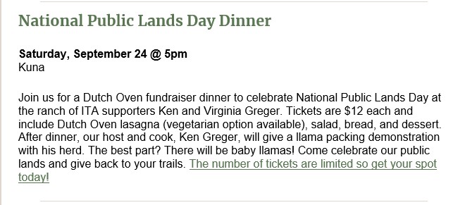
Join us for a Dutch Oven dinner to celebrate National Public Lands Day at the beautiful ranch of ITA supporters Ken and Virginia Greger. Tickets are $12 each and include Dutch Oven lasagna (vegetarian option available), salad, bread, and dessert. After dinner, our host and cook, Ken Greger, will give a llama packing demonstration with his herd. The best part? There will be baby llamas! Come celebrate our public lands and give back to your trails. The number of tickets are limited so get your spot today! Ticket sales will close Friday, September 23.
Doors open 5:00pm, dinner will be served at 5:30pm.
BYOB: Lemonade and water will be available but feel free to bring your own alcoholic drinks if you’d like.
Location: Ken and Virginia Greger’s Ranch, 2011 S. Luker Rd, Kuna, ID 83634
https://edits.nationalmap.gov/apps/gaz-domestic/public/all-official-sq-names

The U.S. Department of Interior’s Board on Geographic Names has voted to approve replacement names for 650 places across the West, including Idaho, that included the slur “sq—.”
The board voted Thursday to approve the replacement names, including 71 places in Idaho, as part of an effort to remove the term from federal use, according to a press release issued by the U.S. Department of Interior. Department officials said the term is used as an offensive ethnic, racist and sexist slur for Indigenous women.
“I feel a deep obligation to use my platform to ensure that our public lands and waters are accessible and welcoming. That starts with removing racist and derogatory names that have graced federal locations for far too long,” Secretary of Interior Deb Haaland said in a written statement. “I am grateful to the members of the Derogatory Geographic Names Task Force and the Board on Geographic Names for their efforts to prioritize this important work. Together, we are showing why representation matters and charting a path for an inclusive America.”
The vote came after the Derogatory Geographic Names Task Force spent months reviewing public comment and recommendations from 70 tribal governments that participated in the process, U.S. Department of Interior officials said. Overall, the task force received more than 1,000 recommendations for name changes, including several different recommendations for some of the same places or features.
The new names are in place effective immediately for federal use, officials said.
In Idaho, the changes included renaming 14 different streams named “Sq— Creek” and giving them new names that include Priest Stream, Chief Eagle Eye Creek, Pia Soko Naokwaide, Yeva Agai Naokwaide and Newe Waippe Naokwaide.
Other examples include replacing the name “Sq— Mountain” for two different mountains, which are now called Willow Spring Mountain and Spring Valley Mountain. Four other mountains named “Sq— Peak” were also renamed Santa Rita Peak, Wheatfield Mountain, Sierra Ancha Peak, and Porcupine Mountain.
The complete list of places with replacement names is available on the U.S. Geographic Survey website.
Margaret Carmel – BoiseDev Sr. Reporter
Date: September 13, 2022
Picture it: You’ve just spent a relaxing, but tiring weekend hiking in Garden Valley and all you can think about is hitting the hay at home in the Treasure Valley.
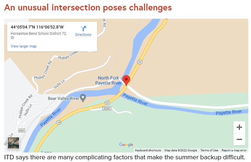
But, as you come down Banks-Lowman Road you slow to a stop behind a sea of brake lights. Nothing moves for minutes at a time, until you can crawl ahead a car’s length toward the intersection with Highway 55.
This is the scene at the busy intersection many Sunday afternoons in the summer months as vacationers return to the Treasure Valley from getaways in McCall and Cascadee. The seemingly endless stream of southbound traffic creates long backups on Banks-Lowman Road as travelers are forced to wait for few and far between openings between cars to turn onto the highway and head south.
The Idaho Transportation Department has a study underway of the intersection to evaluate its options to address the backups, which should be completed later this year. The study will examine “viable options” to address the seasonable backups in the area and propose early designs for how to improve the area.
“It’s a major step in outlining the cost of a project and its prioritization in our long-range plan,” ITD spokesperson Jillian Garrigues wrote in an email to BoiseDev.
Flaggers work the intersection on holiday weekends to address traffic problems at the cost of $3,500 per day. In 2022 there were flaggers on the intersection for six days at a cost of $28,000.
But, the study, which was paid for with a grant from the Federal Highway Administration, doesn’t mean the project will get done. ITD would still need more funds to finish the final design, acquire the land to build the project, and complete the construction.
One of the big obstacles to working on the intersection is the one-lane bridge on the west side of the intersection that leads to a boat ramp on the river. Because of the one lane of travel on the bridge, it means cars turning in and out of the bridge need extra time to move in and out, slowing traffic.
A 2018 blog post authored by former ITD spokesperson Jake Melder said a stoplight would also slow traffic down, but in a different way than the current situation. When asked about the intersection, Garrigues pointed BoiseDev to Melder’s blog post as an answer to our inquiries.
“Another concern is that a signal will force the currently free-flowing traffic on ID-55 to stop,” Melder said. “This creates a queue. As that queue backs up, major safety concerns arise. Imagine a driver coming down the mountain going 55mph, turning a corner and suddenly coming upon break lights. A signal adds new safety and mobility concerns, with every bit as much risk of serious injury as the existing condition, and possibly more overall delay for travelers.”
A roundabout would also help ease the congestion at the intersection on holiday weekends, but they require a large area to operate in. This intersection is currently bounded by rivers and steep mountainsides, which ITD says leaves it little room to construct a roundabout. Roundabouts also require two lanes of travel in and out to allow for proper and safe passing, but the one-lane bridge complicates this because it wouldn’t have a way for two lanes of traffic to turn right onto the bridge. Boise County, not ITD, owns the bridge.
“Things are very tight with three of the quadrants bordered by rivers and the last hugging a mountainside,” Melder wrote in his blog post. “A roundabout would either require a massive bridge structure or significant carving out of the mountainside.”
 The third option under study would add a third lane for southbound traffic open for left-turning traffic from Banks-Lowman. Then, once someone turns onto the highway they could use that third lane to gain speed and merge onto Highway 55.
This would require the construction of a new, wider bridge on the southern end of the intersection to make room for the third lane. In order to fit a wider bridge into the area, ITD would have to cut into the mountainside both north and south of Banks-Lowman to add space for the lane.
“The silver lining for this option is the age of the bridge on ID-55,” Melder wrote. “Though it is safe today, it will have to be replaced in the near future due to its age and condition. Replacing it with a wider bridge becomes much more cost-effective at that time. Currently, this bridge is not scheduled for replacement in our 7-year plans.”
ITD says the combination of relatively low traffic counts on the corridor and low rates of deadly crashes at the intersection makes it hard to get “the most bang for the taxpayers” buck.
In July, average weekday traffic at the intersection was roughly 10,400 vehicles, and the numbers climbed to 13,201 on weekends, split equally going north and south. This is up from 6,500 cars traveling this stretch on a typical summer weekday in 2018, as Melder reported in his blog post.
By comparison, 28,273 vehicles traveled past the old HP Campus on Highway 20 in July on the average weekday and 19,284 on weekends. On Highway 16 south of Highway 44, 22,149 vehicles moved through the area on an average weekday in July. Another 16,318 drove the stretch on the average weekend in July.
Melder’s blog post also reported only five crashes at the Banks-Lowman and Idaho 55 from 2013-2017, the latest data at the time of his blog post. Of those, two resulted in only damage to vehicles, two ended with minor injuries, the final crash had one “serious injury” and two people walked away with minor injuries. There was also a sixth deadly crash in 2018 where one person died.
ITD says at the time in 2018 the Banks-Lowman intersection did not rate in the top 1,000 intersections statewide for frequency and severity of crashes.
“As we consider all of these actions, we have to weigh the cost/benefit,” Melder wrote in 2018. “The long-range options explored above will cost tens of millions of dollars. And in the context of crash data and congestion, it is far from our highest priority. That does not eliminate the possibility of making improvements, it just makes it much harder.”


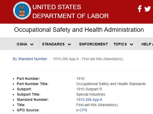
The following list sets forth the minimally acceptable number and type of first-aid supplies for first-aid kits required under paragraph (d)(2) of the logging standard. The contents of the first-aid kit listed should be adequate for small work sites, consisting of approximately two to three employees. When larger operations or multiple operations are being conducted at the same location, additional first-aid kits should be provided at the work site or additional quantities of supplies should be included in the first-aid kits:
1. Gauze pads (at least 4 x 4 inches).
2. Two large gauze pads (at least 8 x 10 inches).
3. Box adhesive bandages (band-aids).
4. One package gauze roller bandage at least 2 inches wide.
5. Two triangular bandages.
6. Wound cleaning agent such as sealed moistened towelettes.
7. Scissors.
8. At least one blanket.
9. Tweezers.
10. Adhesive tape.
11. Latex gloves.
12. Resuscitation equipment such as resuscitation bag, airway, or
pocket mask.
13. Two elastic wraps.
14. Splint.
15. Directions for requesting emergency assistance.
[59 FR 51672, Oct. 12, 1994; 60 FR 47022, Sept. 8, 1995]

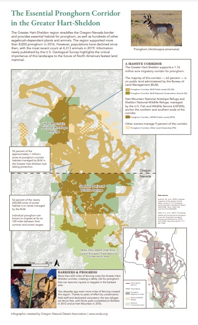
The Greater Hart-Sheldon region straddles the Oregon-Nevada border and provides essential habitat for pronghorn, as well as hundreds of other sagebrush-dependent plants and animals. In 2016, the region supported more than 8,000 pronghorn. However, populations have declined since then, with the most recent count at 4,313 animals in 2019.
As information newly published by the U.S. Geological Survey highlights, this landscape is critically important to the future of North America’s “prairie ghost.” ONDA used this GIS data to create the map below, which highlights how much of the migration corridor lacks a strong protective status and how many miles of fencing still cross this corridor.