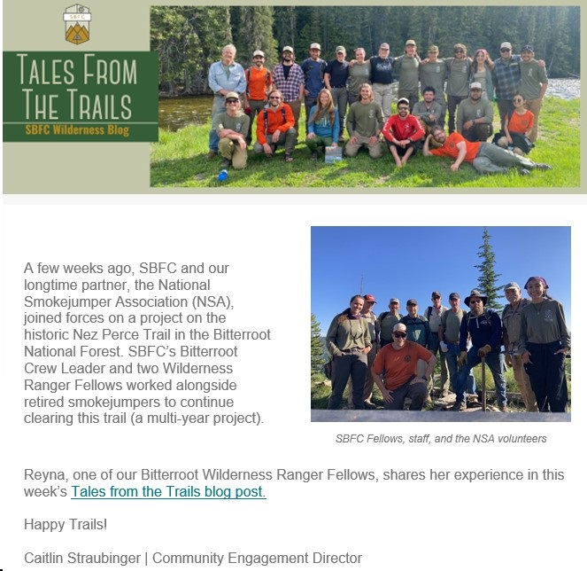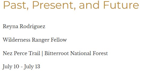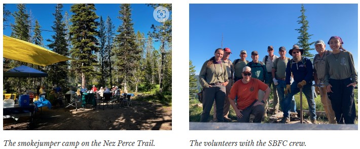
Submitted by Lisa Griffith
READ FULL REPORT: Report out on the Tin Cup project
Suggested by Marc and Tyler Kelly
Tyler’s Boy Scout Troop is working on their Wilderness Survival Merit Badge.
Written by Steve Belcher
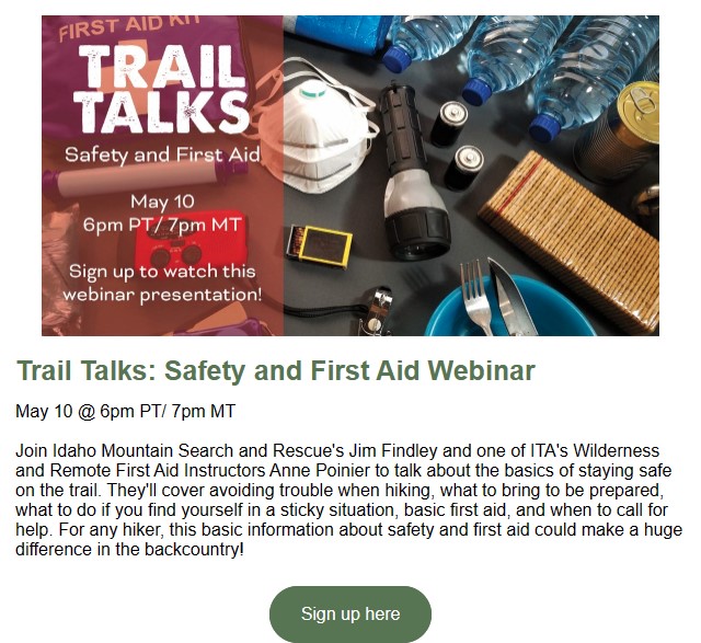
It’s healthy to get outside and enjoy hobbies like hiking, biking, climbing, riding horses, and camping. However, all of these outdoor activities come with potential risks and challenges, so it’s essential for anyone who plans to spend plenty of time outside to understand the basics of outdoor first aid. The principles of first aid are the same no matter where you are, but outdoors, the practical application can look very different. You’ll need to be resourceful enough to both bring what you might need and use what you have at hand in order to stabilize someone’s condition in an emergency.
Being well-versed in wilderness first aid is an important life skill if you plan to go on outdoor adventures. Not only does it help you become more self-sufficient and capable, but it can be a life-saving skill in certain situations. The majority of outdoor injuries are minor and easily treatable with a first aid kit, but that isn’t always the case. In some situations, knowing first aid can make a world of difference, especially since there aren’t any emergency responders close by in the wilderness. You don’t need to be a professional doctor or nurse, but you do need to have the equipment and the knowledge to be able to keep someone’s condition from worsening until you can get help.
No matter where you go, you should always have a first aid kit handy. Stock your kit with your trip in mind, thinking about the types of situations you could encounter as well as how long you’ll be gone. The longer your trip will be, the bigger your kit should be. The kit should be well-organized so that everything you need is easy to find; you don’t want to waste precious time rummaging around for what you need in an emergency situation. Consider using different-colored containers and clear labels to organize your supplies. You should also make sure that everything is packed to withstand the elements.
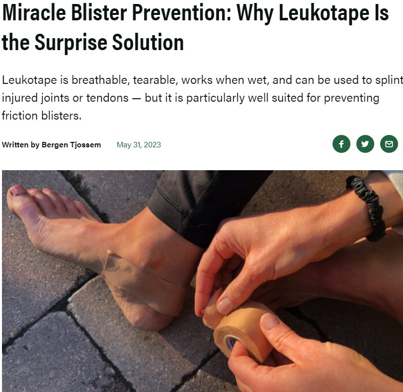
Wounds can range in severity from minor scrapes to serious injuries. Without proper care, there’s a risk of infection or even death. When someone is wounded, the basic steps of wound care are to get the bleeding under control, do what you can to prevent infection, and take measures to promote proper healing. You’ll want to bring along supplies such as bandages of different sizes, gauze, antiseptic, and antibiotic ointment.
When you’re out on the trail, it’s not always easy to remember to keep drinking water like you should, and overexposure to the sun is a real possibility. When someone gets overheated, dehydration and heat stroke are real possibilities, and both of these conditions can endanger your health. Heat stroke occurs when people don’t sweat enough to lower their body temperature, and it’s incredibly common in people who are outdoors a lot. It can often come on rapidly, and it requires immediate medical attention. Always bring more water than you think you’ll need on your trip. If someone becomes overheated, find or create a shady spot where the person can rest, give them water, and use some of the water you have on hand on their skin to help cool them down. Then, head back to civilization so the person can get professional medical treatment.
If someone gets burned in the wilderness, remember the four C’s: Cool it, clean it, cover it, and call for help. Cool the burn using cool water; the longer heat stays in the body tissue, the deeper the burn becomes. Then, clean the burn with soap and water. Cover the burned area with antibacterial ointment, then apply a non-stick bandage to protect the burn. If you don’t have a bandage, cover the burn with a makeshift bandage using whatever you have, such as a clean shirt or a sock; it’s crucial to keep more bacteria in the environment from getting into the wound. Once the burn is covered, get help from a professional as soon as you can.
Almost three-quarters of all non-fatal wilderness injuries are broken bones or sprains. It’s incredibly common to sprain an ankle on a steep trail or trip and fall on a limb, causing a broken bone. It can be hard to diagnose these injuries in the wilderness, but often, you can help to reduce greater injury by using the RICE method: rest, ice, compression, and elevation. Reduce the swelling by icing the area with anything you have on hand, whether that’s water from a stream, water from a bottle, or even snow. Compress the injured area with a bandage, bandanna, or clean clothes, but make sure you don’t tie it too tightly; you don’t want to cut off circulation. If you suspect a broken bone, apply a splint to immobilize the area. Elevate the injury above the heart, even if that requires you to sit down on a trail and let people pass you by. This should be done for at least 20 minutes before attempting to have the injured person move again. It may be necessary to use a hiking pole or big stick to help with balance or bear some weight while you make your way back to civilization. RICE should be repeated every two hours on the walk back to help reduce the seriousness of the injury.
In the event of cardiac arrest in the wilderness, chest compressions should be initiated right away. However, it’s important to be realistic about the situation, given the circumstances you may be in. For instance, usually, you should keep going with CPR until help arrives or until you’re too exhausted to continue. But if you’re hours or even days away from civilization, you should know that the effectiveness of CPR decreases rapidly after 20 to 30 minutes.
Hypothermia due to environmental exposure is common in wilderness settings. Any temperature below 98.6 degrees Fahrenheit can be linked to hypothermia, but it’s especially common in below-freezing temperatures. It’s also possible to get hypothermia in temperatures around 40 degrees if you’re exposed to heavy wind and rain. It’s easy to lose body heat, especially for people who aren’t dressed correctly, people who get wet by accident, people who are dehydrated or have poor food intake, and people who are fatigued. The severity of hypothermia (mild, moderate, or severe) can be assessed by asking the person questions that require higher reasoning; seeing if their shivering can be stopped voluntarily; checking to see whether or not you can get a pulse on their wrist (if you can’t, that may indicate a core body temperature lower than 86 degrees); and seeing whether the person can be taken out of the fetal position. Hypothermia can be treated by reducing heat loss by adding clothes or changing into dry clothes; adding fuel and fluids like hot liquids, carbs, and proteins; and getting the person warmth from a fire or another external heat source.
Knowing what can be done to help nurse somebody back to health using first aid is essential in an emergency, but it’s not the only thing you can do. Before you go on your trip, make sure that you’ll be able to summon help if you need it. For short trips close to civilization, bringing a fully charged phone may be sufficient. But if you’re heading farther afield, get a personal locator beacon. These devices can be activated in an emergency to send out a distress call by satellite. While you wait for help to arrive, do your best to stay calm and administer first aid as best as you can.
Good Evening,
Just wanted to remind everyone of Tuesday’s meeting. We will have the horse council office open as well as zoom. I know it’s still a busy time of year for many. Below are the topics I am wishing to discuss, please see the attached documents for review. If you cannot attend and want to chat or share thoughts and ideas feel free to reach out to me.
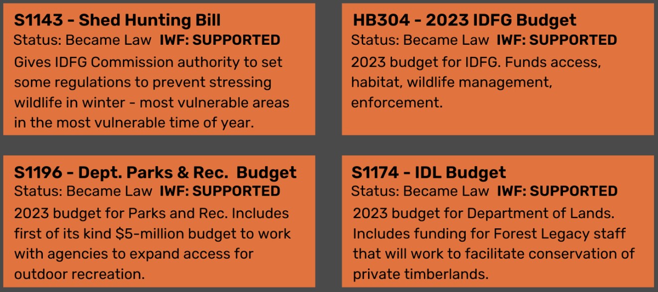
1. Updated Info Graphic
2. Proposed Legislation
3. Proposed date of Oct 17th for the next trails summit at Gowen Field.
The Zoom link is below, also this is a recurring link so this link will continue to be the one to use.
Respectfully,
Dan Waugh
360-791-1591
Idaho Horse Council Administrator is inviting you to a scheduled Zoom meeting.
Funding Infogrpahic – July 18 draft
Draft legislation-Non motorized trail funding
Topic: IHC Idaho Non-Motorized Trails Initiative
Time: Aug 15, 2023 10:00 AM Mountain Time (US and Canada)
Every month on the Third Tue, 12 occurrence(s)
Aug 15, 2023 10:00 AM
Sep 19, 2023 10:00 AM
Oct 17, 2023 10:00 AM
Nov 21, 2023 10:00 AM
Dec 19, 2023 10:00 AM
Jan 16, 2024 10:00 AM
Feb 20, 2024 10:00 AM
Mar 19, 2024 10:00 AM
Apr 16, 2024 10:00 AM
May 21, 2024 10:00 AM
Jun 18, 2024 10:00 AM
Jul 16, 2024 10:00 AM
Please download and import the following iCalendar (.ics) files to your calendar system.
Join Zoom Meeting
https://us02web.zoom.us/j/88035040972?pwd=OERKMk1pT2dnWEFEVFRNMGJKRVhaUT09
Meeting ID: 880 3504 0972
Passcode: 225301
Find your local number: https://us02web.zoom.us/u/kevE8IGp8z
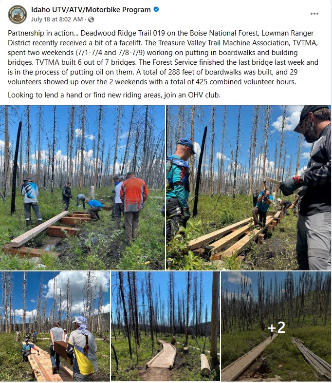
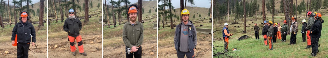
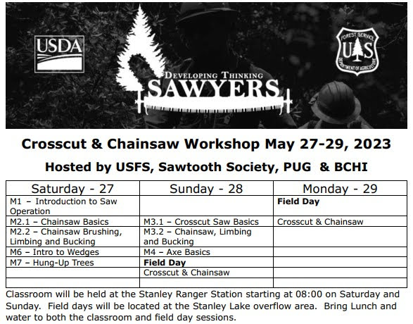
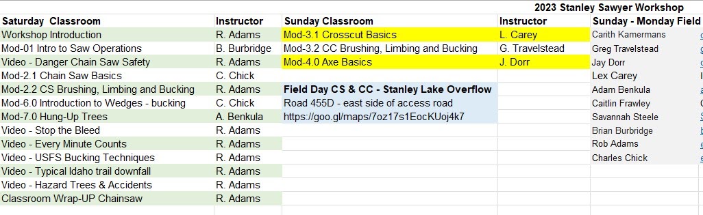
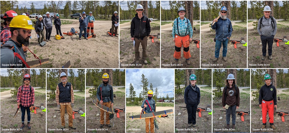
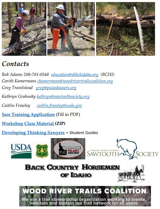
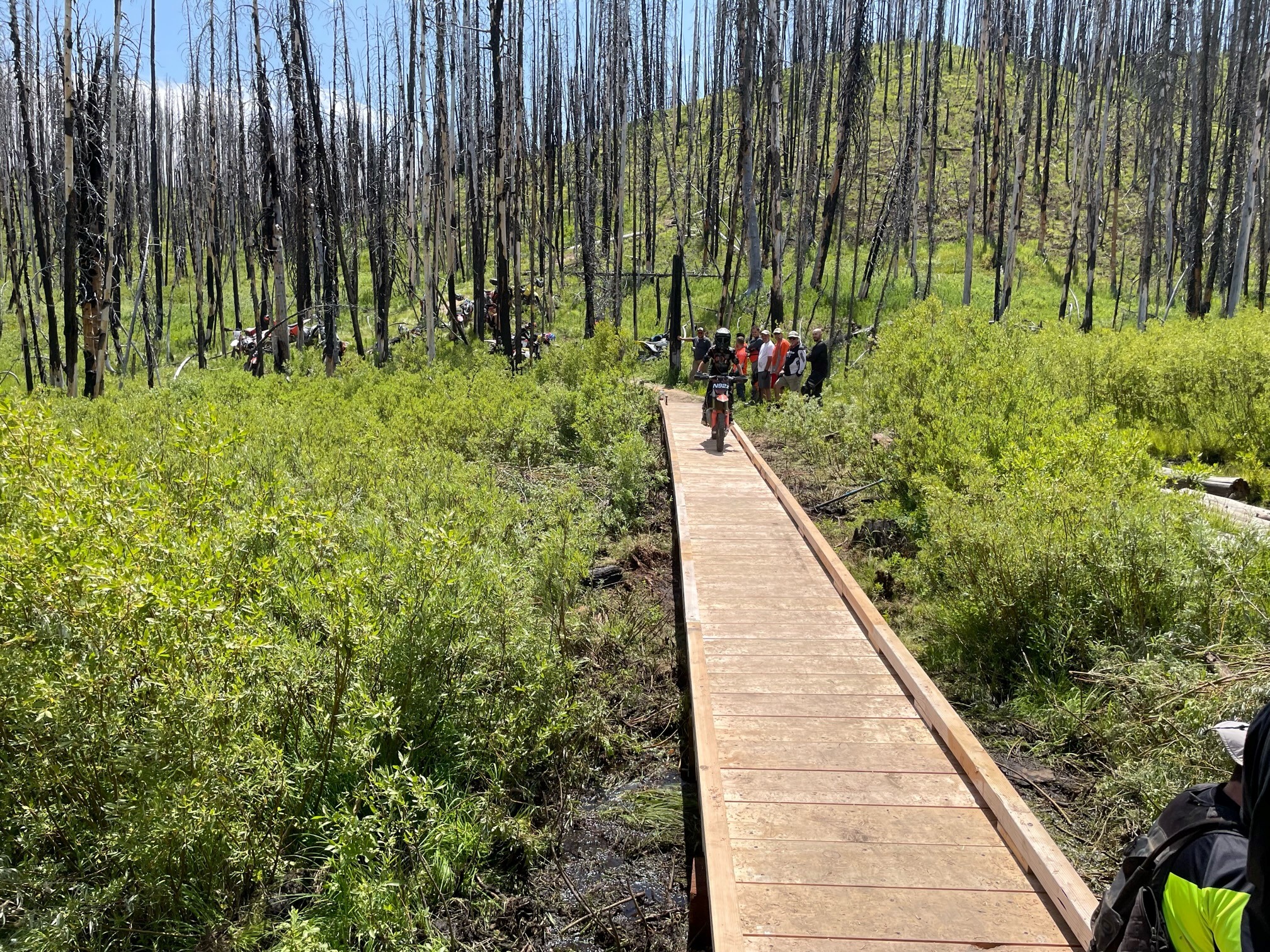
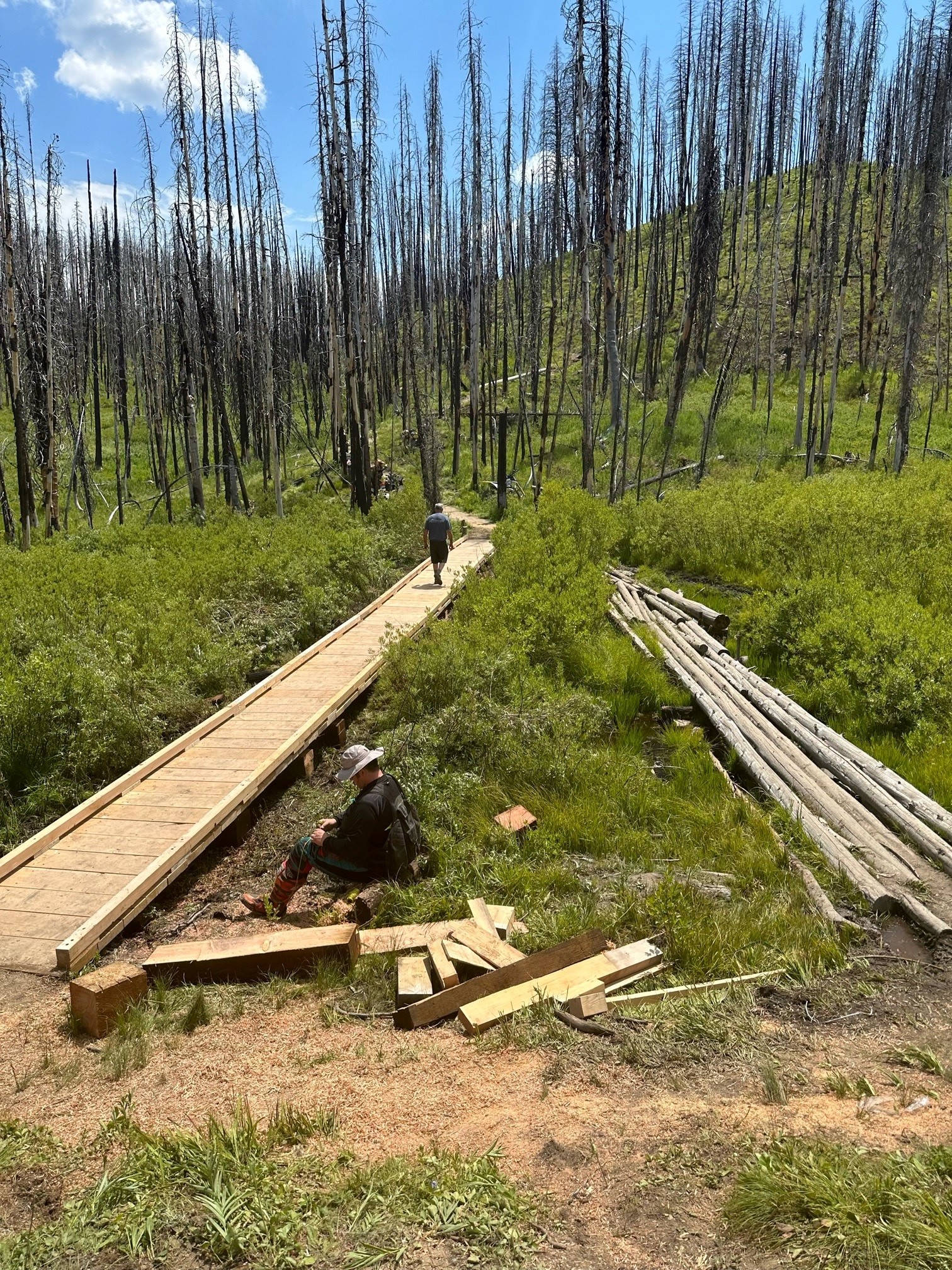
Several TVTMA members worked this project had been certified at the Thinking Sawyer Workshops lead by BCHI. This trail with its many boggy spots has been a notorious horse-swallower I’ve heard, not too good for bikes either. More areas to do since conditions have changed since the 2017 scoping finally implemented, but I think horse use is going to be much less risky now with the replacement and new puncheon at 7 sites.
Notably, the upper 3 miles of the trail above Whitehawk meadow that was impassible, blown-in for several years with endless deadfall, is now open at the hands of a number of your new or recertified students.
Your efforts are now multiplied in a measurable return to the users. Lots of folks are pretty pleased about this outcome and are looking at it is a template for future projects and partnering with FS to improve recreational access.
One of the details, left out for brevity, is that the northern-most portion of Tr019 –about 2.5 miles, had been inaccessible due to extensive deadfall for an unknown number of years. From its intersection with Tr021 at Whitehawk Basin to road 510, that trail is now cleared of deadfall, with new puncheons installed at planned sites, and now usable by all single-track users after years of being effectively “closed-and-stored” by nature. That’s worth celebrating.
Granted there’s more to do on other parts of the trail not covered by the original project scope, conditions having evolved since the original proposal (2017?) of the project now implemented. So we’ll look forward to working with the Forest and Lowman RD on continuing improvements along this popular trail and its interconnects. My understanding is that Mike Lindenfelser is working on trailhead sign replacements, and that will be an ongoing task to put a bow on this current effort.
JT Wagner and his crew of two seasonal and two interns should also be noted for their significant contribution to the timely and quality completion of the project. Their contribution was a force-multiplier and expediting factor, which we were not originally counting on when anticipating a three-weekend work plan.
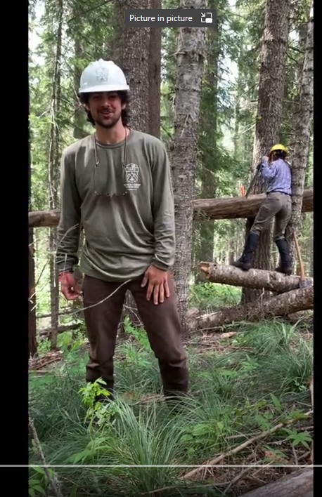
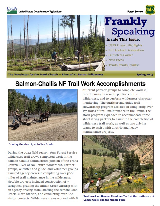
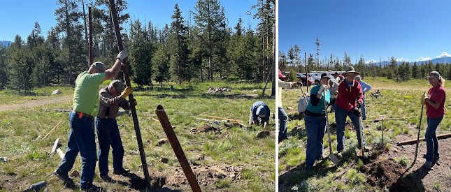
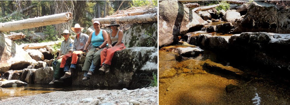
Pictures from the 2023 Project
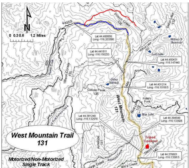
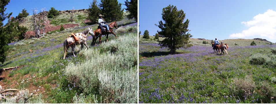
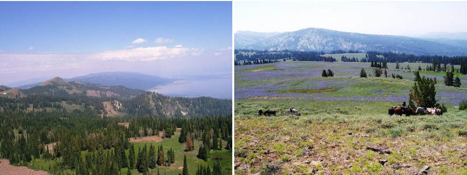
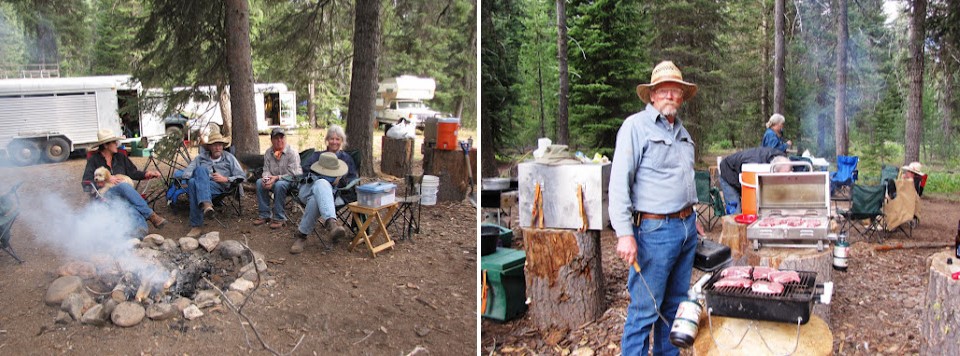
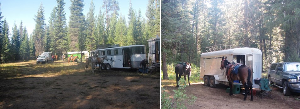
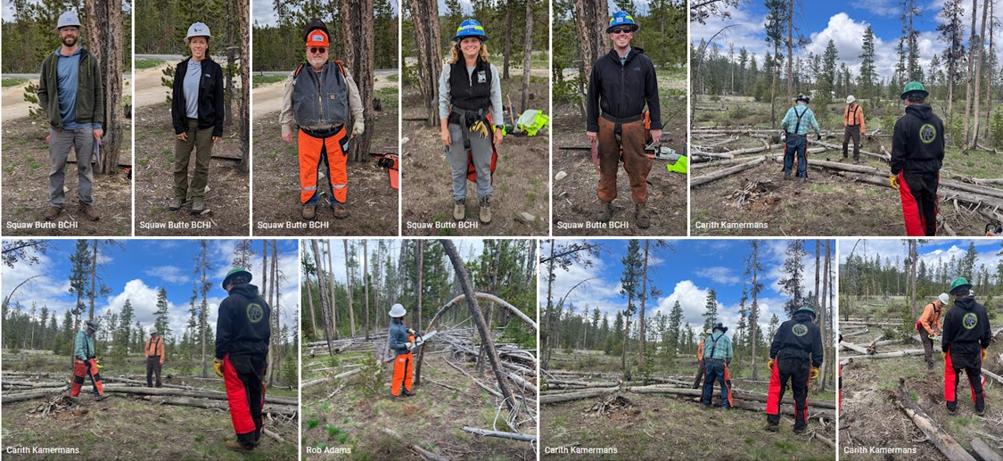
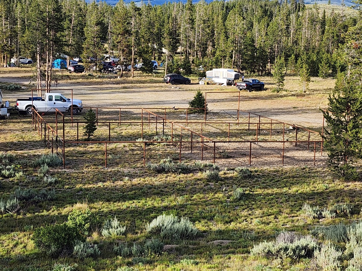
Trail Project – Saturday & Sunday August 19-20, 2023 ( Trail Project & Horse Camping)
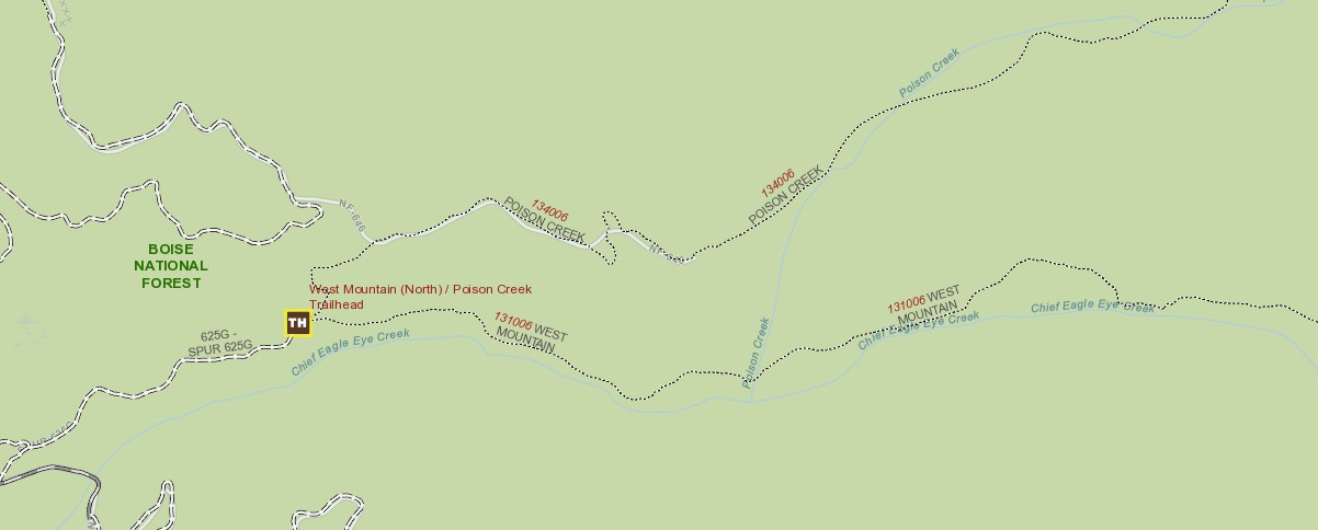
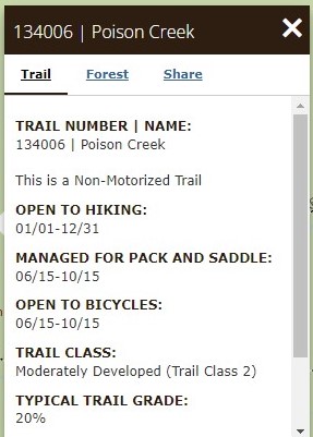
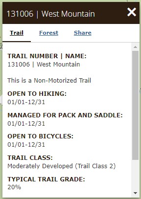
Location: Chief Eagle Eye Creek (west mountain north), & Poison Creek West Mountain, North of Ola, ID
GPS USFS[131] USFS[134] MAP Pictures 2021 SC-2020 PC-2020
Work will concentrate on Poison Creek Trail – which needs extensive brushing)
Great horse camping area with some fun but challenging trails. Most people arrive at the camp site on Friday night.
Potluck meals Breakfast (Sat & Sun), Dinner (Sat) – Bring lunches, We will be working on Saturday with a short fun ride on Sunday!
Contact: Rob Adams 208-781-0548 projects@sbbchidaho.org
SIGN UP: https://www.supersaas.com/schedule/sbbchidaho/Squaw_Butte_Events

Marjaliisa Waugh and her string of Welch ponies & mules
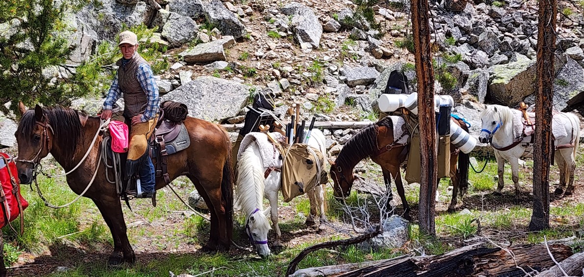
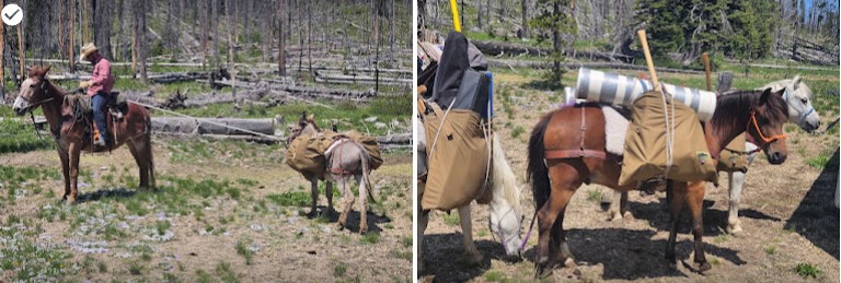
Jun – SBFC Pack Support – Sulphur Creek
Jul – ITA Pack Support – Little Queens
Jul – ITA Seven Devils Pack Support
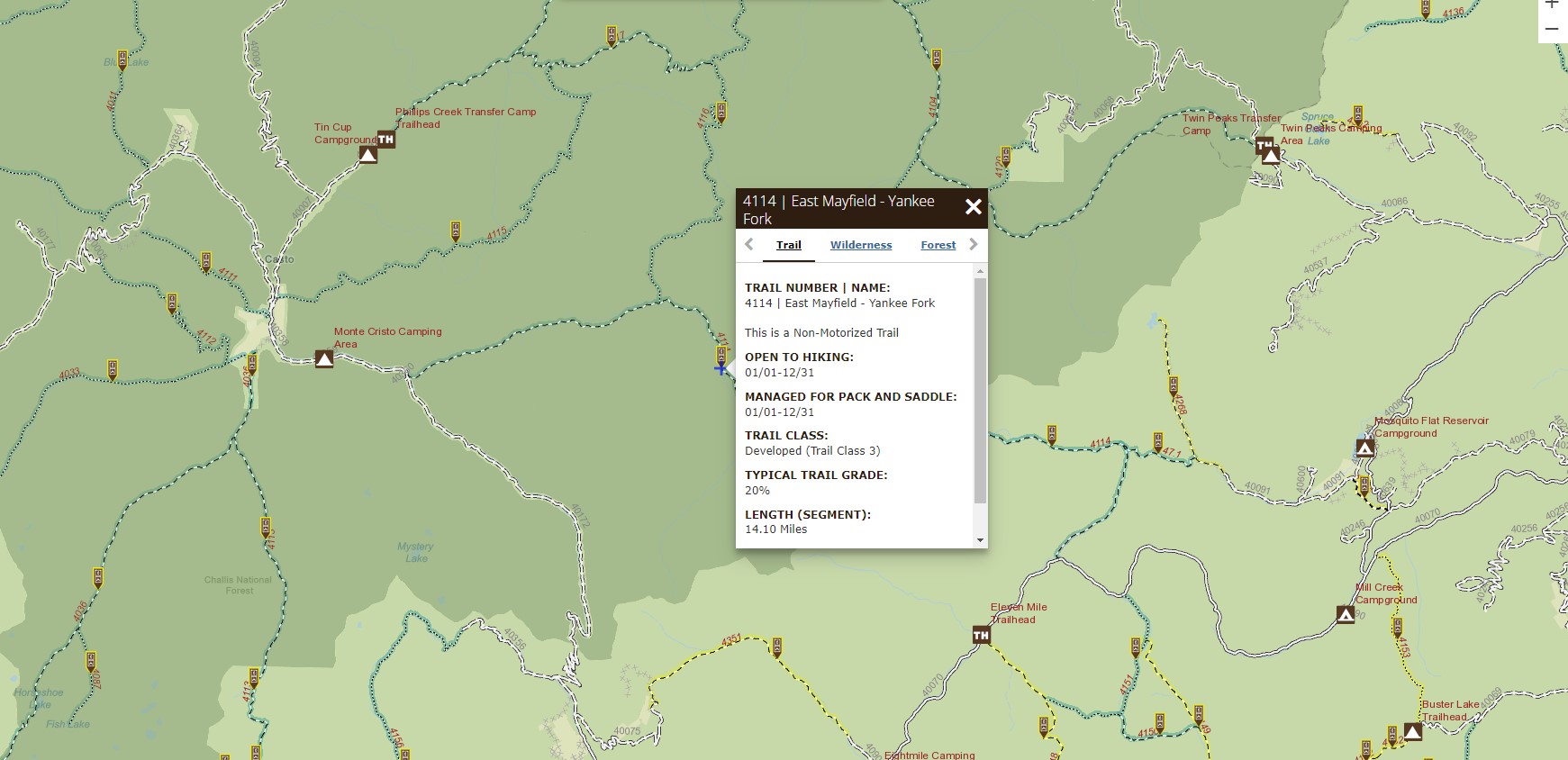
Jul – PUG East Mayfield Creek Pack Support
LandTrust.com, which was founded in 2019, promises to connect outdoor recreationists with private landowners, most often for hunting or fishing but also for activities like hiking, bird watching and more. The Montana-based business allows owners to list their properties and name their price for various hobbies.
LandTrust founder and CEO Nic De Castro told the Idaho Statesman in an email that the service is a win-win for outdoor enthusiasts and landowners, the majority of whom De Castro said are “owner/operator, multigenerational farms and ranches.”
The idea has drawn concern from some outdoor recreation experts, especially over its affiliation with Dan and Farris Wilks, the Cisco, Texas, oil tycoons who gated off roads across their properties. But LandTrust has also garnered support over its potential to benefit struggling farmers and ranchers.
According to financial news site FinSMEs, the Wilkses led a $6 million Series A funding round, a fundraising effort in which stock is issued to investors, earlier this year. The website reported that LandTrust planned to use the funds to expand into five more states. Currently, it partners with landowners in more than a dozen states, primarily in the Midwest, Intermountain West and South.
The Wilks brothers, who earned billions selling a fracking company, gained prominence in Idaho and Montana in the late 2010s after buying tens of thousands of acres across several properties. In multiple instances, they erected gates at their property boundaries to block access on roads that had long been used by the public — and which some critics say are public rights-of-way that were illegally blocked off.
The Wilkses also backed a controversial 2018 law that hiked penalties for trespassing on private property.
Now Idaho residents can access some of their properties through LandTrust. Three properties are listed on the site under the name “DF D” — referencing DF Development, the name of one of the brothers’ businesses. Two of the properties are near Idaho City, and the other is near New Meadows. All of the listings say they are new additions to the site.
Booking the sites could cost as much as $4,300 for five days of self-guided hunting or $4,500 for bear hunting with a guide, according to the listings. Other activities include shed hunting for around $100 per day, bird watching and wildlife photography for $82 per guest per day, or $35 per guest per day for “outdoor recreation.”
The Wilkses’ listings make up a combined 8,600 acres — about 70% of the 12,000 acres De Castro said LandTrust lists in Idaho.
Though the brothers drew the ire of many Idaho hunters in years past, De Castro said he has no reservations about working with the pair.
“Yes, the Wilks (brothers) are very large private landowners, but we treat them just like any other landowner who chooses to facilitate controlled recreation access to their land through LandTrust,” De Castro told the Idaho Statesman.“If you believe in property rights, why should they be treated any differently?
“As far as reputation, we have multigenerational landowners who’ve bordered Wilks properties for years and have said that they’re good neighbors,” he added. “Their opinion carries weight with us.
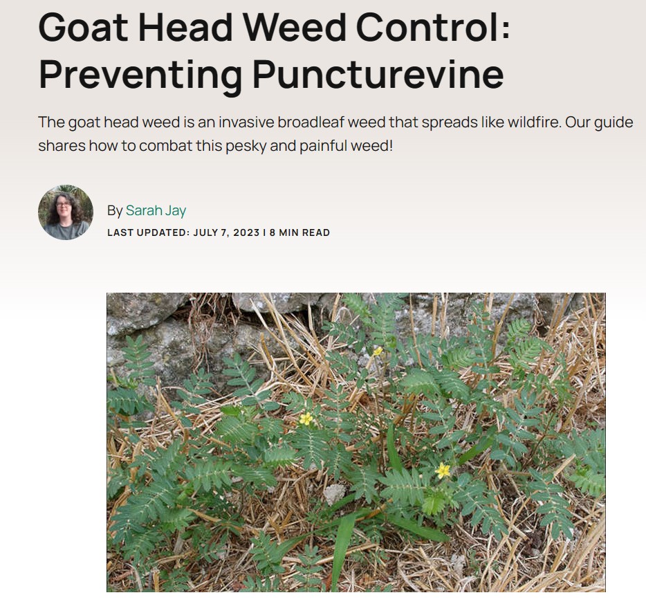 One noxious weed a lot of gardeners deal with is the dreaded goat head weed. This weed forms a dense mat that overtakes almost any planting area and causes a lot of problems. Especially among garden beds where you grow ground cover, look out for this plant.
The first recorded instance of goat head weed occurred in California in 1902. As the decades went on, horticulturists noticed the noxious weed formed monocultures that outcompeted native plants. This led to the classification of the plant as an invasive species.
With that in mind, identification and removal of the dreaded goat head weed are on every one of us who grow. Among native habitat conservationists, farmers, and ranchers, we can reduce the chance of invasion by this weed into our gardens, our bare feet, and in the feet of our livestock.
So, what is goat head weed and how do you get rid of it? Read on, and find out! READ MORE
Two types of chemical control suited to removing goat head weed are glyphosate and oryzalin.
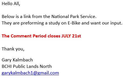
National Park Service studying impacts of E-bikes
National Park Service Studying Impacts Of e-Bikes
Nearly four years after then-Interior Secretary David Bernhardt issued an order to allow eBikes to use the same trails in the National Park System that are open to muscle-powered mechanical bikes, the National Park Service is taking a nationwide look at the impacts of those bikes as required under the National Environmental Policy Act.
The move to conduct the study was required by a court ruling last May that said the Park Service acted in an arbitrary and capricious manner in 2019 in opening parks to eBikes.
In an evening directive, Bernhardt in August 2019 had decreed that “E-bikes shall be allowed where other types of bicycles are allowed; and E-bikes shall not be allowed where other types of bicycles are prohibited.”
In issuing the order, Bernhardt said the decision “simplifies and unifies regulation of electric bicycles (e-bikes) on Federal lands managed by the Department and also decreases regulatory burden.” In the wake of that ruling, the acting director of the Park Service, P. Daniel Smith, issued a directive ordering parks to treat e-Bikes “used for transportation and recreation in a similar manner to traditional bicycles” without requiring either an environmental assessment or more strenuous environmental impact statement examining any natural resource impacts from the decision.
However, this approach generated concern from groups that said the National Park Service needed to conduct environmental studies, as required by NEPA, before approving the use of eBikes in the park system.
Kristen Brengel, the National Parks Conservation Association’s senior vice president of government affairs, told the Traveler at the time that implementing a change in where motorized vehicles, including eBikes, can go in the park system requires the Park Service to embark on a rulemaking process, as required under 36 CFR 1.5.
Except in emergency situations, a closure, designation, use or activity restriction or condition, or the termination or relaxation of such, which is of a nature, magnitude and duration that will result in a significant alteration in the public use pattern of the park area, adversely affect the park’s natural, aesthetic, scenic or cultural values, require a long-term or significant modification in the resource management objectives of the unit, or is of a highly controversial nature, shall be published as rulemaking in the FEDERAL REGISTER.
“If eBikes are to be used on trails already designated for bikes, that is completely contrary to the Park Service’s current policy,” said Brengel, adding that a change in policy should be formally reviewed to ensure there are no conflicts with existing user groups.
“How does this affect the rest of the public visiting a park? We want to make sure everyone has a great experience,” she added. “What does (an eBike) do to everyone else’s experience there? That’s why there needs to be a rulemaking and public comment. Depending on what this policy says, it could be completely violating the Park Service’s own regulations and policies.”
Public Employees for Environmental Responsibility went to court over the Park Service’s action, and that led to last May’s ruling against the agency.
“[T]he Smith Directive attempted to avoid conducting any environmental analysis because the park units would do so, and the park units in turn largely declined to conduct additional analysis because the Smith Directive had already suggested that the change was minimal,” Judge Rudolph Contreras wrote in ordering the NEPA review.
While the Park Service would later implement a Final Rule formalizing the “Smith Directive” with some changes, the judge said that the final rule, by failing to require either an environmental assessment or environmental impact study, “commits the classic NEPA error of considering only the effects of what a policy actually directly authorizes rather than the reasonably foreseeable impacts of a policy.”
The Park Service, the judge, “appears to have ‘simply assumed there were [no impacts] because the Final Rule did not authorize any impacts.’”
That ruling led to Tuesday’s announcement by the Park Service that it was preparing a programmatic environmental assessment to evaluate the potential national-level impacts of electric bicycle use in national parks. The comment period is open from June 21 to July 21.
In announcing that review, the agency said that, “E-bikes can have many benefits for parks and visitors including making travel easier, expanding access for those with physical limitations, and providing healthy recreation opportunities. At the same time, the NPS must manage this emerging form of access and recreation, like others that occur in park areas, in a manner that protects park resources, values, and visitors. The PEA evaluates potential impacts to natural and cultural resources, and visitor use and experience, and wildlife on a national scale.”
Currently, NPS regulations authorize park superintendents to allow eBikes, where appropriate, on roads and trails where traditional bicycles are allowed. Public lands designated by Congress as “wilderness areas” remain off-limits to both traditional bicycles and eBikes.
Note that comments will not be accepted by fax, email, or in any way other than those specified above. Comments delivered on external electronic storage devices (flash drives, compact discs, etc.) will not be accepted. Bulk comments in any format (hard copy or electronic) submitted on behalf of others will not be accepted.
EIN: 26-2378789
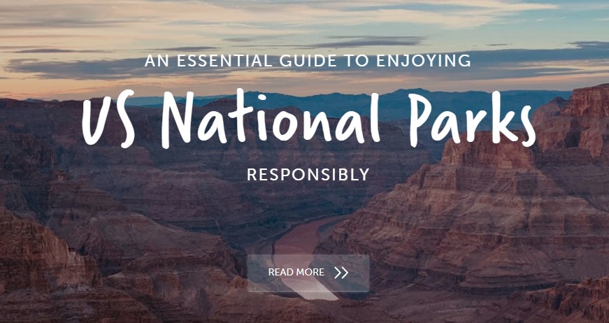
So you want to spend more time outdoors?
Whether you’re a local or a visitor, the US is home to 62 national parks. Yellowstone became the world’s first national park in 1872. And in the years that followed, numerous other areas became national parks and, as part of the Organic Act 1916, the US National Park Service (NPS) was created in 1916 to:
“conserve the scenery and the natural and historic objects and wildlife therein, and to provide for the enjoyment of the same in such manner and by such means as will leave them unimpaired for the enjoyment of future generations.”
NPS is now responsible for more than 400 separate areas making up about 85 million acres, including national parks, national preserves, monuments, recreation areas, seashores, lakeshores, historic parks and sites, parkways, scenic trails, and battlefields.
Within the system, 62 sites are designated as national parks. The selection criteria for national parks includes aspects like unique geological features or unusual ecosystems, recreational opportunities, and, of course, natural beauty. READ MORE
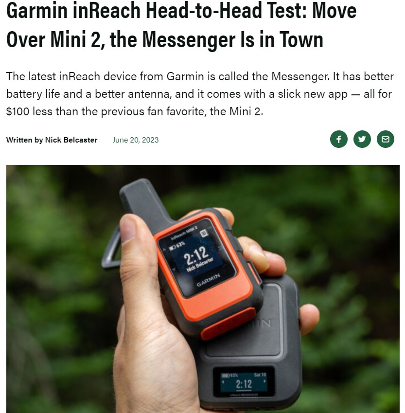
The inReach has long been Garmin’s de-facto line of satellite communication devices. So, when Garmin rolled out the second generation of the inReach Mini, long-time users were excited. The inReach Mini 2 was juiced up with nearly everything on the wishlist: Support for four additional global satellite systems, a new higher-fidelity screen with a quicker refresh rate, and a longer battery life with USB-C charging, to name a few.
But Garmin wasn’t about to stop its inReach innovations there.
The inReach Messenger hit the scene this year, and it did so with a splash. Not so much because the inReach Messenger was built on the devices before it, but because the inReach Messenger is so vastly different from previous iterations. The square black form factor was one obvious diversion from the original design. However, Garmin also changed the way its new device sends and receives messages by adding cell service and Wi-Fi to the mix.
Both devices have the big red button to call in the cavalry if you need help. But most often, you’ll probably be using them to check in with friends and family members, to chat about post-hike dinner plans, or the particular voraciousness of the mosquitos at your camp last night.
As a long-time user of the inReach Mini series, my interest was piqued by the Garmin inReach Messenger. But the question stuck around — Who is this thing for?
In short: After numerous tromps in the hills recently testing both the inReach Min2 and the newer Messenger head-to-head, I’ve come to understand the niche that Garmin has carved out for the Messenger. This is the average person’s satellite messenger device. The Messenger makes messaging easier, it has a longer battery life and a better antenna, and it’s cheaper than other inReach devices. And because it taps into Wi-Fi and cell service when it can, users save those allotted satellite messages for when they really need them.
If you’re one who likes to have backups to your backups, then the inReach Mini 2 is probably a better device for you. The baked-in navigation abilities are only heightened by the accompanying Explore app, but can make it all on their own if push comes to shove.
Fourteen hours of “On” time is also generally going to be enough for most people, especially for those who bring some type of battery bank along on their outdoor adventures.
But for most folks, most of the time, the Garmin inReach Messenger just makes things easier. Your trade-off for the nav tools is an extended burn time, a slightly better antenna, and $100 still nestled in your wallet. And with the new Messenger app, communication is as easy as texting directly from your phone. If things turn ugly and you do need to hit that SOS button, simplicity is your best friend.
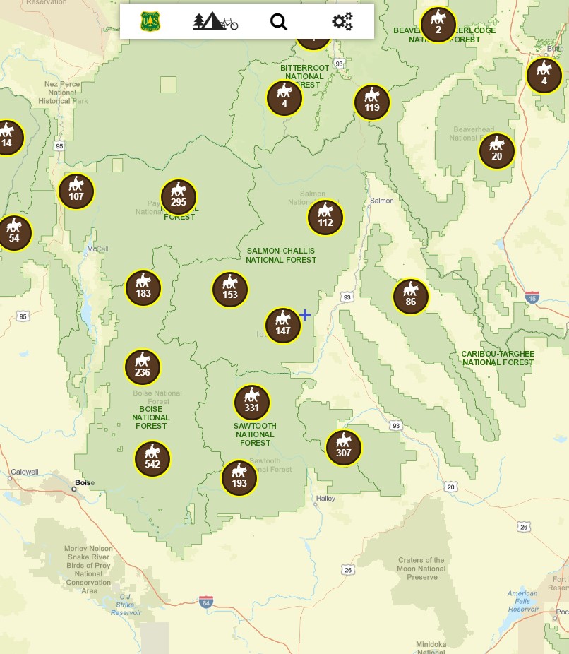
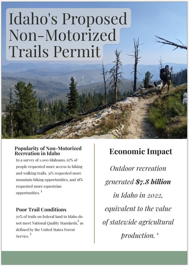
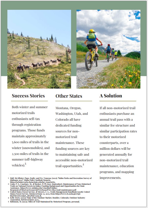
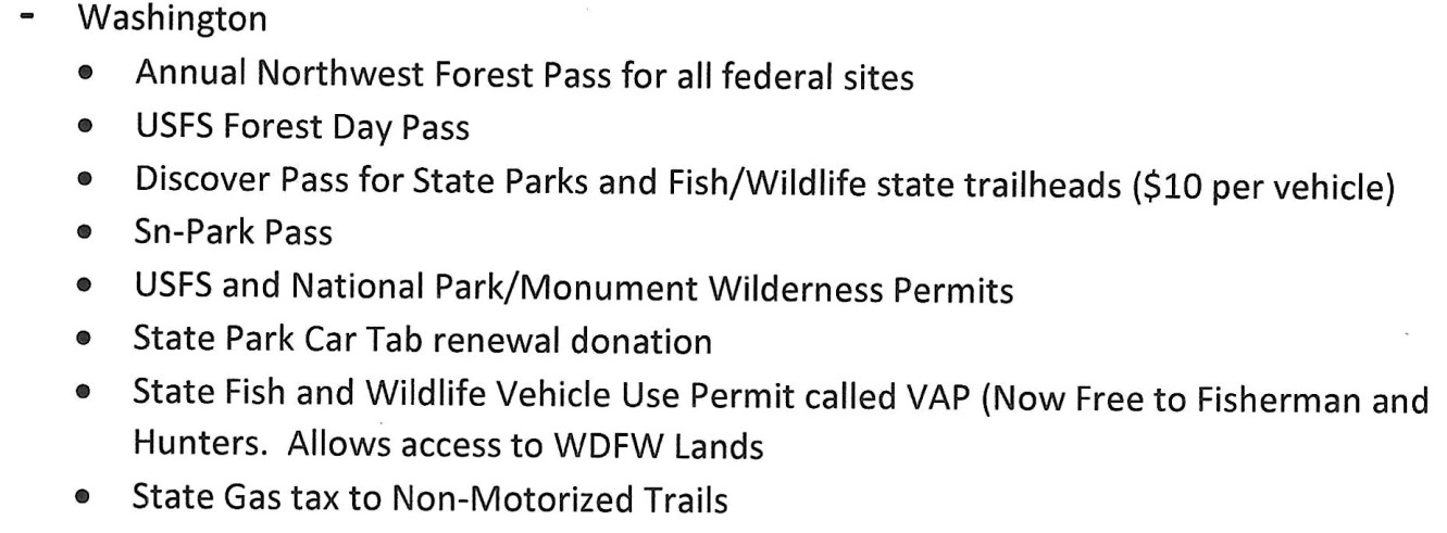
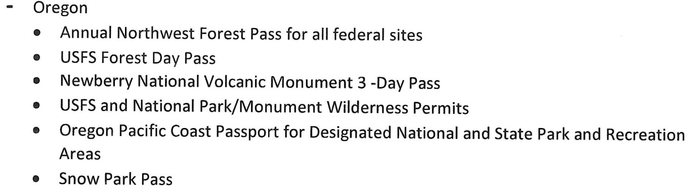
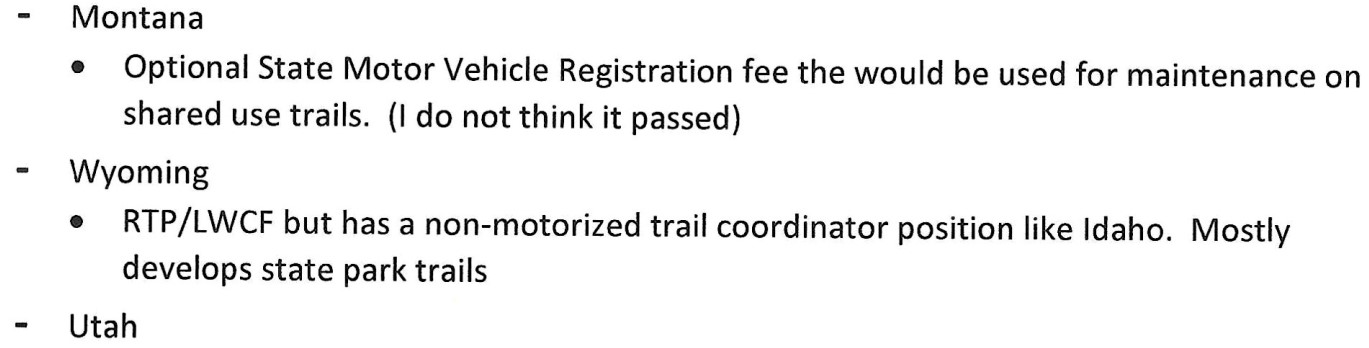
Non-Motorized funding by State
Idaho Horse Council Administrator is inviting you to a scheduled Zoom meeting.
Topic: IHC Non-Motorized Trails Initiative Meeting
Time: Jun 20, 2023 10:00 AM Mountain Time (US and Canada)
Join Zoom Meeting
https://us02web.zoom.us/j/87256562289?pwd=eTUvZE1aa0k1aTFNa0pFSjRRQUVuQT09
Meeting ID: 872 5656 2289
Passcode: 895117
—
One tap mobile
+16694449171,,87256562289#,,,,*895117# US
+16699009128,,87256562289#,,,,*895117# US (San Jose)
Idaho Non-Motorized Trails Poll
Non-Motorized Funding by State
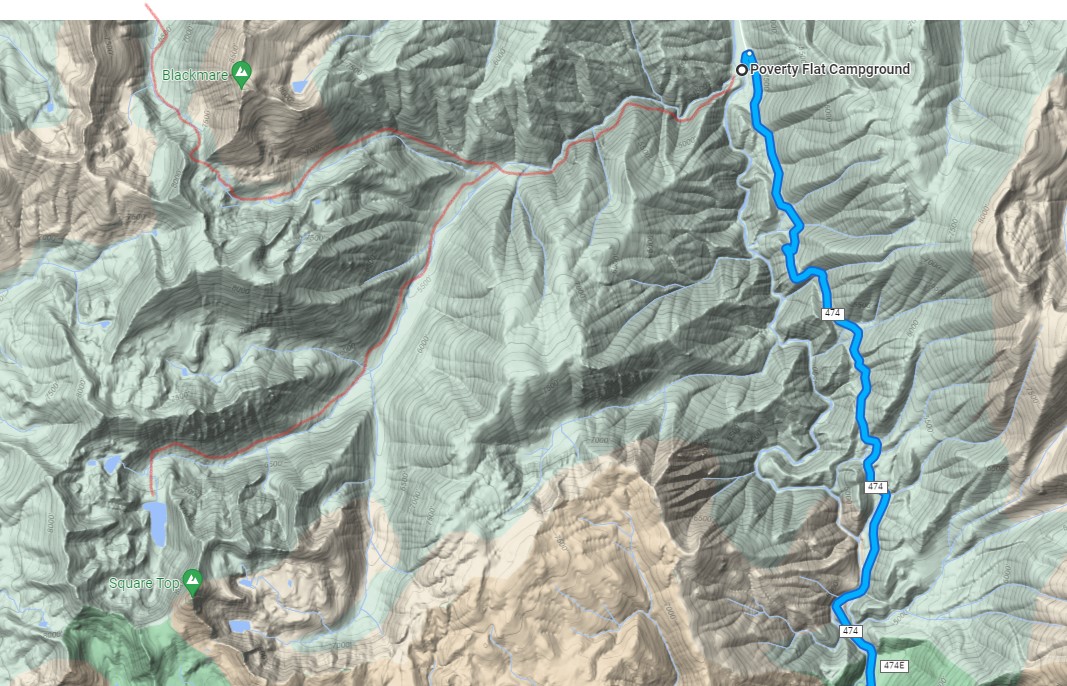
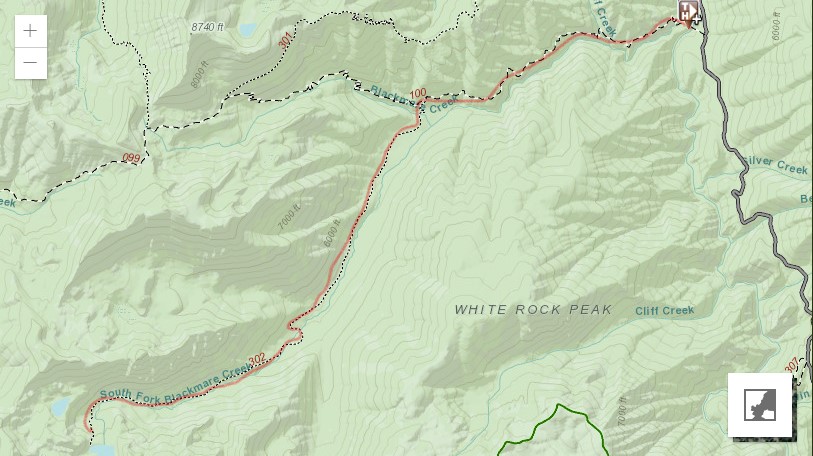
A short update on the Idaho Trails Association South Blackmare Trail trip June 11-17
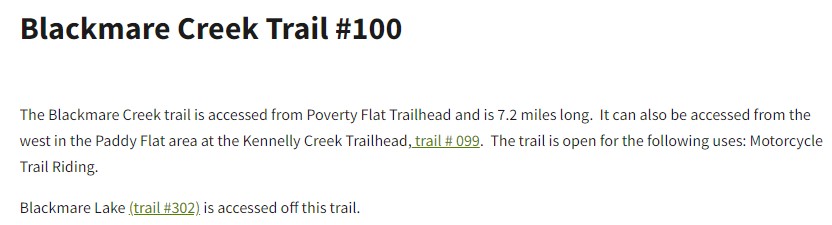
We had a good trip last week. Due to imclimate weather we had a few mid afternoon stops earlier in the week, but ended the week with some nicer weather. We worked mainly on Trail 302, but also did some logging and brushing along Trail 100 as we went in and out to better accommodate stock. The 8 participants removed approximately 379 trees from the trails – either cut out or moved, as well as performed brushing along the majority of the approximately 1.6+ miles of trail 302 we were able to cover. We also did tread work in a number of areas.
More details and stats to come, but I wanted to give you an overview. The attached KMZ has the trail from near where we camped (perhaps the southside of Blackmare creek) to where we turned around. Work was also done from camp up to the junction with Trail 100.
Please let us know if you have any questions we can address in our more detailed report.
Kirsten Severud
ITA Crew Leader
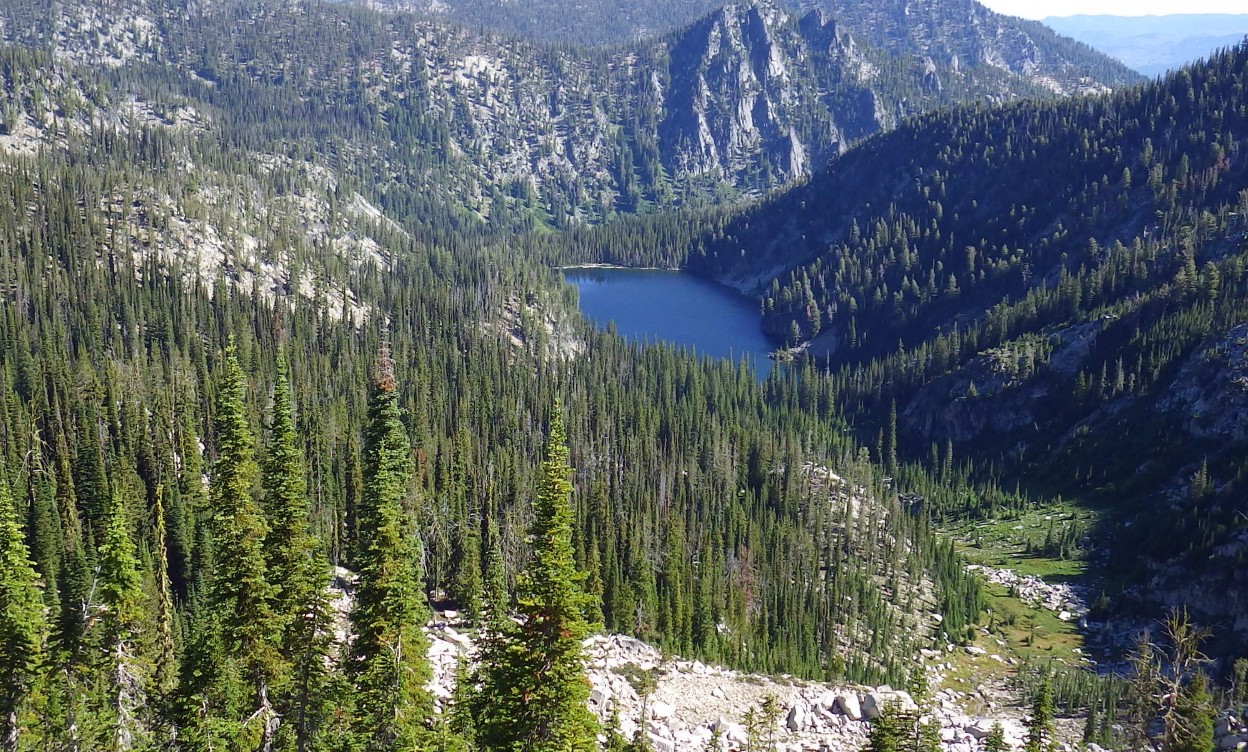
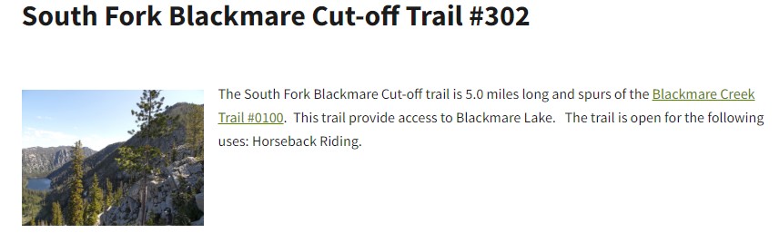
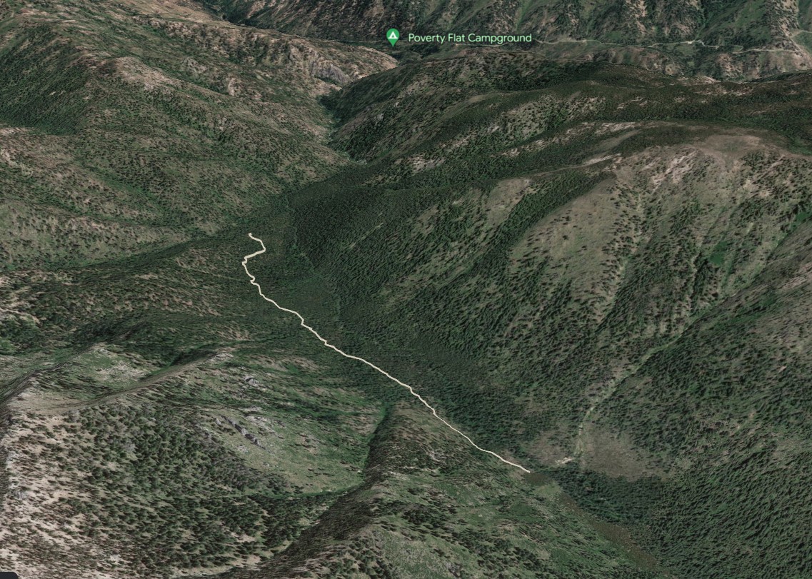
I packed them in and snapped just a couple photos bc it was raining much of the ride. I will send more pics of the work the crew got done (about 2 miles past where Blackmare and SF Blackmare split) over the week when I get them. This was truly a “lost trails found” effort, as the trail was almost entirely overgrown and even required scouting to find it, and some tread reestablishment. A good effort by the crew and one more hitch would probably be enough to get to the lake but we won’t get to it until next year.
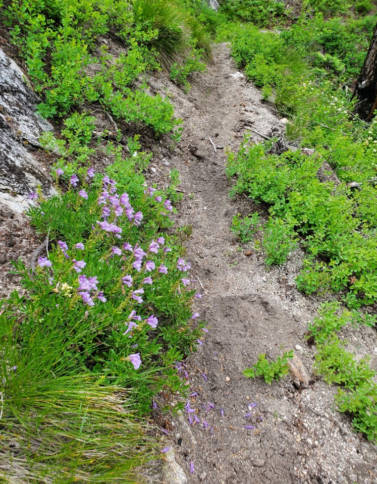
The first mile or so is the most exposed trail- like Jeff said, steep granite slopes. The rest is mellower.
Melanie Vining, Executive Director Idaho Trails Association
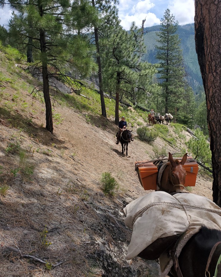
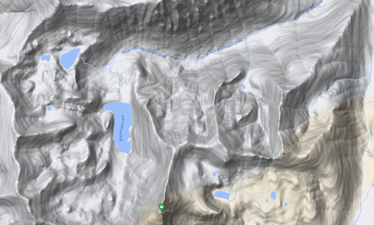
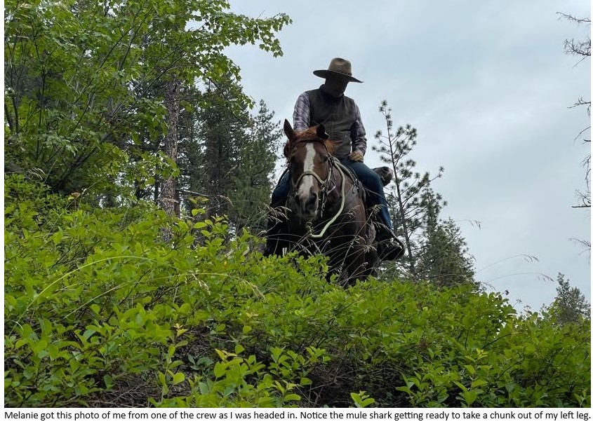
So yesterday was the ITA pack out from Blackmare lake in the south fork of the salmon. The trip went well, weather forecast was sunny and 70 degrees. The high I saw was was 59 and rain most of the trip. The trail was in great shape though the elevation gain and loss was about 2000 feet and most of the 4.5 miles in you are hanging on granite outcroppings that are sticking out of 70 degree side slopes of sand. The crew of six people made for big loads on 3 mules. Everything went well and got to spend the day in a beautiful canyon on horseback. Jeff Halligan BCHI

In this illuminating book, brain scientist and horsewoman Janet Jones describes human and equine brains working together. Using plain language, she explores the differences and similarities between equine and human ways of negotiating the world. Mental abilities—like seeing, learning, fearing, trusting, and focusing—are discussed from both human and horse perspectives. Throughout, true stories of horses and handlers attempting to understand each other—sometimes successfully, sometimes not—help to illustrate the principles.
Horsemanship of every kind depends on mutual interaction between equine and human brains. When we understand the function of both, we can learn to communicate with horses on their terms instead of ours. By meeting horses halfway, we achieve many goals.
We improve performance.
We save valuable training time.
We develop much deeper bonds with our horses.
We handle them with insight and kindness instead of force or command.
We comprehend their misbehavior in ways that allow solutions.
We reduce the human mistakes we often make while working with them.
Instead of working against the horse’s brain, expecting him to function in unnatural and counterproductive ways, this book provides the information needed to ride with the horse’s brain. Each principle is applied to real everyday issues in the arena or on the trail, often illustrated with true stories from the author’s horse training experience. Horse Brain, Human Brain offers revolutionary ideas that should be considered by anyone who works with horses.
![]() Background:
Background:
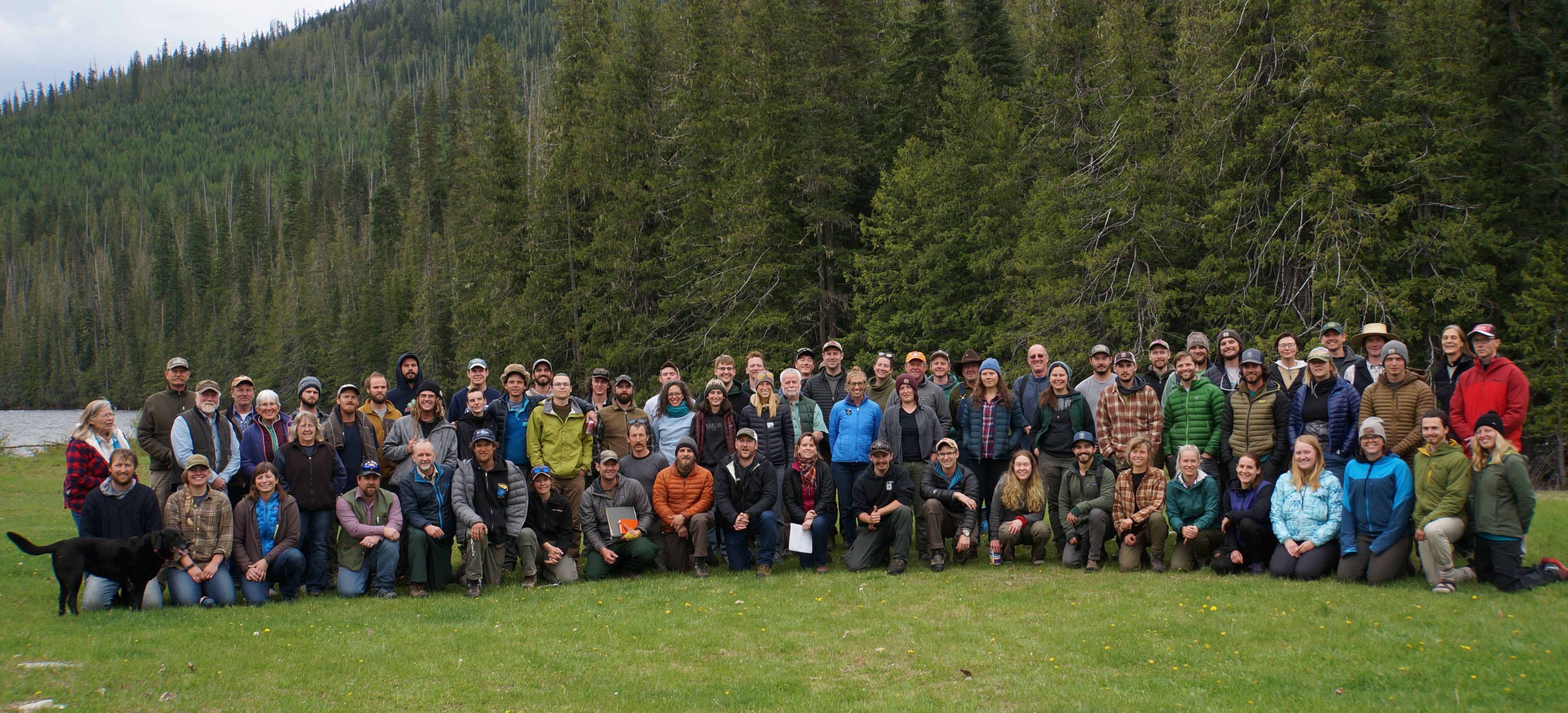
In 2018 Forest Service staff and partners developed a week long training program with the vision of “providing the highest quality Wilderness training program in the Northern Rockies that will educate, support, and cultivate a community of present and future wilderness and wildland stewards through the cooperation of the Forest Service, partners, and volunteers.”
The Northern Rockies Wilderness Skills Institute (NRWSI) is a training partnership between multiple partners that include the Selway-Bitterroot Frank Church Foundation, Society for Wilderness Stewardship, United States Forest Service, and the Ninemile Wildlands Training Center. The Institute currently features one week of training hosted each year. NRWSI has been put on hold for the last three years but now we are ready to bring practitioners back together again in person in 2023.
The 2023 Northern Rockies Wilderness Skills Institute will be held from May 22 – 26, 2023 in Powell, ID. It will start at 1pm PT on Monday and conclude at 3pm PT on Friday. All participants are expected to sign up for the entire week. The planning team is currently pulling together the training sessions and the application process will open up in March with a deadline to register no later than April 7th.
COST: There is no cost to attend.
FOOD: On your own – no food provided. Participants will handle their own meals. Cooking facilities may be provided – more information will be provided ahead of the event.
CLICK HERE FOR SESSION DESCRIPTIONS
APPLICATION WINDOW CLOSED (If interested contact them about a place in the 2024 workshop)
Please contact Jimmy Gaudry (jimmy.gaudry@usda.gov) or Carol Hennessey (carol.hennessey@usda.gov) for more information.
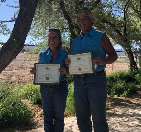
Congratulations to Lisa Griffith and Shelly Duff
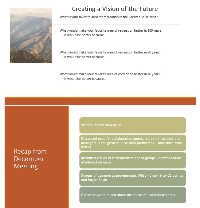
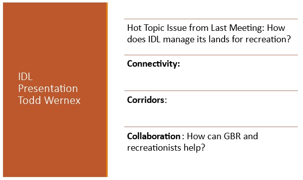
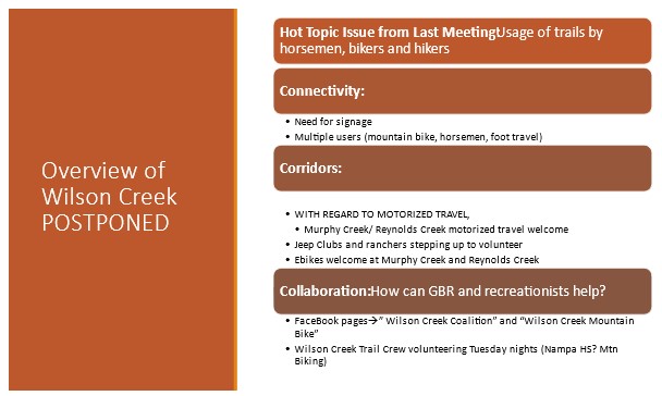
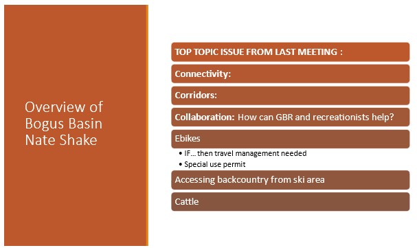
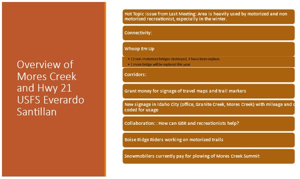
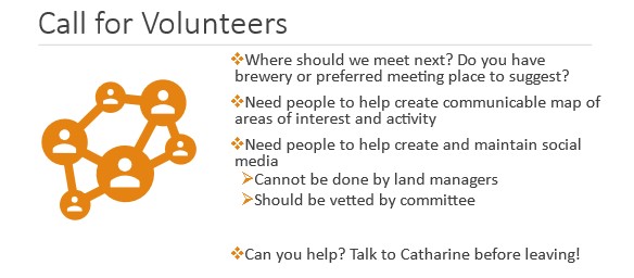
Thank you for your participation and a special thanks to our presenters!
If you weren’t able to join us please find the highlights attached. If you would like to participate in our “Vision of Recreation for the Future,” complete and return the first slide in the attachment and return to me.
If you are interested in volunteering space or refreshments for future meetings, web communications, or other ideas, please reach out to me via email.
We are coordinating our next meeting for August at the Bogus Basin Downtown Office. More details to come.
Best,
Catharine
Catharine Beverly-Bishop
Recreation Management Specialist
Forest Service
Boise National Forest
catharine.beverly-bishop@usda.gov
1857 HWY 16
Emmett, ID 83617
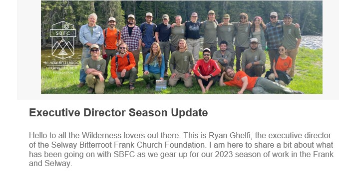
This past week I was fortunate enough to join our field leaders and Wilderness Ranger Fellows at the Northern Rockies Wilderness Skills Institute which took place at Powell Ranger Station near the north end of the Selway-Bitterroot Wilderness for five days. The skills institute brought together 150+ people from all over the region. There were many field-going folks, as well as program leaders from the Forest Service, people from the National Parks, and other nonprofit organizations like SBFC. Everyone was there to dive deep into the traditional skills and knowledge it takes to keep Wilderness accessible and wild for everyone.
I was extremely impressed with our SBFC staff and fellows. Our strong group of twenty showed a massive amount of enthusiasm and leadership throughout the week. None of them were afraid to speak up and to ask questions, even though many of our people, particularly our fellows, are very new to this world. I see so much strength and potential within this group. They have become great friends and it’s apparent that they will be ready for their first hitches in June to get into the Wilderness and do good work.
Thanks to all the people who helped to make the 2023 NRWSI possible, including our very own program manager Josh Page! Due to the major efforts of many, the future of our Wilderness lands are brighter than ever.
Looking ahead, we will be coming to you with regular blog posts from our field staff and fellows, as well as with other helpful communications to give you info and tools to get into these landscapes throughout the season. Let us know what you think and what you’d like to hear more of from us in the future!
Here’s to the Frank and Selway being wild and accessible forever!
I’ll see you out there.
Ryan Ghelfi
Tonight we are hosting a volunteer webinar on Zoom at 6:15 PM (Mountain Time). Come learn about our trail projects and get your questions answered! Sign up here!
SBFC will partner with Here Montana to take folks out on a stewardship project in the Bitterroot Mountains in 2023. Listen to their director Alex Kim talk about their mission.
Keep an eye out next year for information about the 2024 Northern Rockies Wilderness Skills Institute
Our friends at the Idaho Trails Association are looking for volunteers for a couple of awesome Wilderness projects in June on the Selway River Trail (women’s only) and out of Wilderness Gateway (family trip!)
SBFC has a few spots left on our single day volunteer project at Colgate Licks on June 3 and Horse Creek on June 21. Sign up before the spots are gone!
On Thursday, June 1, we are celebrating National Trails Day a few days early with a screening of Outdoor Idaho’s In the Shadow of the Bitterroots at Mother Earth Brew Co. in Boise. Learn more!
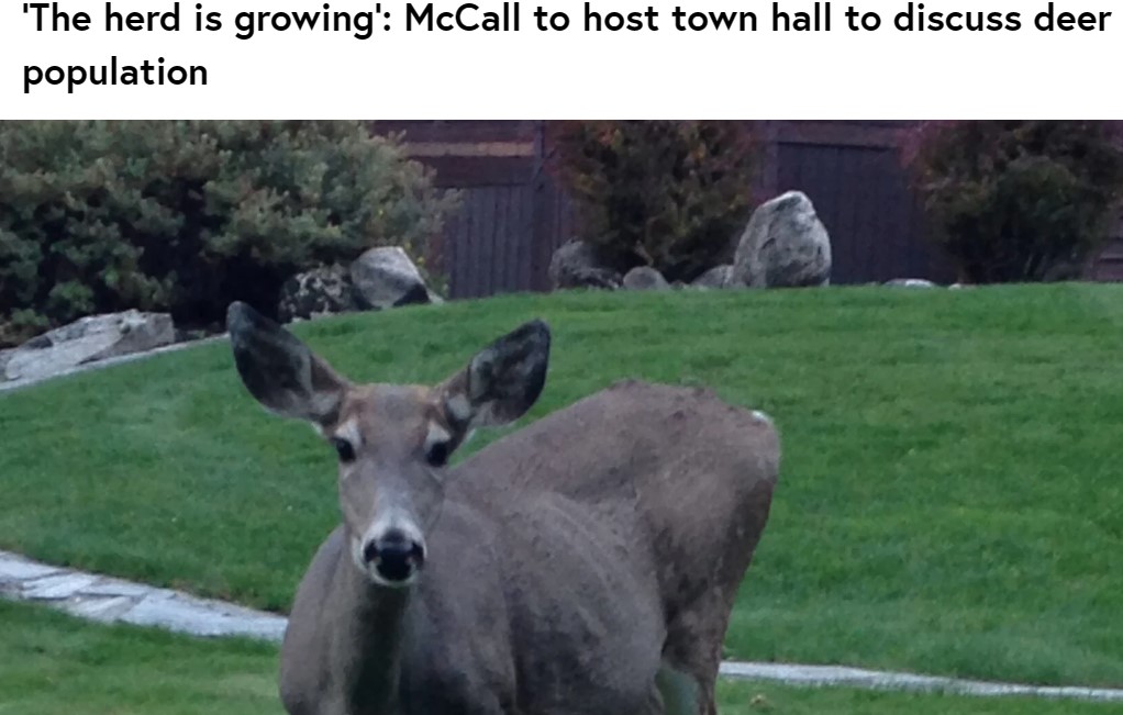

The deer herd that resides within McCall’s city limits is once again up for discussion.
Idaho Fish and Game gave a presentation to McCall City Council, warning that the deer problem could get worse.
Through surveys done over the winter, Fish and Game now estimate the in-town deer population to be at least 258. It was noted that there is a high fawn-to-doe ratio, meaning the herd is growing.
“We learned that we have a minimum of 258 deer living in town during winter. We observed that they’re quite habituated to people,” Regan Berkley of Fish and Game said. “…We saw a very high fawn to doe a ratio… But the essence of what that means is this is a growing deer herd. The fawn-doe ratio that we observed here in town is nearly twice what we usually see at that same time in winter range on our natural herds.”
Fish and Game has recently taken 40-plus calls from people reporting dead/injured deer. Berkley said this number is likely higher as the McCall Police Department is also receiving reports.
There was a trapping effort in late January in Cascade led by Fish and Game. It was stopped after 75% of the 20 captured deer had exotic lice. Berkley said there is “no reasonable medication or treatment” for this.
“Those had exotic lice and had to be euthanized. We did not go into that as a euthanasia effort. We went into it with the hopes that we would be able to translocate most of the deer that we laid hands on. That turned out not to be the case,” Berkley said. “We stopped trapping after two days to regroup.”
There have been two cases of exotic lice found in McCall deer – this prevents relocation to winter range. In addition to spreading lice, there is also concern about the growing mountain lion population from the influx of deer.
Fish and Game have received over 50 reports of mountain lions since mid-January, most of which have been spotted around Rio Vista Boulevard and Spring Mountain Ranch.
“It is not atypical for us to have some reports of mountain lions in town any given winter we get a couple here or there. This winter has been remarkable,” Berkley said.
More issues that come from feeding include deer getting trapped in things like hammocks and Christmas lights, and aggressive deer.
“Although not exclusively, it is mama deer that likely have a fawn stashed nearby that no one can see because that’s how they deal with their fawn….then when someone comes walking along unwittingly with their dog, we get reports of dogs being threatened and or actually stomped by deer nearly every year,” Berkley said. “…We do occasionally have deer actually being threatening towards people – not letting people get in their front door and that sort of thing.”

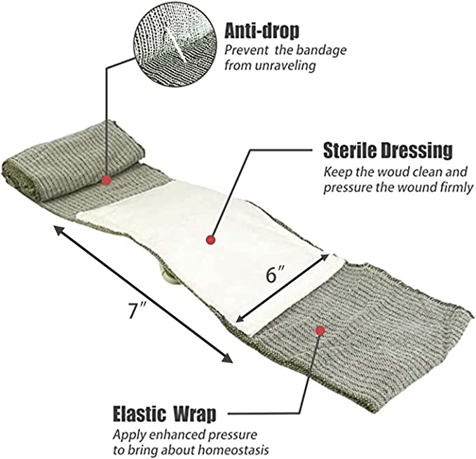
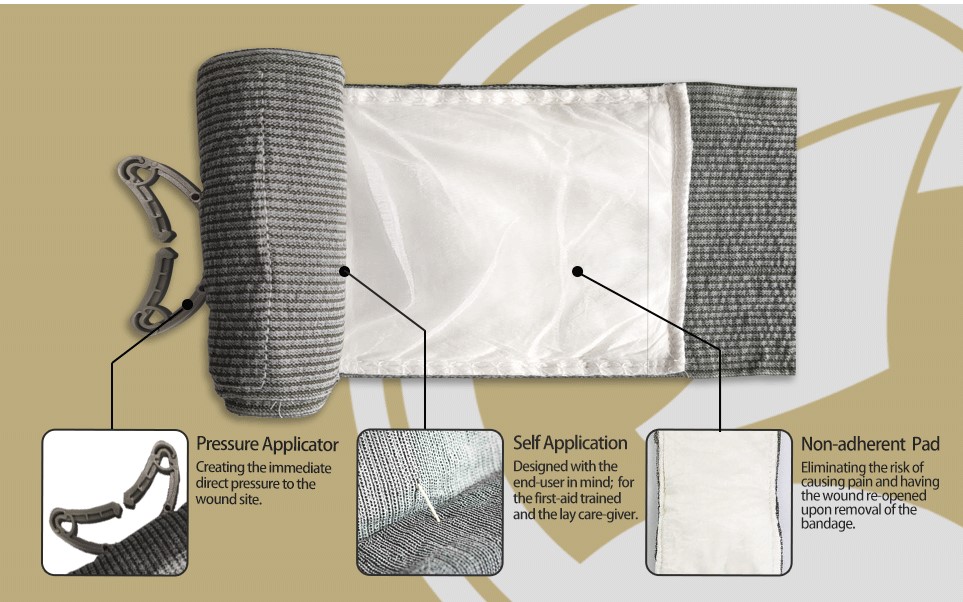
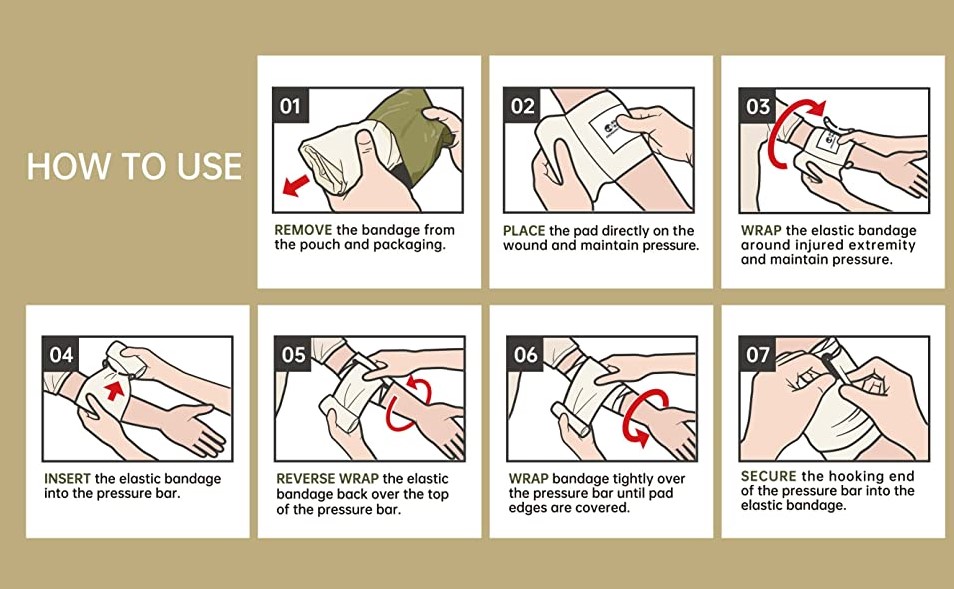
About this item
Non-pneumatic trauma bandage
Can apply 30-40+ lbs of pressure to the wound
Multi-functional bandage for various wounds
Compact, lightweight, waterproof, and vacuum sealed packaging
Sterile, best-in-class 8-year shelf life
Integrated pressure bar exerts immediate and direct pressure to the wound
Built-in closure bar: no pins, no clips, no tape, no hook-and-loop, no knots
Non-adherent 6″ pad eliminates pain during removal and prevents wound re-opening
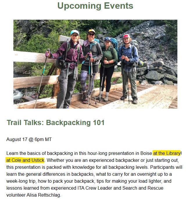
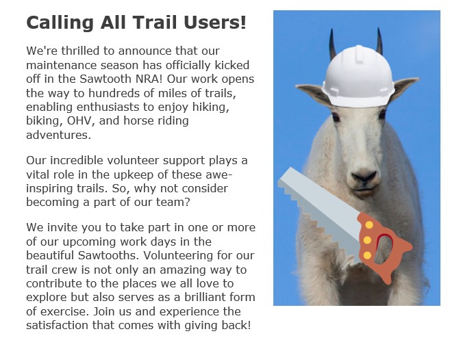
Want to brush up on your backcountry skills? We have some great (and free!) learning opportunities coming up. See our Upcoming Webinars and Events section below for more info about these in-person and online events: